Castle, Fortress, Palace, Prison: A Self-Guided Walk Around Akershus Fortress
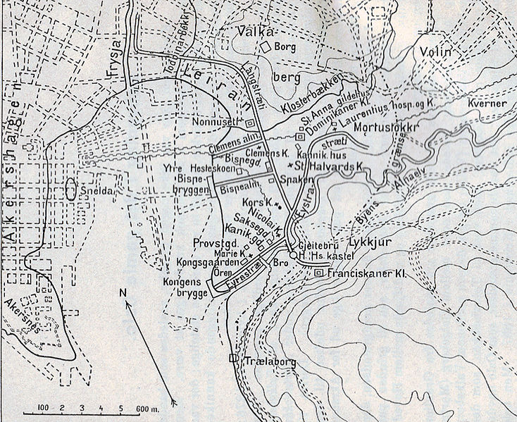
Dominating the Oslofjord skyline, Akershus Fortress is a mixture of medieval castle, military fortress, Renaissance palace, and prison. The fortress, as you can see, has had many different purposes over the years. Today it is still an active military base but is commonly used as a park and museum site.
The castle was completed some time around 1300 by King Haakon V of Norway, who moved the capital from Bergen to Oslo and built himself a castle. He used the castle as a residential palace and it was significant in establishing Oslo as the capital.
After Norway became part of Denmark, the castle became more of a military fortification.
Following the Great Fire of 1624, King Christian IV made the decision to move the entire city. He ordered the city be moved closer to Akershus Fortress, and the fortress was remodelled to look like a Renaissance Castle.
Akershus has successfully survived all sieges, mostly done by the Swedes.
For a few hundred years, Akershus was also the site of the prison that became known as The Slavery as you could rent out prisoners for the day.
This walk will take you through the history of Akershus Fortress and show you all the different purposes the fortress has had.
In this article...
Oslo Travel Guide
You can find a detailed overview of Oslo, including practical, historic and travel information on our dedicated travel guide page.
Facilities including supermarkets, toilets, petrol, hotels, cafes, restaurants with addresses.
The online guide is a summarised version of the downloadable guide. Some points of interest are only included in the downloadable guide.
The walk: Akershus Fortress
Information Centre
This walk begins at the visitor centre, which is located just within the fortress walls. The building is from 1774 and was the old artillery building.
Inside you can buy books, get a map, and purchase tickets for the museums.
The Carp Pond
Located across from the Visitor Centre
This small pond that we have today is from a much larger pond that used to be here. The stream came from Christiania Square and ran through this pond and down to Munk’s pond. It was divided into two when the foundations of the northern curtain wall were laid out in 1592. The other part served as a moat outside the wall.
The fortress guide says that carp are kept there in the summer, but when I visited in November 2020 the pond looked completely filled in, and a stage was built in front.
Akershus National Penitentiary, or "The Slavery"
Multiple buildings in this courtyard are from the prison.
When Oslo (then called Christiania) got renewed status as the capital in 1814, the fortress function changed. The outer parts were released as building plots for the public. The ramparts became a place for recreation.
The prison has been here since the 17th century, when King Frederik III said that all convicted of “petty larceny” should work on a chain group in Akershus, and eventually the prison got the nickname ‘The Slavery’ as prisoners could be rented out for the day. They were set to all kinds of public works and some were even hired out to private parties.
In 1842 there were as many as 530 prisoners here, all male. Amongst the inmates were the famous individuals such as Gjest Baardsen and Ole Hoiland. The world ‘slavery’ was abolished in 1850.
The Institution was converted into a National Penitentiary in 1902 and from 1937 it was a detention facility. During World War II, it was a German military prison. Briefly after the war the building was a prison for traitors, and it finally closed in 1950.
Today the buildings are used as office buildings for the military and fortress staff.
In the second photo you can see the prison chapel (behind the yellow buildings). It was built in 1896 and had tuition rooms and a library inside for the prisoners.
Drawbridge & Moat, Cannons
This bridge and gate is from 1653, though there has been an opening here since 1620. The drawbridge was rebuilt in the mid-19th century and a winch system was added (one of the winches is preserved in the northern part), but in 1920 the moat was filled in when the road below was completed. You can walk out onto the bridge today and pretend the road is the old moat!
In this large courtyard you’ll see some cannons. These cannons were to keep the prisoners in line, and they were loaded with grapeshot.
The Guardhouse
The guardhouse is from 1724 and has the Norwegian coat-of-arms above the front door. The building was used as prison facilities. Today the building is used as a guardhouse and museum for His Majesty the King’s Guard.
The Guardhouse has been used by the state in a modern context since 1947, when King Haakon VII used Akershus as a banquet hall in celebration of his birthday.
The Barracks
This area was originally a herb garden – it is shown as such in the oldest image of Akershus Fortress from the 1580s. The area eventually got a bathhouse, rabbit cage, and enclosure for deer. The barracks were built in 1778 and weren’t barracks for the military long; in 1787 the first prisoners moved into the northern wing.
Prince Carl's Bastion
We are moving back in time – here is Prince Carl’s Bastion, which was completed in the 17th century. There was a drawbridge and moat here; today it can only be seen from the outside of the fortress walls.
The Virgin's Tower
The Virgin’s Tower is one of the few original elements left – it was constructed around 1300 and is one of the many strong towers that used to surround the fortress. The tower used to be deeper and higher, but has changed over the years.
Munk's Tower
Munk’s Tower is from 1559. It is believed that the water tower used to be here, and it provided drinking water to those at the castle.
The name comes from Christian Munk, who had the tower built into its present form. Christian Munk was a Danish sheriff and governor who settled in Norway and saw major renovations of Norway’s fortifications. Throughout the 1560s he ruled over the regions Hamar and Akerhus while residing at Akershus.
For a while, in the 19th century, the royal regalia was kept in the tower’s top floor.
Castle Contrasts & the Southern Wing
The Southern Wing (to the right of the image) is one of the oldest parts of the castle. It dates from 1300 and was the original main entrance of the castle, nicknamed ‘the dark passage’. In the passage are remains of four fortified gates.
The area was renovated in the 16th century when a chapel was built in the area, and an extra floor (see the large building to the left) was added to make room for the chancery of the Akershus governorship.
When Christian IV ruled over Denmark and Norway, the area was converted into opulent apartments for the royal couple. The top floor is now a large room called Christian IV’s hall, and it functions as the castle’s reception room.
The Chancery Wing
Looking at the walls, you can see all the different periods of construction of the fortress. The bottom, grey part is the original castle and has been broken out of the bedrock. The big medieval bricks come next; they are known as the monks tiles. At the top, you see the parts from the 17th century that were added during Christian IV’s building operations.
The bit that sticks out was the lavatory facilities.
The Romerike Wing
The Romerike Wing is the building sticking out to the left. The lower part of the building was the storeroom with two fortified gates for taking in supplies. It was rebuilt in 1633 as the royal kitchen, while the second floor was used as living quarters for the viceroy. Between 1841 and 1845 the poet Henrik Wergeland had an office on the ground floor. At the time he was working as the national archivist.
Knut's Tower
You’ll now go through two stone archways. It’s a bit of an up-hill climb.
The tower you’ll pass as you go along the path is Knut’s Tower, one of the original parts of the medieval fortress. The tower used to be called the Canons Tower as it was constructed as a crossfire tower. For a long time, however, it was used to keep prisoners.
In 1641 the tower underwent changes as it was built into a horse-powered mill.
The name is a reference to the knight Knut Alvssøn, who was said to have lain unburied in the tower for 12 years after being killed by Henrik Krummerdike in 1502.
Execution Ground
This ground is the site used for the execution of members of Norway’s resistance movement. On the 9th and 10th of February, and the 17th of March, 1945, Norwegians were executed here by the Nazis.
A memorial was unveiled by Haakon VII on 8 May 1949.
Norwegian Resistance Museum
The building was originally the Double Battery and is from the late 17th century. It has housed Norway’s Resistance Museum since 1967. The museum is a fantastic insight into what the war was like in Norway, and the collection was arranged by ex-military and members of the Norwegian resistance.
Skarpenord's Powder Magazine
This huge building was built to be bomb-proof in the late 17th century. it has three ornamental sandstones from the viceroy Hannibal Sehested’s never completed fortress gave. The sandstone comes from a nearby quarry.
Visitor Centre
You have arrived back at the visitor centre! I hope you enjoyed this walk around Akershus Fortress.
Oslo Travel Guide
You can find a detailed overview of Oslo, including practical, historic and travel information on our dedicated travel guide page.
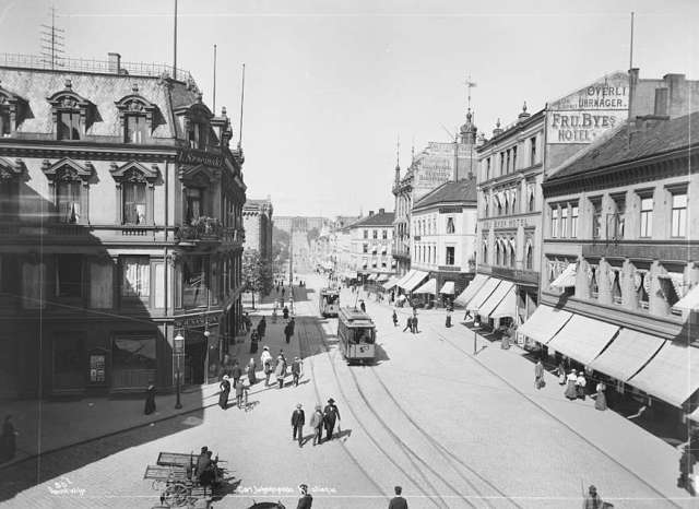
Christiania was the name of Oslo between 1624 and 1925. The name came from King Christian IV, who made the big decision after a fire in 1622 to move the whole city from its original location to be close to the Akershus Fortress. He laid the city out in a grid pattern (the area is called Kvadraturen, which refers to the grid layout), and designated certain blocks for certain purposes. And so, Christiania was built.
Many of the original buildings are now gone, but some still stand, albeit many are heavily renovated. Still, Christiania is a fascinating place to walk through and learn about how the old city of Oslo functioned.
On this self-guided walk, I’ll show you the buildings still standing, the story behind them, and try to give you an idea of what Christiania used to be.
A Brief History of Christiania
Christiania was established as a replacement of the old city of Oslo in 1624, after a huge fire had swept through the original city. Oslo stood a few kilometres to the east, but King Christian IV wanted the city to be closer to the Akershus Fortress. The ruins of the old city still stand at the suburb called ‘Gamle Oslo’.
The streets were built very wide, and the city was surrounded by ramparts to better protect itself. Additionally, all the houses were to be built in brick as a modern fire measure. However, most people were still too poor to build in brick, so wooden houses or half timber houses were constructed. The plots of land within Christiania were distributed to the citizens free of charge, but were allocated according to wealth and status.
The walled city of Christiania didn’t last long: after a fire in the 1680s the ramparts were no longer used and the city began to see unregulated expansion outside the walls. The city’s population rose steeply after the union with Denmark ended, and more modern buildings were built in Christiania to show off the city as a capital, including the palace, parliament and university.
By the early 20th century, the area of the original Christiania was a quiet business activity and no longer the centre of the city. In 1925, the city got its original name of Oslo back. Today, Christiania is distinctive on all maps of Oslo thanks to its grid pattern. It’s known as ‘Kvadraturen’ on maps, which refers to the grid pattern.
Facilities including supermarkets, toilets, petrol, hotels, cafes, restaurants with addresses.
The online guide is a summarised version of the downloadable guide. Some points of interest are only included in the downloadable guide.
Christiania Self-Guided Walk
Christiania Torv
This is the centre of the old town of Christiania. When Christiania was completed, the Holy Trinity Church stood on this site. It was the first public building to be completed in the old town, and by it would’ve been the market. The market was used on Wednesdays and Saturdays, and farmers would gather to sell their goods. The annual winter market in the first few days of February was also held here. Farmers came from all over Eastern Norway with butter, hides and venison. In the square was also the gauntlet and a ‘kag’ – a cane with a neck iron. Here the criminals were whipped and shamed.
The Holy Trinity Church used to stand here. It was a Renaissance building with four clocks and a richly decorated interior. Sadly, the church wasn’t even completed before it was struck by lightning in 1686. The bells of the church melted, and the nave was ignited. The fire destroyed about a third of Christiania, the northernmost part – which was the poorest area and mostly wooden houses – being the worst affected.
The church wasn’t destroyed during the fire, but it was decided to tear it down anyway because Akershus Fortress wanted an open field in the area and the church was blocking the firing range of the fortress. The Holy Trinity Church was demolished, and the site was left unused. What survived of the church was moved to the Oslo Cathedral when it was completed.
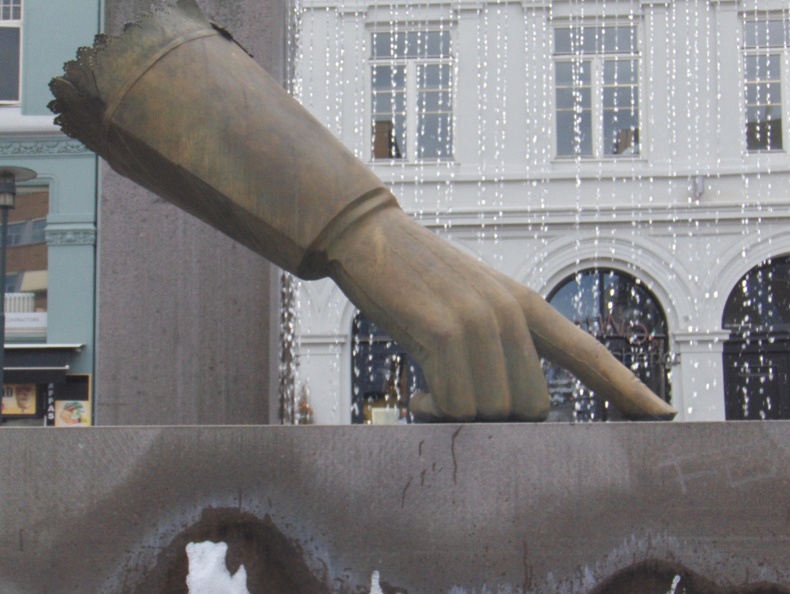
Christian IV's Glove
The statue in the middle of the square is called Christian IV’s glove and is by Wenche Gulbransen. It’s supposed to represent Christian’s decision to move the city here.
Anatomigården
This is one of the few remaining half-timbered houses in Christiania. The exact age of the property is unknown, but it is believed to be from the early 1700s. The name Anatomigården refers to the fact that the Faculty of Medicine had its anatomical hall here.
Rådmannsgården
This is one of the oldest buildings in Oslo and the best-preserved building in Christiania. It was likely built around 1626 in a Dutch/Danish Renaissance style. It used to be much larger but has undergone many changes over the years. The building was built for councillor (rådmann in Norwegian) Lauritz Hansen. Today there is a restaurant inside.
Gamle Rådhus
This is Christiania’s first town hall (Rådhus in Norwegian). The building dates to 1641, though it has undergone many changes over the years. For example, it used to have a tower, but it was torn down in the 1700s. The original Renaissance gables are also gone.
In Christiania, the town hall functioned as both a meeting place for councillors but also a gathering place for the towns bourgeoise. Kristiania was ruled by two mayors and 12 councillors appointed by the sheriff of Akershus Fortress. In the cellars were a detention room and a prison for convicted criminals.
The building was in bad condition throughout the 18th and 19th centuries, and over those years it was a Masonic Lodge. In 1983, it became a restaurant called “Det Gamle Raadhus”.
Revierstredet
The name comes from Revieret, a canal that was excavated in the area in the 17th century.
The dark brown building that you’ll follow along Revierstredet and then later onto Kongens gate is the oldest building you’ll see on this street. It was built in 1638 for a town bailiff and eventually became an orphanage. While it was an orphanage, 50 kids would be here. The women had to do yarn spinning, while the boys did carpentry. On the side, you can see the initials MHS and UMB, who were for the original owner’s Mads Haraldssøn and Annichen Mecklenburg. Parts of the property are among the first to be built in Christiania when the city was founded. The stone tablets in the wing towards Nedre Slottsgate indicate the building is from 1638, and according to the city antiquary in Oslo, this is Oslo’s oldest known building. There are traces of an even older building on the plot. The date 1640 on it is likely from an extension.
Bankplassen
The square comes from Norges Bank, which was built here in 1828. It is now used by the Museum of Architecture. You pass it on your right as you head into Bankplassen.
The square was renovated in 2016 for Norge Banks 200th anniversary. The square got new light poles using historic luminaires.
The Christiania Theatre was located on Bankplassen from 1837 to 1899. Cafe Engelbret quickly became a permanent place for many artists. The theatre was torn down to make way for Norges Bank, whose new building opened in 1900.
You can see Cafe Engelbret at the other end of the square.
Cafe Engebret
The restaurant is named after the founder Engebret Christoffersen, who started the restaurant in 1857. It moved here in 1863 and has undergone very few changes. The building is from 1760.
The Engebret Movement, a network of female journalists in Oslo, took their name from the place. They existed for 10 years and the goal was to promote female journalists in the business. The network worked for gender equality through the Norwegian Journalists Association. They wanted equal pay and better working conditions.
Café Engebret was popular for many artists because the old Christiania Theatre was located here from 1837 to 1899. Engebret became a permanent place for many artists. The theatre was torn down to make way for the second Norges bank building, which opened in 1900.
Kongens gate
This is one of the original streets of Christiania, laid out in 1624. If you turn right instead of left, you’ll see the road leads to the fortress. Most of the part we are walking through has been rebuilt over the years, with the buildings here from 1638.
Kongens gate 6 is from 1915. It is considered Norway’s first modern business building.
Tollbugata 19
Head into Tollbugata to look at building number 19.
This building is a small apartment building from 1687, though it has some parts on it that are older. The irons on the side of the building are beautifully decorated.
Prinsens gate 18
You’ve now made it to the north of Kvadraturen. On your right is a white building – this is Prinsens gate 18. It is the oldest house on Prinsens gate. It is from 1640 and was originally one floor but was later extended to two floors. Andreas Tofte, who was Oslo’s first mayor (1837-38), lived and ran a business here from 1824 to 1848.
In 1989, the property was severely damaged after a pyromaniac lit the building. The owner chose to restore the building, but it was upgraded to today’s standards. During the work, ceiling decorations from the 17th century were uncovered and restored
Prinsens gate
Prinsens gate is a 600m long street that runs through Kvadraturen. The street is mostly modern office buildings. Most were replaced after a large fire in 1858 destroyed 40 buildings. The buildings were rebuilt with businesses in mind, mostly because by this point fewer people were living in Kvadraturen. Historically, there were several pubs here and the street was very well known for its social activities. Halvorsen’s patisserie on Wessels plass has been running in the same place since 1881.
Kirkegata
The street, which means “Church Street”, runs from Bankplassen to Stortorvet, where Oslo Cathedral is today. It was originally called Prindsens gang and got its current name when Oslo Cathedral was completed. Originally this was a street for the rich, but after the fire of 1858 many properties were rebuilt for businesses. In the 19th century, this was the city’s main thoroughfare.
Rådhusgata 11 / Statholdergården
You’ve now made it to the north of Kvadraturen. On your right is a white building – this is Prinsens gate 18. It is the oldest house on Prinsens gate. It is from 1640 and was originally one floor but was later extended to two floors. Andreas Tofte, who was Oslo’s first mayor (1837-38), lived and ran a business here from 1824 to 1848.
In 1989, the property was severely damaged after a pyromaniac lit the building. The owner chose to restore the building, but it was upgraded to today’s standards. During the work, ceiling decorations from the 17th century were uncovered and restored.
Rådhusgata 10, 12, 14
This building was originally three small properties that were constructed at the end of the 1620s. They have all undergone changes through the years – they were last restored in 1980 and incorporated into Norges Bank.
Grev Wedels Plass
This is a lovely park that was laid out in 1869. The name comes from Herman Wedel-Jarlsberg (1779-1840), who was the president of the Storting (parliament), an ironworks owner, county governor, and finance minister.
After Akershus was closed as an active fortress in 1818, the area was turned into a government quarter. The Parliament and the Supreme Court were initially going to stand here, but it was banned by military authorities in 1836. The Park opened instead in the 1860s and quickly developed a bad reputation for hosting illegal activities. In the 1930s, it was paved over and turned into a car park. During World War II, the square was used for barracks and shelters. In 1988, the park was reconstructed and reopened.
The red building to your left is from 1840. The white building across the street and to the right is the Army Depot, a warehouse building designed in Empire Style from 1828. Further down is an orange building – this is Ridehuset. It was originally a stable but opened in 2007 as a concert venue. There’s an entrance to Akershus Fortress by Ridehuset.
Gamle Logen
The building on the opposite end is Gamle Logen. It was built in 1839 as a Masonic Lodge and banquet hall. Several events have been held in this building, such as a special dinner for Fridtjof Nansen and his crew after their first Fram trip. Until World War II, it was also a popular concert venue. Edvard Grieg (there’s a bust of him outside), Ole Bull, Johan Svensen and Halfdan Kierulf have performed here. After World War II, the building was used as the Court of Appeal, and this is where Vidkun Quisling was sentenced to death on the 10th of September 1945. It was also used as a canteen by Oslo’s dock workers. After extensive rehabilitation, it reopened in 1988 as a concert and cultural venue.
Military Hospital
Now you can see the Military Hospital. It is a beautiful wooden building from 1807 and was originally built as a hospital for soldiers. As Denmark-Norway was heading into the Napoleonic Wars, a new hospital was needed. After Norway became Swedish in 1814, it was a general hospital for the public, which it remained until 1883. It was then dismantled and taken to the Norwegian Folk Museum, where it sat in storage until 1983. Now it’s back at its original spot.
Garmanngården
At the corner of Rådhusgata and Dronningens gate is a beautiful red home. It is Garmanngarden, one of the city’s oldest standing buildings. Parts of the building are from 1622 (before Oslo burned in 1624), though most of the building is from 1625-1630. The anchors on the building have the date 1647, which is probably when the building got its current appearance. For its first 100 hours, the building was the residence of important men in Oslo, such as Land Commissioner Johan Garmann (where the property got its name from) and Governor Just Høeg.
The building was given to the city by King Chrisitan VI as the new town hall in 1734. It was also used as a courtroom, a meeting room for the magistrate, a theatre, concert and party room. There was also a police station, detention facilities and a prison.
Today the building is used by the Society for Oslo Byes Vel, which is a historical association that promotes the city’s history. All those blue signs on old buildings are managed by Oslo Byes Vel.
The War School
This building was established in 1804 to train officers for the Norwegian army. The students received a five-year education. Most of the cadets were listed, and the majority were the sons of officers. The school provided insight into military technology, general education, physical education, and military education. This is one of the world’s oldest military academies that has been in continuous education.
Posthallen
Across the street is ‘Posthallen’. It was built between 1914 and 1924 as Oslo’s main post office. Today the building is used as shops and apartments – the post office moved to a different building in 2004.
Pascal Patisserie
Diagonally across from the Military School is Pascal Patisserie, a very famous place for sweet treats. There has been a patisserie here since 1650. Sadly, the original building burned down and wasn’t rebuilt until 1870. The interior is left fully untouched from 1895.
The current owner is the ninth owner of the patisserie. It is Pascal Dupuy, a French pastry chef who came to Norway in the 1980s and opened his patisserie in this building in 1995. Pascal Dupuy has gained international recognition for his products, and he is considered one of the world’s best confectioners. He even has a show on Norwegian television that follows him educating his staff and creating unique pieces for special events.
There are multiple Pascal patisseries around Oslo, but this one is the one to visit. They serve French-inspired lunch dishes plus many good desserts. You can also admire the original interior, the glass roof, and a fresco painted by Åsmund Stray in 1895.
Treschowgården
This building was built for Gerhard Treschow, an immigrant from Denmark who became the customs officer in 1683. He ended up becoming one of the city’s largest factory owners with sawmills, brickworks, a paper mill, oil mill, and soap factory. He bought the property in 1710. For a while, it was the Cathedral School, and then it was a hotel. Today it is an office building for the Fred Olsen shipping company.
Oslo Stock Exchange
This building was built for Gerhard Treschow, an immigrant from Denmark who became the customs officer in 1683. He ended up becoming one of the city’s largest factory owners with sawmills, brickworks, a paper mill, oil mill, and soap factory. He bought the property in 1710. For a while, it was the Cathedral School, and then it was a hotel. Today it is an office building for the Fred Olsen shipping company.
Customs Office
This is the customs house. There have been five customs houses on this site – the first one was built by Gerhard Treschow in the 1680s, but it was replaced by the next customs officer, Frantz Jørgensen. He wanted his own customs house, so had it designed to his taste. The site used to be on the pier, but it was filled in 1957-1960.
Frantz’s customs house was so rotten by 1770 that it was torn down and replaced. However, in 1785 a huge fire destroyed the pier area, customs house included. In 1790 mason and architect Hans Christian Lind built a new customs house, now number 4. It was torn down and replaced in 1895. That building is the one we see today.
Customs Warehouse
This is a customs warehouse from 1915. Behind is the Tollpakkhuset, a customs warehouse from 1915. It now houses the Norwegian Customs Museum. The museum has all the uniforms spanning 350 years, plus all the stuff people tried to smuggle into Norway – this alone makes for a very entertaining visit.
Customs Office
You’ve now reached the library/Oslo Opera House area, with the Central Station on your left. I hope you enjoyed this walk around Christiania!
Enjoy More of Oslo
Visit the travel guide page to see road-trips, restaurants, and top activities that you can do.
The Bergen Railway is undeniably one of the best ways to get between Bergen and Oslo. The entire journey, which takes around 7 hours, crosses valleys and mountains, passes lakes and fjords, and shows you some of the best Norway has to offer.
Information online can be tricky, so I’ve gathered it all together in one straight-to-the-point article. After the practical information, you’ll find an overview of some of the stations you pass on the trip.
If you wish to support me, you can leave a tip by clicking the coffee cup on the bottom left of this screen. Otherwise, leave questions or kind words in the chat section.
Here’s everything you need to know before taking the Bergen Railway. Enjoy!
In this article...
Download this Guide
All of our guides can be downloaded via our online store.
We offer downloadable versions of our self-guided drives on our online store.
Facilities including supermarkets, toilets, petrol, hotels, cafes, restaurants with addresses.
Brief Historical Overview
The Bergen Railway was built between 1875 and 1909. The first section of the train to be built was the Voss Line, which runs between Bergen and Voss. It opened in 1883 after over a decade of planning and construction. The plan had always been to extend it to Oslo, but by the time the Voss Line was complete, Norway was in a recession. Parliament was not willing to give more money. In 1894, the matter was brought to parliament, and they voted 60 in favour (53 against) to build the Bergen Line. 12 different routes were surveyed over a period of six years. Construction finally began in 1901.
The construction process, as you might imagine, was very challenging. The high altitudes in a region without roads and a freezing cold climate made it difficult for the workers. The tunnels were all built manually through solid gneiss. The laying of track started in 1906 and took around one year to be completed.
The original train was a standard gauge. The first services started on the 1st of July 1907 between Voss and Myrdal. An official opening was attempted on 9 December 1907, but the train got stuck in heavy snow. The first train between Bergen and Oslo ran on the 25th of November 1909, and two days later the railway was officially opened at Voss by King Haakon VII.
The railway was used a lot during World War II for both civilian and military transportation.
After the war, plans were made to electrify the train. The line was electrified in four stages between 1961 and 1964.
Practical Information
Timings
How many trains run a day? Four trains to between Bergen and Oslo a day.
What time should I take it? If you are doing the Bergen to Oslo trip with Norway in a Nutshell all in one day, take the train that leaves Bergen around 8am. It’s also a good time to take the train because it gives you time to explore Oslo. The train gets into Oslo around 2:45pm.
What’s the best time of year to go? The train operates all year. It really depends on when you are travelling. It’s crowded in summer. I prefer spring: you get all the flowers and trees blooming closer to sea level, but there’s still snow on the mountains.
Tickets & Pricing
Buying in advance: Tickets can be bought up to 90 days in advance on our national rail website, vy.no.
Does it sell out? Yes! In summer and over winter holidays, it is very common for the train to sell out. Book as early as possible.
Are there any discounts?If you keep an eye out and book as early as possible, you may find the minipris tickets. These are heavily discounted, but they do sell out quickly!
Norway in a Nutshell: You can book the trip on the Norway in a Nutshell website, and this is worth doing if you are actually doing the Norway in a Nutshell tour (Bergen – Voss – Gudvangen – Flåm – Myrdal – Oslo). However, they tend to charge more than if you just booked it on your own. It’s a matter of ease and convenience.
How much do tickets cost? Ticket prices change a lot depending on the time of year and how close the train is to selling out
Komfort Class
Komfort Class is the ‘first class’ option on the train
Komfort Class comes with complimentary tea and cofee, plus charging ports
Is it worth it? Honestly, I think so. While the ‘advantages’ of Komfort class don’t seem worth the extra fare, I think it’s worth it because it’s so much more relaxing. In summer, the train gets overcrowded with noisy travellers and luggage. The Komfort section tends to be where the Norwegians go because it’s quieter. Being silent in this section is a little more enforced too.
Services on board
Cafe: There is a cafe on the train. They have drinks, sandwiches, chocolates, coffee, hot dogs, pizzas, and some warm food items (like a curry with rice). The café gets incredibly busy around the middle of the trip, and the carriage is tiny. It is very unpleasant if you try to get food then. Some items will sell out, too. If you wait to the end of the trip, you’ll be left with hot dogs as an option. I recommend buying cold food early and saving it until you want it. It’s cheaper to buy food ahead of time and bring it on board with you.
Alcohol? No alcohol is served on board
Wifi? Wifi is on the train in theory, but how well it works depends on what part of Norway you’re in. For example, it rarely works in the mountains.
Bringing Children: Close to the café is a playroom for children. It’s called the ‘Family Car’.
Language: signs on board are in Norwegian. Announcements are made in both English and Norwegian.
Apps
The Vy app allows you to download tickets and show them to the conductor. It’s much better than printing the ticket
The BaneNOR app allows you to track trains
Taking photos
Bergen to Voss: Mostly the left side
Voss to Myrdal: Mostly the right side
Myrdal to Finse: Mostly the right side
Finse to Geilo: Mostly the right side
Geilo to Oslo: Both sides work well.
For the photographers, the best places to take photos are in the doorways. At each stop, you can open the doors and take a quick snapshot. Just be wary of how long the train is stopping!
Buss for tog
If you see this, it means that part of the train journey has been replaced with a bus. It’s inconvenient but it happens if there’s work needed on the train. The bus doesn’t provide food or stops for toilets, so plan in advance.
Luggage
The train has very limited space for luggage. If you are breaking up the trip to do Norway in a Nutshell, I recommend having your luggage delivered to your hotel in Bergen or Oslo, depending on which direction you are going. Then take a small overnight bag on board the train with you. Check out the service ‘Porter Service’ (www.porterservice.no)
Tunnel Reality
There are over 180 tunnels on the Bergen Railway, so at times your view will be limited. This is very true in Western Norway; you must be quick with the camera!
The journey: Bergen to Oslo
Bergen
City
Bergen Station opened in 1913, four years after the Bergen Line was completed. Originally, the station was located further west (near where KODE 2 gallery is today).
At the time of construction, it was regarded as one of the grandest stations in Norway. The material used is granite and the style of construction is the National Romantic style.
As we leave Bergen, on the right side we’ll be able to see the city centre and the Lungegård Lake.
The Ulriken Tunnel is the first tunnel we go through. The tunnel is relatively new; before then, the first 32km (20 mi) of the journey out of Bergen was very slow because the tracks navigated their way around the suburbs. Three tunnels were constructed to eliminate that part of the trip. The tunnels were completed in 1963, and the first train went through in 1964.
The track is single track, which does create some traffic. A double track is planned. There is also a rumour that a road tunnel will be put through Mount Ulriken, which will eliminate the drive time from Arna down from 40 minutes to 10 minutes.
Tip: When we are in the Ulriken Tunnel, you lose internet signal.
Arna
Borough
After the Ulriken Tunnel was completed in 1964, Arna station was constructed. The old Arna station still exists, and it is used for the heritage trains that operate on the old Voss Railway in the summer months (click here for more info).
Arna is a borough of Bergen with a population of 13,000. With the rumours of a road tunnel, Arna is becoming a more attractive place for people to live.
Osterøy
Island
After Arna, we begin travelling along the Osterfjord, which is on the left side. If you want to get some photos of the fjord you have to be quick – there are many, many tunnels on this part of the journey!
The Osterfjord is around 27km (17 mi) long, 1 – 3km wide (0.62 – 1.86 mi) and the deepest point reaches a depth of 639m (2096ft) below sea level.
On the other side is the island Osterøy. It is Norway’s largest inland island (i.e. not directly adjacent to the ocean) at 328km2 (127 sq mi).
There are two road bridges that connect Osterøy to the mainland. We’ll pass one of them – the Osterøy Bridge – which is from 1997.
Trengereid
Village
Trengereid is a small village that is still part of Bergen. The village is known for its fabrics factory, established in 1895. At one point, the Trengereid Fabrikker (1895-1999) was one of the major Norwegian manufacturers o lace, ribbon, cord and elastic. You can learn more about the factory on the Industrial Museum website.
Trengereid is the starting point for many hikes on Bergen’s easternmost mountains, including the tallest mountain in Bergen municipality: Gullfjellet.
On your right side will the the residential neighbourhood, high on the hillside. On your left will be the fjord, the old factories and the docking facilities.
Only the Bergen – Voss railway stops here. The station was built in 1908.
Get the Guide!
We have a printer-friendly guide to the popular Norway in a Nutshell trip. This guide includes information about each point of interest, including historical overview and images.
Dale is located on the western end of the Bergsdalen valley. The population is 1,193. Historically, Dale has been an industrial place. The town was built around the Dale Power Plant and the Dale Factories. When the factories were built around 1879, there was only one small farm. By the end of the 19th century, the factory had around 500 employees.
On your right side, you’ll be able to see Dale Church (from 1956) as we approach the village. Also on the right side will be the Dale of Norway factory, a famous company that manufactures wool sweaters. There is also a textile mill here.
The Dale Factory is open, and there is an outlet store if you want to buy a sweater or some yarn at a discounted price (the sweaters are famously expensive!).
The E16 (European Highway 16) runs through Dale. Dale Station is mostly used by the Bergen – Voss Railway, though some express trains do stop here. The station is from 1888.
Voss
Town
The journey between Dale and Voss is very scenic, with a famous salmon river alongside side.
Eventually the tunnels end and the Voss Lake appears on our right-hand side. For most of the year, the mountains in the background will have snow on them.
With a population of 14,168, Voss is a large town and main hub for the region. It’s located between the Sognefjord and the Hardangerfjord, which has made it attractive for tourists.
Shortly on your right, just as the train approaches the station, is the Fleischer’s Hotel. The hotel was completed in 1889 in the Swiss Style. The name ‘Fleischer’ comes from a well-known family who have lived in Voss for many generations. The hotel is lovely, and if you want to break up the journey this is a highly recommended place to stay. Voss is a great place to spend a couple days – here’s the VisitNorway page for the town.
Voss Station was opened as the original terminal station of the Voss Line in 1883. It was on this platform that King Haakon officially opened the Bergen Railway on 27 November 1909.
Sometimes the train will spend 10-20 minutes here before continuing. If that’s the case, you can leave the train and take some photos of the hotel and the troll statues that are along the platform.
You will notice the huge Voss Gondola on the platform. This is a brand new attraction (completed in 2020), and if you go to the top you’ll have amazing views. Click here to view their website.
Shortly after leaving the station, you’ll pass the old Voss Church (Vangskyrkja). The church is from the mid-13th century and is built in a Gothic style. The whole region was Christianised by King Olav (Saint Olav), and the first church (a wooden church) was built shortly after that. This stone church replaced the old wooden church. Amazingly, the church was not destroyed during World War II.
After the church, you’ll see the main downtown area of Voss. It’s very concrete and may seem unattractive. The reason for the concrete facades is the destruction from World War II. After the German invasion of Norway on 9 April 1940, Voss was the main place for the Norwegian Army in the West. The Nazis were met with strong resistance from the Norwegians here. To break down the resistance, the Luftwaffe bombed Voss on 23 and 24 April. The bombing completely destroyed the historic town centre.
Once we are out of Voss, the scenery begins to become more dramatic. The stretch between Voss and Myrdal takes us through a narrow, rocky valley. On your right will be spectacular views out to the mountains.
We pass many stations along the way, but the train very rarely stops there. Sometimes they do if someone on board has requested the train stop. One such station that may have a stop is Mjølfjell.
Mjølfjell is a village with mostly cabins – in total, there are about 500 cabins here. Most are used as vacation homes by people from Bergen. The area is very popular for hiking and skiing. In the village you’ll find a grocery store, a chapel, and a military training facility.
The area grew after the establishment of the Bergen Line. There used to be a number of mountain hotels here. One still stands: the Mjølfjell Mountain Lodge. It is a high-end hotel with an outdoor pool, sauna, hiking trails, ski resort, and much more. Mjølfjell does have road access: the road actually ends here. All the following platforms have no road access.
The name Mjølfjell refers to the mountain: the colour of the white anorthosite looks like flour, which in Norwegian is mjøl. So the name is ‘Flour Mountain’.
Upsete
Hiking Area
Much like Mjølfjell, Upsete is another place the train may stop at if it’s requested. Upsete does not have a road access. There is a lovely place to stay: Upsete Fjellstove. The hotel is open in the summer and offers hikes and bikes that you can ride on the Rallarvegen.
The train station opened in 1908 as Opset Station; the name Upsete came in 1921.
Myrdal
Junction with the Flåm Railway
Myrdal is a tiny station but it is very well known due to its location. Myrdal is one end of the famous Flåm Railway – the train journey down to the Flåm village is often regarded as one of the most beautiful train journeys in the world.
The connection to Flåm was not intended for tourists; rather, it was established to link the Sognefjord to the main Bergen – Oslo train and transport goods and people up from the fjord region. Originally, the connection was supposed to go from Voss down to Gudvangen. In 1908, the decision was made to have the train go from Myrdal to Flåm. They estimated that 22,000 passengers would use the train a year. In 2008, the passenger count was almost 600,000!
The majority of people who come to Myrdal don’t spend long here; instead they use it as a place to change trains. There is no road connection to Myrdal.
People did used to live in Myrdal; there are remains of old iron ore mining and animal husbandry. Nobody lives here anymore, though some do own cabins here.
The station is located between two tunnels on the Bergen Line: The Gravahals Tunnel to the west and the Vatnahalsen Tunnel to the east.
Myrdal has three platforms. Platform 1 is the principal platform on the mainline, and platform 2 is the alternative mainline platform located on the passing loop. The non-consecutively numbered platform 11 is the platform used by local trains to and from Flåm. The passing loop allows regional trains to cross with freight trains. At the station you’ll find toilets, a cafeteria, a souvenir shop, and a waiting room. The shops are only open in summer.
Tip: As we leave Myrdal, keep your eyes on the left. For a few seconds we’ll be able to see down the entire Flåm Valley. It’s just before going into a tunnel!
Hallingskeid is the westernmost station of the high mountain stations. It is regarded as one of the snowiest areas on the Bergen Railway. Due to the ewather, the station is located inside a ‘snow superstructure’. These structures are built over railways to protect them from snow in the most exposed areas. A total of 9.5km of the Bergen Railway has a snow superstructure; mostly in Hallingskeid.
There are no permanent residents at Hallingskeid; the station is operated remotely. In he area are many hiking trails, the Rallarvegen cycle path, and cabins.
The train will stop here upon request.
Get the Guide!
We have a printer-friendly guide to the popular Norway in a Nutshell trip. This guide includes information about each point of interest, including historical overview and images.
Just before we get to Finse will be the Finse Tunnel. It is the longest tunnel on the Bergen Railway: 10,589m! (6.5 mi). The tunnel was built to ensure the train could operate all winter. The highest point on the Bergen Railway, 1237m above sea level (4058ft), is passed while we are inside the tunnel.
Tip: As we leave the tunnel, keep an eye out on the right-hand side for a view of the glacier. If the weather is good, you’ll be able to see it here.
Finse
Highest Point
We’ve made it to Finse! Finse is the highest station on the Bergen Railway and is known across Norway for its plethora of outdoor activities.
Haugastøl
Hiking Area
Haugastøl is another high mountain station that can be stopped at upon request. The station has been unattended since 1997. The station is designed in a mix between the National Romantic Style and Art Nouveau and is from 1908. Haugastøl was originally known as Fjellberg, Norway’s highest altitude farm. People lived there until 1909, and today it is a holiday home.
Haugastøl marks the end point of the Rallarvegen in the west.
Geilo
Ski Town
Geilo is a small town with around 2,400 people living there. It’s located in the Hallingdal valley, a traditional region in Eastern Norway. Before the train came to Geilo, the area was remote with a few scattered farms.
Geilo was established as a town when the Bergen Line was constructed. The train facilitated Geilo’s development as the first skiing resort in the country, and it is still one of the largest. It is also known for having some of the most luxurious and expensive holiday cabins in Norway.
The ski season in Geilo runs from late October to late April, and there are numerous ski centres here for alpine and cross country skiing. Click here for more information about visiting Geilo.
Shortly after leaving Geilo, we pass the old Hol station from 1911. Hol Municipality is the largest municipality in Hallingdal, and 91% of the area is located at more than 900m above sea level.
Ål is a small town with around 5,000 people living here. There is a strong cultural tradition here, and folk music is important to the community. The Folkemusikkveka is held every May. The traditional industry here is mostly farming. Many livestock farms ae in operation with small herds of sheep, dairy cattle, and goats. Crop growing is difficult because of the steep valley walls.
Ål station is served by six express trains, and the station has historic locomotive stables that are protected by the Directorate of Cultural Heritage.
We are roughly at the midpoint of the Bergen Railway. The train is now 228km from Oslo and 243km from Bergen.
After Ål, the scenery begins to flatten with forests, rivers, and modest mountain areas. We pass Torpo Station, which used to be the central station in Hallingdal. The station is built in the Art Nouveau style and is identical to the station we saw at Geilo. One of the big attractions here is the Torpo Stave Church.
Gol is part of the Hallingdal Valley. There was a very ancient settlement here; in the year 1000, there were around 26 farms in Gol.
Gol is located at the crossroads between the E7, Highway 52, and County Road 51, which takes you to Fagernes and the E16. From Gol, you have excellent connections to Valdres, Hemsedal, Laerdal and Sogn.
Gol does have an industrial feel to it, but there are some fun things to do here as well. The Gordarike Family Park is a theme park designed around the Viking Era. A modern replica of the Gol Stave Church has been built as a tourist attraction in the park. Gol used to have a real stave church, but in the 19th century they sold it to the Oslo Folk Museum, where it currently stands. There’s also an open-air museum located in Gol. It is built around an old farm and consists of barns, lofts and wooden stables plus a mill, school and cabin.
The station is from 1907 and is a busy station. Historically, this was a junction and important trading centre with heavy traffic.
The station is served by up to six dailway express trains. This station opened in 1907.
Just after the train leaves Gol, there are many farms located up on the valley side.
Get the Guide!
We have a printer-friendly guide to the popular Norway in a Nutshell trip. This guide includes information about each point of interest, including historical overview and images.
Nesbyen is a small town with a population of around 3,500. It has a historic town centre, called Gamle Nes. Most buildings here are from before 1900. The area was mentioned in documents from the 1600s, when the valley of Hallingdal was ruled from Nesbyen. Here’s a nice self-guided walk around Nesbyen.
One of the big attractions here is the Hallingdal Museum, which is one of the oldest open-air museums in Norway (from 1899). It has a large collection of wold buildings; the oldest one is the staveloftet from 1340. Another popular place to visit is the old meteor crater just noth of the town. About 650 million years ago, a 200-300m meteorite struck the area.
There are many outdoor activities to do here. The most popular hike is up Hallingnatten, which is 1314m above sea level. From the top you can see most of Southern Norway, including Jotunheimen in the north and Gaustatoppen in the southwest.
Nesbyen is known around Norway for having the highest recorded temperature in the country. The record was 35.6C, recorded on 20 June 1970.
The E7 is located along Nesbyen, which is built over an ancient trade route from Valdres through to Odda in Western Norway.
The station is served by up to six daily express trains. This station opened in 1907. Trains often stop here. This used to be a central station equipped with turntable for turning locomotives and several industrial tracks.
Just after Nesbyen is the railway’s longest straight stretch. There are dense forest on both sides of the train. The railway follows the eastern side of the Hallingdal River, while the national highway is on the opposite side.
Tip: Keep an eye out for the Austvoll Water Tower on the right. In the era of steam locomotives, these water towers were common along the railway. The train had to stop often to replenish so the pressure on the boiler didn’t fail.
Flå
Town
Flå is the last settlement we’ll pass in the Hallingdal valley. Like Nesbyen and Ål, it’s located on the ancient trade route that went through Valdres to Odda in Western Norway. Flå has a population of around 1,000.
Flå is surorunded by stunning nature. There are forests, agriculture, and mountains as high as 1500m. Flå’s coat-of-arms is the head of a black bear. Close to the town is the conservation area where Norway’s last permanent bear population lived. Today you can see bears in Flå if you visit the Bear Park, which is popular with kids. They don’t just have bears; they also have elk, deer, wolf and lynx.
The station is served by up two daily express trains. This station opened in 1907. We don’t see much of the village from the station because it’s about 1km away.
After leaving Flå, we follow the Hallingdal River. Eventually we’ll start passing the Krøder Lake, which was named “Norway’s finest Lake” by Fridtjof Nansen.
Hønefoss
Town
Hønefoss is a large town and central hub with a population of around 14,000. The town name comes from the waterfall that runs through the town; you will get a glimpse of it as the train leaves the station. The town experienced huge growth during the beginning of industrialisation; the waterfall was exploited for power and sawmills went up in the region. The railway to Drammen was also important for the industrial town.
Hønefoss is located on the E16, which is the main highway between Bergen and Oslo. It’s also connected to the Norwegian National Road 35 and the National Road 7. The town is located to several factories, including Norske Skog Follum, which works in the timber industry.
There are many things to see and do in Hønefoss. One of the highlights is the Ringerikes Museum, which is known for its collection of iron, rune stones, and for holding the private collection of Jørgen Engebretsen Moe. Jørgen was a Norwegian author best known for writing a collection of Norwegian folkales which he edited in collaboration with Peter Christen Asbjørnsen. The Norwegian Train Museum is also located here, where the old locomotives are. In cooperation with the Norwegian Railway Club, it is working on the restoration, maintenance and operation of all railway equipment.
By the station is one of the country’s largest stone vault bridges, built in granite.
The stretch of railway between Drammen and Hønefoss was completed in 1868 and was used primarily for cargo.
The idea of a railway between Drammen and Hønefoss was launched in 1846, before any other railways were constructed in Norway. However, nothing happened for a long time. In fact, even the idea of a canal was floated. In 1863, Parliament approved construction of a line between Hønefoss and Drammen. The railway was completed in 1868. The next plan was the Bergen Line, which opened in 1909.
The region we are in is called Ringerike. It is rich in history and ancient culture. The region has a rich food culture, and the Ringerikspotatoes are quite famous.
After we leave the station, we’ll be going alongside Tyrifjord’s western side. Tyrifjord is actually the country’s fifth largest lake, and the maximum depth is about 330m. There are 13 fish species in the lake, making it known for its rich fisheries.
Vikersund
Town
Vikersund is a small town with a population of around 3,200. Historically, the town has been important for the paper industry. Timber was floated down on the Tyrifjord to the Drammen River, where it could then be exported.
Today Vikersund is known amongst Norwegians for its Ski Jumping Centre. The Vikersund Ski Jump is the world’s largest, and there are seven different slopes within the complex.
Vikersund was part of the Krøder Railway, which was completed in 1872 and primarily used for industry and transporting passengers. In the summer they operate special steam trains that you can ride.
After Vikkersund the train passes several old industrial sites that grew up along the river when industrial travel took over towards the end of the 19th century.
Hokksund
Town
Hokksund is a small community that was built up around an old farm. Part of the growth of the town can be attributed to the nearby silver mines at Kongsberg. When silver was discovered in Kongsberg in 1623, the King decided that a road should be built between Kongsberg and Hokksund. This road is the first official road in Norway.
The railway came to Hokksund in 1866, and this gave way to the development of the local business community. Several businesses still stand along the railway track. The original station burned down in 1897, and the new one was finished a year later. The station is designed in a monumental masonry style, and it is the oldest and best preserved station on this part of the journey.
After Hokksund, you go across the plainlands of the Drammen Valley. The Drammen river is on our left.
Drammen
City
Drammen is a large city with around 60,000 people living here. The city is located west of the Oslofjord on the Drammen River. Drammen was built up as a trading and industrial city; keep an eye out on the left as we go through Drammen; you’ll see beautiful old factories and the town centre.
The station opened in 1866 when the railway between Hønefoss and Drammen was completed. From Drammen, you can change trains and take the Sørlandet Line towards Kristiansand and Stavanger.The station is also served by trains to Oslo, Kongsberg and Eidsvoll, regional trains on the Vestfold Line and express trains to Bergen and Kristiansand. Since 2009, it has been the terminus of the Oslo Airport Express train.
The station has recently been modernised and expanded.
Shortly after leaving Drammen, we pass the Drammensfjord on the right and the hill area towards Finnemarka on the right. This is one of the most fertile areas in the country.
Sandvika
Neighbourhood
The train may stop at Sandvika. Sandvika has had city status since 2003. The Crown Prince’s residence is at Skaugum. The site goes back to the Middle Ages. It was handed to Prince Olav in 1929, and today it is private property of the royal family, unlike the Royal Palace and OscarsHall, which is owned by the state.
Oslo Tunnel
Tunnel
The last part of our journey is not very scenic: we have to make our way to the other end of Oslo city centre, and to do that we must go through the Oslo Tunnel. The Oslo tunnel is about 3.6km long and opened in 1980, the same time as the Oslo Central Station. Before this, Oslo had two stations: Oslo East and Oslo West. As you can imagine, it was not very practical. Today Oslo West is the Nobel Peace Centre, while Oslo East has been expanded into Oslo Central Station.
Oslo
City
You have made it to Oslo! You can find my guide to Oslo by clicking the button below.
We have a printer-friendly guide to the popular Norway in a Nutshell trip. This guide includes information about each point of interest, including historical overview and images.
Oslo is one of the best places to visit in Norway if you’re a museum junkie, and what makes it even better is that the major ones are located practically next door to each other! There are six museums in Oslo that focus on Norwegian culture, history and industry are located on a peninsula called ‘Bygdøy’. These museums are must-see’s for anyone visiting the Norwegian capital, but at first glance can seem a bit confusing; I’ve always found it tough to explain to groups, so I decided to sit down and map out exactly what you should see as well as how to do it. This is what I’ve put together.
Bygdøy is a peninsula located just outside Oslo’s city centre. The name comes from an Old Norse term that means ‘built district on the island’ as the peninsula was originally an island (the land has been rising). Due to its proximity to the city, real estate here is expensive: a small apartment will cost you $1 million USD, while a house will cost several million. In 2013, a house went on the market for $20 million USD, breaking records.
The most known museums in Oslo are located on Bygdøy.
The Royal Summer Residence & Oscarshall
Bygdøy hasn’t just attracted the wealthy; it is also home to the Norwegian Royal Family’s summer residence (you will see it if you take the public bus to or from Bygdøy). It’s believed that the land has been used by Norwegian monarchs almost continuously since 1305. The estate, Bygdø Royal Farm, was originally built in 1733 for the Danish governor, but after the establishment of a Swedish-Norwegian union, King Charles III purchased the land from the government. King Oscar I built the palace Oscarshall (visible from the main highway to Bygdøy & the ferry) on the grounds. King Oscar II constructed residences and also established the Norwegian Folk Museum on the ground. After Norway became independent in 1905, King Haakon VII and Queen Maud lived at the estate while the Royal Palace was refurbished. Since then, it has served as a summer residence for the royal family and is actively used every summer.
Today, Bygdø Royal Farm is one of the best examples of an upper-class 18th-century country house in Norway. It has ceased its function as a royal farm; King Harald handed over the user rights of the farm to the Norwegian Folk Museum, who are actively preserving it.
What does Bygdøy look like?
The Museums at Bygdøy
There are six museums you can visit at Bygdøy. Three of them focus on Norway’s seafaring and exploring the history and the other three focus on Norway’s history and culture.
Here’s my quick overview of the museums, numbered according to the map above. I’ve also included some tips about each museum.
Norwegian Folk Museum (Norske Folkemuseum)
The open-air museum contains over 140 buildings, sorted according to their county in Norway. Most notable is the Stave Church, which was relocated from the village ‘Gol’ in the 19th century. The museum has an excellent exhibition on the indigenous Sami population, as well as Norwegian farming culture. During the summer months, actors walk around the museum providing additional information and activities on the old ways of life.
Note- this museum takes 2-3 hours to explore fully and involves walking and hills. Not recommended on a rainy day. Viking Ship Museum
Viking Ship Museum
One of the most popular museums in Norway, the Viking Ship museum lets you get up close to real Viking ships from around the year 800 AD – and they are 96% original! Three ships are inside the museum, and there’s also an exhibition with the goods that were found in the ships when they were discovered in the 19th century. This is an unmissable museum, but keep in mind its popularity draws large crowds.
Notes- the souvenir shop is excellent! Bags cannot be taken into the museum. The ticket gives you free admission to the Historical Museum within a 48 hour period. Recommended visiting time: 45 minutes – 1 hour.
Kon Tiki Museum
The Kon-Tiki Museum is all about the exploration and research of Thor Heyerdahl, who is famous around the world for his crossing of the Pacific Ocean on the balsa-wood raft Kon-Tiki in 1947. Inside the museum, you can see the original Kon-Tiki, the Ra II, as well as artefacts from Easter Island, Fatu-Hiva and the Galapagos. The Academy Award-winning Kon-Tiki documentary is screened every day at 12pm.
Note- Combo tickets can be purchased for the Maritime Museum & Fram Museum. This museum sells ferry tickets back to the city. Recommended visiting time: 30-45 minutes
Fram Museum
The Fram ship is famous for its expeditions to the North and South Poles. The museum has excellent exhibitions about these expeditions, and you can also walk onto the Fram and see how the crew lived and worked together. There’s also an introductory film about the expeditions. This is my favourite museum!
Note- Excellent cafe and souvenir shop, which has an extensive book collection and lots of Arctic-themed souvenirs. Recommended visiting time: 1.5 – 2 hours
Maritime Museum
The museum covers Norway’s maritime history (makes sense) and has exhibitions about the Hurtigruten, maritime art, and the shipping industry.
Note- has a great cafe! Recommended visiting time 30-45 minutes.
Holocaust Centre
This is the centre for Studies of the Holocaust and Religious Minorities – it’s more of a research centre than the museum. The building is the former residence of Nazi collaborator Vidkun Quisling. There is an exhibition about the Nazipolicy of mass murder with special focus on the fate of Norwegian Jews.
Note- Long walk from the other museums. There is a Jewish Museum in Oslo if you want to learn more about Jews in Norway. There is a Resistance Museum in the city if you want to learn more about World War II.
Practical Information
Opening hours for the museums in Oslo on Bygdøy
Jan-April
May
June-August
Sept
Oct-Dec
Viking Ship Museum
10-16
9-18
9-18
9-18
10-16
Kon-Tiki
10-16
10-17
9:30-18
10-17
10-16
Fram
10-17
10-18
9-18
10-18
10-17
Maritime
11-16
10-17
10-17
10-17
11-16
Folk
11-16
10-17
10-17
10-17
11-16
Holocaust
10-16
10-18
10-18
10-18
10-16
Prices for the Museums
Adults
Seniors
Kids
Viking Ship
120 NOK
90 NOK
Free
Kon-Tiki
120 NOK
90 NOK
50 NOK
Fram
120 NOK
90 NOK
50 NOK
Maritime
120 NOK
90 NOK
50 NOK
Folk
160 NOK
n/a
40 NOK
Holocaust Center
70 NOK
50 NOK
30 NOK
Combination Tickets & Oslo Pass
The Fram, Kon-Tiki & Maritime Museums have combination tickets available:
2 of the museums: Adults 220 NOK / Seniors 160 NOK
3 of the museums: Adults 320 NOK / Seniors 240 NOK
If you visit the Viking Ship Museum, you can use the ticket for free entrance to the Historical Museum (located in the city centre) if used within 48 hours.
The Oslo Pass covers all the museums as well as public transport. The 24-hour Oslo Pass costs 445 NOK for adults.
Getting to/from Bygdøy to see the museums in Oslo
Option 1: Take the ferry
white line on the map.
The Bygdøy ferry runs from Oslo’s City Hall and stops twice at Bygdøy: Dronningen & Bygdøynes. The journey has incredible views of the Oslofjord, Akershus Fortress & Oslo city. The walk from Dronningen to the Viking Ship Museum may be a little long for some, but the Bygdøynes stop is right behind the Kon-Tiki/Fram museums.
The ferry doesn’t run all year: it runs from 15 March – 13 October. Keep this in mind when planning your trip!
One Way Ticket Cost: Adults 50 NOK (Seniors + Kids 50% off)
Tickets can be bought on board (10 NOK more expensive), at the ticket office on the pier, or at the Kon-Tiki Museum. If you have the Oslo Pass it’s free – you just have to show the pass on board.
Note – last year some of my groups had issues with the ferry being over-crowded during the high season, resulting in delays.
Timetable
Note – this timetable is from 2019. Hopefully they will publish an updated 2020/2021 timetable.
The pier at City Hall is easy to find: there’s a big sign saying “Ferry to the Museums”. Otherwise, look for pier 3. The Dronningen stop is signed from the Folk Museum, but it can be a little tricky to find (try to use Google Maps or the map). The Bygdøynes stop is also not marked, but you can see the pier from the Kon-Tiki & Fram Museums. The ferry is a pastel-yellow colour.
Option 2: Take the bus
Navy line on the map
The public bus network Ruter operates from the city centre to Bygdøy. The bus you are going to want is Bus 30.
City Centre – Bygdøy
The bus departs from both the central train station (Jernebanetorget) and the National Theatre before heading towards Bygdøy. It will stop four times on Bygdøy: Folkmuseet (Folk Museum), Viking Ship Museum, Bygdøynes (Fram, Kon-Tiki, Maritime) and Frimurerhjemmet (closest for Holocaust Center) before terminating at Huk.
Bygdøy – City Centre
If taking the bus back to the city from either the Viking Ship Museum or the Folk Museum, simply wait for the bus heading to Nydalen and get off in the city at the stop best for you.
It’s a bit trickier if you are leaving from Bygdøynes (Fram, Kon-Tiki, Maritime). The only bus that stops there is going to Huk. Get on the bus and get off at Frimurerhjemmet. From there, cross the street and wait for the bus heading towards Nydalen. This saves time and is better than travelling all the way to Huk and then waiting for the bus to turn around.
The journey from Bygdøy to the National Theatre (and vice versa) takes around 15 minutes. The buses come every 10-15 minutes depending on the time of day.
Tickets
If you have the Oslo Pass, the bus is free.
If you need to buy a ticket, a single adult ticket is 36 NOK for one hour of travel. Seniors & kids are 18 NOK for one hour of travel.
Tickets can be bought at kiosks and ticket machines. There are plenty of these in the city, but none at Bygdøy – if you are travelling this way, I’d recommend picking up a 24-hour card in the city before coming out. You can buy tickets on board, but you must pay in cash. Otherwise, if you have a phone you can download the Ruter app and use it to buy tickets.
Option 3: Walk/Cycle
green line on the map
The Oslo bike share bysykkel is located throughout Bygdøy and the city centre, and with that, you can cycle to or from the peninsula. To use the bikes, you will need to have the app on your phone.
If you are up for it, walking takes around 1 hour 15 minutes from the Folk Museum to the City Hall. Honestly, I wouldn’t recommend it. Once you are past the summer residence you walk alongside the main freeway into Oslo, which is noisy and not very nice. You do, however, walk along the water.
Getting Around Bygdøy
Say you start at the Viking Ship Museum and want to walk to the Fram Museum – how doable is it?
Pretty doable!
The walk between those two museums takes around 20 minutes, and you walk through the neighbourhood, giving you the chance to check out these upper-class Bygdøy homes. It’s not well signed for pedestrians; however if you keep an eye on the road signs, they point towards the museums. It is a little hilly in some places. The public bus follows the same route as the walking path, so as long as you can see where the public bus (or the countless tour buses) is going, you are fine!
If you have a bus ticket, you can also easily take the public bus between the museums.
Eating at Bygdøy
If you are after a quick bite to eat, the best museum cafeteria’s are at the Fram Museum and the Maritime Museum – both have simple sandwiches and pastries. For more sit down cafes, there is a great one at the Folk Museum. However, my favourite place to go to is Cafe Hjemme hos Svigers. Located between the Viking Ship Museum & Fram Museum, this cosy cafe has excellent sandwiches, salads, and small meals. The owner is typically always around for a chat, and the food is incredible considering how quick they prepare it. The cafe also doubles as an antique shop! I’d really recommend it if you need a break from the museums and want to try somewhere more local.
FAQ’s + tips
How crowded does it get at Bygdøy? During the summer, it gets very crowded. It’s not uncommon to see a dozen tour buses outside the Viking Ship Museum as it opens. Most tour groups visit the Viking Ship Museum & Kon-Tiki Museum, and they typically do so in the morning. If you can wait to the late afternoon, I’d 100% recommend visiting then. The Folk Museum can get crowded during the summer break as it’s very popular with kids
Should I use the hop-on hop-off bus to get to Bygdøy? I honestly wouldn’t recommend it. I understand the comfort of knowing how the bus works, having it in English, and it being catered to tourists, but the public bus is cheaper and provides a more local experience.
Can I do Bygdøy in a day? Technically, yes you can. However, you will be rushing through the museums. In 2018 my husband and I got a 24-hour Oslo Pass and did Bygdøy in a day. We started at the Folk Museum and then went to the Viking Ship, Kon-Tiki and Fram Museums – taking the bus to Bygdøy and the ferry to the city. We didn’t really focus on information at the museums and barely saw the Folk Museum. We were also exhausted by the end of the day. But it is possible!
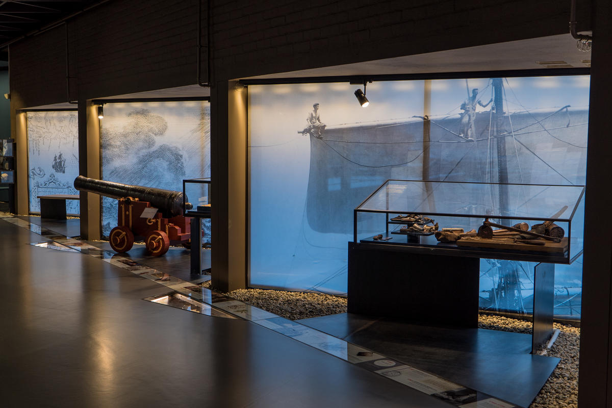
No trip to Norway is complete without seeing something to do with Vikings. Luckily, it is the Viking Ship Museum in Oslo can provide the Viking fix you need. Focusing on three Viking ships and their burial sites, the museum provides an incredible insight into the life of the Vikings, which is much more unique than many other museums which focus on their trading history. Instead, this museum focuses on what they found important to them, how they respected the dead, and how they viewed the after-life. Probably the most popular museum in the country, it’s hard to pass up a chance to see real Viking ships in person.
About the Museum
The museum focuses around three Viking ships that were uncovered in areas around the Oslofjord from the late 19th to early 20th centuries. The ships, titled Tønsberg, Oseberg and Gokstad (after where they were found), are the best-preserved Viking ships in the world.
Besides the ships, there’s also an excellent exhibition with the items that were found in the Viking ships. They are placed together to provide an incredible insight into how people were buried and what each item meant in the afterlife. There are also two graves – a man and a woman – that were uncovered with the ships.
Important: Renovations at the Viking Ship Museum
From autumn 2021, the Viking Ship Museum will close for five (!) years for a major renovation. Why? The current building and huge increase in traffic is causing the ships to decay at a fast rate. A new building will house the ships and protect them much better. They have a whole website with information about the new museum, but it’s all in Norwegian. Here are some highlights:
The new museum will be completed in 2025 (I think this will be delayed)
The new building will be climate regulated
The new museum will be three times as large as the old one
This will be an extension to the current building
The Three Ships
The Oseberg Ship
The Oseberg Ship is 96% original. It was excavated in 1904-1905 in what is considered the world’s largest burial site. Parts of the ship date back to 800 AD, but recent research indicates that the ship may be much older. This ship is the most popular for a reason; it so clearly evokes the power and strength of the Vikings and their seafaring capabilities. Spend some time admiring this beauty.
The Gokstad Ship
The second of the three ships you will see is the Gokstad Ship. This is the largest of the three ships and was uncovered in 1880. Inside this grave, they found a skeleton of a man in his 40s-50s with a powerful build. Some items were also found here, including small boats, a tent and riding equipment. While looking less like a Viking ship and more like a regular boat, it’s still impressive to see.
Be sure to walk past it to the end of the room, where you’ll see the two skeletons that were uncovered with the ships. The man mentioned above as well as a 25-30 year-old woman.
The Tune Ship
Opposite the Gokstad ship is the third ship – Tune. This is the least complete of all the ships but was the first excavated in 1867.
Behind the ship is one of the burial tends that was uncovered during the excavations. This is interesting to look at; especially how elaborate these graves were. Here you’ll see the smaller boats that were excavated along with the large ships.
What Else Can You See?
Watch the short film
A newer addition to the museum, there is a short film that plays on the ceiling above Tune three times an hour. The film, which has music but no words, provides an overview of the life of a Viking and Viking ship, from the time the ship is built to the time the Viking dies in battle and is buried. It’s an okay film and worth stopping for if you are there when it starts.
Explore the additional exhibition
The last corner of the museum is the exhibition, where various textiles, chests, jewellery pieces, and statues from the burial sites have been put on display. Information boards in Norwegian, English and German provide useful information into what the object is, as well as why it was buried with the individual. This part of the museum is where you’ll spend most of your time. See some images below – the best room in this exhibition is the textile room, but sadly images aren’t allowed there. Also, the glass cabinets make photo-taking a little tricky. But, of course, it’s much better in person 🙂
Facilities & Practical Information
Shop
I love a good souvenir shop, and this one certainly delivers. Think of it as ‘Viking overload’ if you can put a Viking on it, it’s for sale. There’s even a Donald Duck cartoon about the Oseberg ship. The book selection is the best in the country – most of the books are in English and cover everything (and I mean everything) about the Viking Age. I have bought a book on the Vikings in Norway, Norse Mythology, Snorre Sturluson’s Sagas, and one about a Queen called Emma (it felt fitting). There are t-shirts, posters, Viking helmets, keychains, magnets, figurines, statues, and so on. Prices are typical of Norwegian museums.
Museum Guidebook
If you are looking for a museum guide, the shop sells a book called The Viking Ships in Oslo. It uses some of the information from the signs around the museum, but also builds on the discovery and excavation of the ships, the design and build, the symbolic details, and how the ships are being preserved. It’s more novel than museum guide and not something you will read while in the museum, but it does provide an excellent insight into the ships, Honestly, after reading the book, I just wanted to go back and take another look at the ships – not something everyone will be able to do.
The book costs 69 NOK
Museum Brochure
The museum has a brochure that it shares with the Historical Museum, and it mostly provides an overview of the exhibitions in each museum. The information about the ships is the same as the information boards.
Languages
The museum has information boards in English, German & Norwegian. The brochure is available in more languages.
Notes
Crowds in Summer
The Viking Ship Museum is the most popular in Oslo, and when you go (especially during summer) there will be other people there. Almost every cruise ship offers excursions there, and almost every tour group goes there. It gets crazy packed.
If you want to avoid crowds, either visit out of season (Oct-April) or go in the evenings. Most tour groups & cruise ships do their tours between 8:30am and 12pm or maybe in the afternoon around 1pm-2pm. In summer the museum closes at 6pm.
Tickets & Security
As soon as you enter the building, the ticket office is immediately to your right (there may be long queues blocking the door). You scan your Oslo Pass, or pay for your ticket, at the ticket office.
Afterwards, there is a ticket inspector before you are able to enter the museum. This is not museum staff; rather, it is a security guard.
Bags are not allowed inside the museum. The security guard will be checking this, and you will have to leave your bag outside in a locker if he catches you. Be on the safe side and put your bag inside the locker before queuing to enter the museum.
When you buy your ticket it gives you free admission to the Historical Museum, provided you use it within 48 hours.
Practical Information
Opening Hours
1 October – 30 April: 10am – 4pm
1 May – 30 September: 9am – 6pm
Prices
Adult 100 NOK
Students/Seniors 80 NOK
Children under 18: Free
Oslo Pass: Free
Note – your ticket gives you free admission to the Historic Museum if you visit within 48 hours of the Viking Ship Museum
Getting Here
Take bus number 30 towards Bygdøy (stop: Vikingskipene)
The history of Oslo is truly fascinating. While today the city is very modern and there may seem like there are few traces of its beginnings, there are hints of history everywhere.
Here’s my summarised history of Oslo!
Humble Beginnings
Oslo is one of the oldest places in Norway; the area around the Oslofjord has been inhabited since the last ice age due to its rich agricultural land. The oldest settlements date back to the Stone Age and the Bronze Age. Historically the area was called Viken, which means ‘the bay’.
It’s believed that the Oslofjord was an important place for the Vikings; this is mostly because three Viking ships have been found in the area. These are now on display at the Viking Ship Museum. The first church, St. Clements Church (Klemenskirken), was built in Oslo around the year 1000. Sadly the church is no more; its ruins can be seen in the Middelalderparken just outside the city centre.
Medieval Oslo. Akershus is on the bottom left. The hilly area to the right is Ekeberg.
Oslo wasn’t officially founded until 1049. It was founded by King Harald Hardråde (Harald Hardruler), but it was his son, Olav Kyrre (Olav the Peaceful, who also founded Bergen), who set up a cathedral and a bishopric. Oslo wasn’t where it is today; rather it was founded closer to the region around Ekeberg and where the Barcode is today (the region called Gamle Oslo (Old Oslo) highlights this).
Mariakirken Oslo
Throughout the 12th century, cathedrals and a cathedral school were built around the city. This includes Mariakirken, which would’ve looked similar to the church in Bergen. Sadly, like St. Clements, only its ruins remain.
At the time it was Trondheim that was the capital of Norway. In 1219, the capital moved to Bergen. It wasn’t until 1299 that Oslo got its title as the Capital of Norway.
The Capital of Norway
In 1299, King Håkon V decided to move from Bergen to Oslo, and with that, the capital moved. He cemented the city’s status as the capital when he had the Akershus Fortress built in 1299.
Everything changed in 1350 when the Black Plague came to Oslo. Around half of the town’s population passed away, and the churches began to lose income. This is around the time that the Hanseatic merchants came in to take over trade, and the churches fell into ruins.
The entire country had lost a lot during the Plague, and because of that, it was forced into a Danish union.
Danish Union, Fires, and Kristiania
The Kalmar Union put the three Scandinavian countries together in 1380, and during this time trade in Oslo was dominated by Hanseatic merchants and the town had little going on.
In 1536, the Danish and Norwegian union became a formal coalition, and the capital proper was now Copenhagen – though Oslo remained a symbolic capital. Due to the Reformation, in which Norway converted from Catholic to Lutheran, many of the old churches (most of which were already deteriorated) were destroyed by the Danes to make way for Lutheran churches. There are many ruins of churches in Gamle Oslo (the old town) today.
In 1624, the city changed forever. A massive fire burned for three days, destroying most of the city as it was built in timber. After the fire, King Christian IV of Denmark decided that, rather than rebuilt the old city, he was going to move it and build a whole new city and name it after himself. So, he did. And so Kristiania was born. At the time, it was spelt Christiania, but from 1877 it was spelt Kristiania.
A statue of Christian IV pointing to where he wants Christiania
Inspired by contemporary city planning, Kristiania was laid out in a grid close to Akershus Castle. The architecture of the time was Renaissance, and there are glimpses of this style still visible in the old centre of Kristiania. Akershus Fortress was also modernised and converted into a renaissance castle by Christian IV. All citizens and shops were strongly encouraged to move their businesses and homes to the new city, and they did. Around this time, the lower classes started to settle a little out of the city, near Vaterland and Grønland near the Old Oslo area.
Oslo’s first town hall from 1641
The area of Oslo today called Kvadraturen (the quadrature) is where King Christian IV moved the town. The oldest buildings in Oslo can be found here, including Kristiania’s first town hall and the oldest restaurant, Cafe Engebret.
It wasn’t until the 18th century that Kristiania started to see true growth when the (constant) wars between Denmark and Sweden boosted the town as a major shipbuilding and trading port.
Christiania in 1814. The fortress is visible out on the peninsula.
19th Century Capital & Growth
In 1814, when Norway left the Danish union and was forced into a personal union with Sweden, Kristiania was re-instated as the capital. The 19th century was a period of massive growth for Kristiania; with its status back, several state institutions were established including the Bank of Norway (1828), the Royal Palace (1848) and the Storting (1866). In 1859, many of the surrounding areas were incorporated into Kristiania – including Old Oslo, which at the time was just called Oslo.
Karl Johans Gate 1890
The population increased dramatically in the 19th century – from 10,000 in 1814 to 230,000 in 1900. Finally, Kristiania overtook Bergen in terms of population. There was a spectacular building boom during the end of the 19th century, and many new apartments were built around the city centre.
Akerselva 19th century
Industry also rose dramatically in the 19th century, especially along the Aker River (Akerselva). Various industries were here, but they were primarily timber and fabrics. This is due to the number of waterfalls on the river, which gave power to numerous industry companies in Oslo.
Downtown Oslo (Stortorvet) in 1926
Oslo returns
The city and municipality used the name Kristiania until 1 January 1925, when the name was changed back to Oslo. The reason the name was changed is because, after Norway became completely independent in 1905, the locals thought it was inappropriate to have the capital named after a Danish king.
World War II
During the Second World War, Oslo (like the rest of Norway) was occupied by German forces. Oslo was one of the first cities in Norway to be occupied; on 9 April 1940 the German ships made their way down the Oslofjord, and while the fortress Oscarsborg was able to sink a major warship and delay the occupation long enough for the King and government to escape, the city was occupied later that day.
Parliament with a German sign & Nazi flag flying
During the war, the main headquarters for the Germans was Victoria Terrasse, a beautiful building close to the Royal Palace. It was in this building that officers held the interrogation centre for all prisoners in Oslo, and the place became synonymous with torture and abuse. On occasion, prisoners jumped out of windows to their death while waiting to be interrogated. Allied bombers tried to destroy it twice, but missed and hit civilian targets.
Karl Johans Gate
All ships carrying Jews left for mainland Europe from the Oslofjord, and the German Army executed members of the Norwegian resistance groups at Akershus Fortress. After the war, eight Norwegian traitors who had been tried for war crimes were executed at the fortress, including Vidkun Quisling.
Modern Oslo
Oslo 1971
After the war, Oslo’s City Hall was finished in an area that had previously been a slum. This was also where Aker Brygge was revitalised between 1982 and 1998 and built up as a modern suburb.
Oslo’s postwar absorption of surrounding towns and suburbs gives us the sprawling city we see today. However, despite this growth, it wasn’t until the discovery of the Ekofisk oil field on Norway’s Continental shelf, that the economy of Oslo changed for good. Oslo transformed into one of the world’s wealthiest and liveable cities.
Oslo is the most ethnically diverse city in Norway, with 40% of the population first or second-generation immigrant.
Terrorist attack 2011
In 2011, Oslo was hit by a terrorist attack carried out by a right-wing extremist. A bomb was detonated in the Government quarter, damaging several buildings including the building that houses the Office of the Prime Minister. Eight people were killed in the attack. The terrorist then disguised as a police officer and killed 69 Labour party-affiliated activists on the island Utøya, about 45 minutes out of the city.