Ålesund is today famous for its famous art nouveau architecture, but the city has a fascinating past all the way back to the time of the Vikings. The settlement at Ålesund didn’t emerge until the 18th century, but the area around Ålesund is mentioned in all the Norse sagas as a wealthy trading area. After Ålesund got market rights to compete against Bergen’s monopoly, people began settling here to take part in the rich cod fisheries. A fire in 1904 completely devastated the city, but Ålesund rose from the ashes as one of the most beautiful cities in Norway. Here is my overview of the history of Ålesund.
Ålesund isn’t mentioned for the first time until the 18th century, but places around Ålesund are known from the Viking Age. For example, Steinvåg is mentioned in connection with St. Olav’s visit in 1029, and in 1184 King Sverre (who founded Trondheim) visited the area.
However, there is one place in particular that is famous from the Viking Age.
Borgund
To the southeast of Ålesund city centre is a place known as Borgund (not to be confused with the famous stave church of the same name). Borgund is the oldest known dwelling in the region. This is where the history of Ålesund begins.
Archaeological excavations have shown settlement from the 11th century onwards. The remains of up to four marble churches have been found, indicating the area was very wealthy and important. One of the medieval churches, Borgund Church, is still standing today. Excavations show there there 40-50 dwellings here.
The reason for Borgund’s importance was the rich fisheries in the Borgund Fjord, in particular the cod fisheries. The town functioned as a gathering and distribution centre for products from the region that would then be sent on to Bergen and sold to the Hanseatic League. Exchange goods, such as ceramics from Germany and textiles from England, were brought back from Bergen.
Borgund survived partly in thanks to a powerful family called the Giske Family.
The Giske Family was a Norwegian aristocratic family from the Viking Age through to the 17th century. They lived on an island called Giske, which is today just north of the city of Ålesund and accessible by road tunnel.
The family is mentioned in the Norse Sagas and were connected to both St. Olav and the King Harald Hardråde through marriage. One of the Giske’s fell at the famous Battle of Stamford Bridge in 1066, which is regarded as the end of the VIking Age.
Through marriage and purchasing, the Giske family became one of the wealthiest families in Norway. The last Giske died in 1605 (a widow with no children), and at the time the estate owned 192 properties.
It is possible to visit the island of Giske today. Their church, Giske Church, still stands today. Burial mounds are also located on the island and can be visited.
Ålesund's Early Years
Due to Bergen’s monopoly on trade in Norway, Borgund eventually declined in importance. However, Bergen’s monopoly did not last forever; starting in the 1700s there was increased demand to open more market towns along the Norwegian coast. The site of present-day Ålesund was chosen was one of these new market towns. There were people living here at the time; Ålesund was first mentioned in 1766, when a Norwegian priest called Hans Strom mentioned Aalesund (the old spelling of the town name).
Ålesund received trading rights in 1793. However, this did not immediately result in success; it took another 60 years before major growth started. Full market town rights were granted in 1848, and after that the city began to see growth.
Ålesund’s town centre was built around the narrow Ålesundet sound between the islands. The first settlers came from Bergen; living and trading here for part of the year.
Rapid Growth & Wealth
The modern founders of the town are considered to be the member of Parliament, Peter Tonning, and the fish exporter Carl Rønneberg. They ensured that Ålesund was given rights to trade and export without going through Bergen. Because of this, Ålesunds growth coincides with Bergen’s decline.
Thanks to the natural harbour, Ålesund grew very quickly. The nearby rich fisheries and the harbour brought people from all over the west. Eventually fish processing factories were established, and the expanding fishing fleet grew here as well. Eventually steamships began docking at Ålesund and larger factories were built.
In 1872, author Magdalene Thoresen described the city as follows:
It is a fresh sight to see this small coastal town with its newly built houses, scattered over the bare mounds that often look like reefs, and you get the impression that it was built in a hurry, built up by chance and the mood which comes with a fast, dangerous profession. Here, no even, calm deliberation goes through anything; even the large, dizzying warehouses and individual magnificent buildings speak only of the rapid rise of profit and the boldness of large speculations. Of course, there are also buildings which clearly show that here prosperity resides in safe enclosure, here no more daring. But most of it gives the impression of rapid rise
Ålesund continued to experience wealth and rapid growth until the fire of 1904 struck.
1904 Fire
Because of the rapid growth of the city, the towns buildings were somewhat randomly built timber buildings. This was a huge reason why the city was so quickly devastated by fire.
On the 23rd of January 1904, a fire started in the Aalesund Preserving Company’s factory at around the same time a storm from the southwest was blowing through. Overnight, the fire destroyed over 800 buildings and 10,000 of Ålesund’s 12,000 people were left homeless.
Only one person died; an elderly woman who had safely evacuated her home but decided to go back to retrieve her purse. Ironically, she lived closest to the fire station.
One other man refused to leave his home so his friends and family carried out all his furniture and belongings to save them from the fire. After the fire, the house survived but all the furniture was destroyed.
Financial Help
The news of the destruction of Ålesund spread all throughout Europe, and money began pouring in to help rebuild the city. One of the biggest contributors was Kaiser Wilhelm II, who had spent many vacations in the area. He sent five support ships full of food, medicine, construction materials, blankets, and other forms of aid to the town. The main street in Ålesund is named after him because of this.
Architectural Style
After the fire, the city decided to employ fresh Norwegian architects to design and rebuild the town. The approximately 50 architects selected to design the town had just studied abroad and become influenced by the Jugendstil, or Art Nouveau, style, and decided to rebuild the town in a very uniform style.
Art Nouveau in Norway takes a lot of influence from medieval buildings such as stave churches but also motifs from the Viking Age and Norse Sagas. Additionally, lots of nature elements are used on the buildings.
Learn more: In Ålesund you’ll find the Jugendstilsenteret, a museum all about Ålesund’s art nouveau architecture. The museum also covers how the city was devastated by fire but quickly rebuilt itself.
Rebuilding
Ålesund was rebuilt very quickly. By 1906, a major part of the town had been rebuilt with well-planned streets and strict building specifications. Timber was forbidden in the town centre but still exists around the town.
The big reason for the rapid rebuilding was that there were so many tradesmen without work at the time, so it was easy to hire people.
World War II
After the Nazi invasion of Norway on the 9th of April 1940, Ålesund was not immediately occupied. It was free territory during the initial phase of fighting in Norway. The government used the Ålesund coastal radio station to communicate with the United Kingdom, and because of this Ålesund was bombed in late April 1940.
After the Nazis occupied Ålesund, the mountain Aksla was used for military fortifications.
Ålesund became known as ‘Little London’ by the Gestapo because of the resistance work that took place here. The large transport group known as the Shetland Bus used Ålesund as one of their major bases for transporting goods between Shetland and Norway. Several members of the group were caught and executed for their participation in the group.
Ålesund Today
Today Ålesund is one of the main centres in Western Norway and is also home to Norway’s largest and most modern ocean-going fishing fleets. There are also shipyards, mechanical workshops and other industries here.
You can read about Ålesund, as well as what to do when visiting, on my Ålesund travel guide page.
From the First People to Klippfisk: the History of Kristiansund
Kristiansund is an important place in Norway. Today it’s associated with the klippfisk (clip fish, dried and salted cod) trade that took place here. And rightly so! Thanks to klippfisk, we have Kristiansund. Still, there’s a lot more to this island city that is worth knowing before you make the trip there. The history of Kristiansund is truly fascinating.
Here’s my historical overview of Kristiansund. As always, I have relied on books and websites that provide an incredible amount of detail. You can find links to them throughout and at the bottom of this article.
Kristiansund wasn’t always known as Kristiansund. The name came in 1742 when King Christian VI gave the settlement a town charter. The town gets its name from him, but more on that later.
The first name of Kristiansund is Fosna. It’s generally believed that this place was one of the earliest settlements after the last Ice Age. People likely arrived around 8000BC as Kristiansund (and its surrounds) were one of the first ice-free places in Norway. Additionally, the surrounding sea had lots of food. Additionally, there was lots of stone and flint they could use as weapons and tools.
Today, the first Norwegian peoples as known as the ‘Fosna culture’. Traces of these peoples were first made in Voldvatnet (Vold Lake) in 1909. Kristiansund isn’t the only place where the Fosna people lived – it’s just where they got their name. Fosna is an umbrella term for the oldest settlements along the Norwegian coast. Additionally, similar cultures were on the coastline in Sweden and Northern Germany. The sea used to be much higher – today their settlements are 60-70m above present sea level.
You can visit Voldvatnet (also spelt Vollvatnet) today. Sadly it’s in a very crowded industrial place in Kristiansund.
While Kristiansund itself is not mentioned in the Viking Age, we know the Vikings were in this area. Firstly, because nearby Tingvoll was a historic meeting place. ‘Ting’ is an Old Norse word that means ‘assembly’. It’s where the chieftains would meet to discuss important matters. Secondly, the nearby island of Frei is mentioned in connection to a battle that took place during the Viking Age. You can read about it on my page about driving from Oppdal to Kristiansund as we drive past the place where it happened.
Grip is one of the places I hope to visit and write about someday, but if you go to Kristiansund it’s an island you can take a day trip to. I recommend it.
We know Kristiansund wasn’t very populated in the early years, but the island of Grip sure was. The first settlement of Grip is unknown. The island emerged from the sea sometime between 3500BC and 2500BC. This is well after the Fosna people of Kristiansund (and surrounds). There are no archaeological traces on the island, which is notoriously hostile. The very first fishermen to settle here must’ve been very brave!
There are no written documents about when Grip was first settled. However, it was likely between the 9th and the 13th centuries. The island has no arable land and no shelter from strong winds, but it does have very rich fisheries. The people who moved here wanted to be close to the fishing grounds. In the 13th century, the Hanseatic League was gaining prominence in Bergen. The export of stockfish from Lofoten was becoming big business. The fishermen likely saw an opportunity in settling on this island, which is on the journey south from Lofoten to Bergen.
Grip became a very important place. In fact, it was the largest settlement in Nordmøre. The island came under the control of the archbishop of Norway, which is common. The church was the wealthiest landowner until the Reformation.
Grip has one of Norway’s 28 remaining stave churches. Grip Stave Church is from 1470 and is the oldest building on the island today. The altarpiece represents the strong connection to the Hanseatic merchants from Europe. Having a decorated stave church on such a remote island indicates how important this island was for the merchants.
The 15th and 16th centuries were the peak period for the island, thanks to the Hanseatic trade. Many wealthy merchants settled on Grip, and the population was as much as 300, making it the largest village in the region. The Hanseatic merchants exported stockfish to Europe, and Grip was one of the production sites.
Everything came crashing down at the Reformation when in 1537 King Christian III seized all church property in Norway. From the 18th century onwards, several harsh storms hit Grip, and the fishing grounds began to fluctuate. The population came and went depending on how good fishing was. No one lives permanently on the island today. Simply put, the island didn’t have a good enough location to develop a city. Additionally, towns by the fjords were becoming more popular as timber export grew. The houses today are holiday homes. You can visit Grip via a ferry from Kristiansund.
A harbour founded amongst islands
Grip was where the action was, but there was a tiny settlement in Kristiansund. At the time it was known as Lille-Fosen based on the first peoples who lived here. The people lived on the meadow by the bay, Vågen, and this is where the city began to grow. You can see it on a map. Firstly, it’s where the Shipbuilding Museum is. Secondly, you can see how the bay is sheltered from strong winds coming in from the North Sea.
We know Grip wasn’t a great place to live. So, as trade moved away towards timber in the 17th century, merchants started looking for a natural harbour. This is the basis for commercial expansion and settlement in many places along the Norwegian coast. This is how Kristiansund began to grow. Even though Grip was important for boat traffic sailing along the coast, the significance of Lille-Fosen’s harbour between three islands increased. The small community grew from the 17th century, especially when the Dutch discovered it.
The Golden Age of the Dutch Merchants, otherwise known as Hollendertiden
The Dutch began coming to Norway in the 16th and 17th century to take all the timber. At the time, the Netherlands was the leading shipbuilding nation in Europe. To maintain this they needed a lot of timber. But not any timber. They needed long, straight trees with strong resilience to withstand harsh weather. Norway had large quantities of timber that they could buy at a reasonable price.
Fun fact: Amsterdam is literally built on Norwegian timber as timber was needed for foundations under large buildings.
The Dutch came to the area around Kristiansund. There are some rich forests on the fjords, and the harbour of Kristiansund (then Lille-Fosen) was safe and suitable for them. The harbour Vågen became a permanent mooring and gathering place for vessels that visited the district. A customs station was established in 1630 to control the timber trade.
The Dutch didn’t only come to take all the timber; they brought goods for sale. Ceramics were very important. It’s likely they also brought wine, beer and liquors to Kristiansund. The Norwegians profited heavily from this, especially the forest and sawmill owners. They didn’t only go to Kristiansund; many coastal towns in Sørlandet, Østlandet, Vestlandet and Nordmøre (the stretch of coast from Kristiansand to Kristiansund) saw Dutch merchants come here.
The Dutch period lasted until 1850.
In the 1690s, something happened that would change Kristiansund forever. A Dutchman named Jappe Ippes brought knowledge about the production of klippfisk. He received a royal privilege that gave him permission to manufacture and export klippfisk. And so, a new industry was born.
Kristiansund in the early 18th century (Source)Klippfisk
The city founded on Klippfisk
Kristiansund is said to be founded on klippfisk. After Jappe Ippes introduced the process in the 1690s, men came to Kristiansund to learn and expand the business. One of the most prominent men to come here was the Scotsman John Ramsay. John turned it into a large company, and soon after the most enterprising of merchants in Kristiansund gained control of all stages of klippfisk production. They received the catch, processed it, and then exported it.
We should back up a moment. What is klippfisk? It was virtually unknown in Norwegian cuisine at the time. Clipfish (I’m using the Norwegian name, klippfisk) is cod that has been both salted and dried. It is a descendant of stockfish – cod that dries unsalted and is as old as the Viking times. The process of salting fish started in the 15th century but was introduced to Norway by the Dutch.
‘Klippfisk’ means ‘rock fish’ because they leave the fish out on rocks to dry.
During the 18th century, klippfisk became a major industry. Boats came in from the sea with the salted catch. Producing klippfisk was labour intensive, and soon factories popped up all over Vågen. They wash the fish before salting it again and drying it on a ‘fish mountain’. They then press it flat for two weeks to allow the saltwater to drain. Milnbrygga and Milnbergan are important cultural monuments from this time. Today, the whole process is modern and explained in that link above.
Thanks to klippfisk, the town began to expand. Lille-Fosen built up a large fleet with shipyards and ropeways. Expertise in shipbuilding was obtained from Copenhagen. The city grew in the 18th century as klippfisk became the major industry.
Lille-Fosen becomes Kristiansund
The town got its name after King Christian VI granted it a town charter in 1742. He named it after himself, much like the Danish kings before him had named towns after themselves (see Kristiania/Oslo and Kristiansand in the south). Yes, there is often some confusion between Kristiansund and Kristiansand. Before postcodes, it was obligatory to add an N (for north) to Kristiansund and an S (for south) for Kristiansand. Some people still practice this, and when I say I’m going to Kristiansund, I have to word it like “KristianSUND (the one in the north)”.
The town charter meant expansion. Commerce in the town developed during the following decades and Kristiansund prospered. The demand for klippfisk was so great that the fishermen could not supply it all. Fishermen brought cod down from Lofoten and Finnmark to make the klippfisk. From the 1820s, salted herring also became an important export product. The city got a large fleet of sailing vessels, yachts, and galleys for traffic. The market expanded to the United States. The Danish merchant Christian Johnsen learned the principles of klippfisk trade in Bilbao and established his business in Kristiansund that exported klippfisk to Asia, South America, and Europe. Another klippfisk merchant, Nicolai H. Knudtzon, was Norway’s richest man at the end of the 19th century.
By the end of the 19th century, Kristiansund was a wealthy and prosperous town with merchant mansions, quaysides and wharves.
The Spanish Era & Eventual Collapse
Around the time the Dutch trade was ending, the Spanish began to come to Kristiansund. Spain is one of the countries that ate a lot of klippfisk, due to the rules around Catholicism and not eating meat. Additionally, the Spanish had introduced bacalao using klippfisk.
Basically, the Spanish came to Kristiansund to buy klippfisk without a middle man. The Spanish sailors introduced bacalao to the city.
Fun fact: The ships that brought klippfisk to Spain brought back soil as ballast. The area around Kristiansund had little soil and Spanish soil was used in, among other things, the towns first public cemetery.
The klippfisk business continued until 1884. A sudden fall in market prices in Spain hit the companies in Kristiansund. All klippfisk exporters, with one exception, went bankrupt.
When Norway became independent in 1905, many cities started discussing the possibility of changing their name back. The Danes had changed many Norwegian town names. This is most prominent in Oslo, which was named Kristiania by Christian IV and changed back shortly after World War I. In Kristiansund, it was argued that the old name Fosna should replace Kristiansund. In 1929, a vote showed overwhelmingly that 99.1% of locals didn’t want the name changed.
The 1920s & 1930s: Wealth and Collapse
At the end of the 19th century, Kristiansund was a beautiful city with many large merchant farms, boathouses and piers. The city didn’t have much of a zoning plan; instead, a house went wherever you could fit it. While this was impractical when cars were introduced, it was charming. Most of the houses were wooden.
In 1928, 32 years before a national opera was founded in Oslo, the Norwegian Peoples Opera was founded in Kristiansund. So, opera came to Norway through Kristiansund. Today there is an opera festival that takes place every February.
Due to the limited scope of commercial activities, Kristiansund struggled to recover after the post-WWI economic collapse. Attempts in the 1930s to find new industries for Kristiansund began, but that was all halted by World War II.
At the end of April 1940, when Nazi Germany was invading Norway, Kristiansund was subject to almost four days of continuous bombing by the German Luftwaffe. The town was left almost in ruins. Five people died, and 800 buildings were destroyed by fires that ravaged for days after the bombing. This corresponds to 28% of Norway’s total war damage to buildings during World War II.
Why did Germany bomb Kristiansund? Well, they thought the Norwegian King and the government were hiding here. They were not; they were in Molde.
Little could be rebuilt during the war, and most of the inhabitants who became homeless had to live in barracks until the end of the war. Some Swedish prefabricated houses were built in Kristiansund, and they still stand today. The street they are on is Vuggaveien.
Post-war Rebuilding
After the war, Norwegian architects got to re-designing towns that were damaged during the war. The rebuilding was initiated under the ‘Brente steders regulation’ (Burnt Places Regulation). While a zoning plan was ready as early as August 1940, work couldn’t begin until after the war.
Kristiansund got typical post-war architecture that characterises many of these ‘burnt places’. It’s best described as a sober functional style. The central parts of the city completely changed from charming, wooden districts to planned streets with concrete blocks. The building of Kirkelandet Church in 1964 marked the end of re-building.
By 1950, 68% of the city had been rebuilt.
Today, the reconstruction of Kristiansund is highlighted as one of the 20th century’s most worthy cultural environments in Norway. Furthermore, the town has the best-preserved examples of post-war architecture. The area that was rebuilt is the ‘Reconstruction City’ and has a very strong concentration of post-war houses not found elsewhere in Norway.
The main street, Kaibakken, is a great example of post-war design. It was a key element in the city’s reconstruction architecture. Many ‘burnt places’ in Norway got long, main streets like this one. They found inspiration in streets like the Champs Eylyss in Paris.
Finding new industries
After the war, Kristiansund knew it had to expand beyond klippfisk. While klippfisk is still at the heart of the city, there are new industries in Kristiansund. The food industry is still important, but Kristiansund is now a central operations and supply base for the offshore oil industry. Oil is now the main commercial basis in the town.
Modern Kristiansund's Highlights
Today 24,334 people live in Kristiansund and it has all the facilities you’d ever need. The population of Kristiansund is actually rising.
Transport connections to Kristiansund are pretty good. Besides ferries out to the surrounding area, Kristiansund has the Norwegian National Road 70 and the European route E39. The airport, Kvernberget, has connections to major cities in Norway plus some European destinations in the summer. Kristiansund is also a port on the Hurtigruten. If you take the Hurtigruten southbound (Kirkenes – Bergen), you stop in Kristiansund for one hour in the afternoon. They have excursions to the Atlantic Road.
There are plenty of primary, middle and upper secondary schools in Kristiansund. However, there no higher education facilities.
Culture & Tradition
Kristiansund has a rich cultural life with the Opera Festival, the Nordic Light International Festival of Photography, the City Festival and the Tahiti Festival. The Opera House is the oldest in Norway. It is from 1914 and is one of the few buildings to survive the World War II bombing. Another one of the few buildings to survive World War II is Nordlandet Church, which is built of stone from 1914. It dominates the skyline on the island of Nordlandet. The newest church is Kirkelandet Church, which was the final postwar building in Kristiansund.
As you may imagine, there’s also a rich food culture in Kristiansund. Besides bacalao, another main dish is blandaball. I know the name doesn’t sound great in English. It’s a fishball consisting of fish (of course!), onion and potato. The ingredients are ground and shaped. In the middle is a piece of pork, just like a Norwegian Kinder Surprise. They don’t look great, but they taste excellent.
There are plenty of museums in Kristiansund about the history of the city. The Norwegian Bacalao Museum is the most popular. The Nordmøre Museum is also located here, plus the historic Mellemvaerftet Shipyard that you can visit. Vågen – the old harbour – has many interesting cultural monuments and is a great place to visit. Some old merchant farms and wharves are still standing. The old town was somehow spared during the bombing and it gives an insight into what Kristiansund used to look like.
Lastly, the big thing people come here to see is the famous Atlantic Road – one of 18 national tourist roads in Norway. But more on that in a separate article.
I hope you’ve enjoyed this overview of Kristiansund’s history, and that it’s inspired you to visit someday!
I love Røros. It is one of those places that has been on my list for a while, and finally in September 2020 I got to visit. I’m in love. If I didn’t live in Bergen, this website would be called iloveroros.net.
One of the big reasons I love Røros is the history. There is so much here. Røros is a UNESCO World Heritage Area for its preserved town centre and unique mining heritage. There’s a lot to unpack, so I’ve put it all together into one article.
This is a summarised version of the history of mining in Røros. There is a wealth of information online, and I’ve done my best to create a list of resources for you. Additionally, the museum shop is full of books about mining. I’m very grateful for these resources, as it allows me to write my version of the mining history. I couldn’t have done it without the readily available material online. I’ve posted all the links at the bottom of this page.
There wasn’t much here before mining came. A South Sami community grazed their reindeer here, and there were a few scattered settlements. That’s about it.
Interest in mining started with the Danish-Norwegian King, Christian IV. Due to all the wars with Sweden, Denmark-Norway was in desperate need of minerals, metal deposits, and money. The three m’s. There was another mine already here: Kvikne Copper Works. It was – at the time – the country’s largest mine. Assuming there were more mining opportunities, Christian IV put out a statement. In it, he said that great rewards will come to those who found some of that good stuff under the ground.
A local man discovered copper in the ground while out reindeer hunting. After that, it took just months before the first mine – Old Storwartz – was in operation. Men came from Kvikne to help build up the mine. Operations began in August 1644 after recruiting some Norwegian soldiers, but it wasn’t great. There were bad deposits here, and the mine was only in operation for a few months. Eventually, though, the region became a good sport for mining and new mines went up all over the landscape.
The establishment of Røros Kobberverk (Røros Copper Works) was to manage all mining activity. The company operated from 1644 until its closure in 1977.
The Circumference
Once it was clear that mining was the future of the region, Christian IV issued a letter of privilege to Røros Kobberverk. The letter gave them exclusive rights to minerals, forests and watercourses within an area bounded by a circle. The circle has a radius of four ancient Norwegian miles (45.2km) with a centre at the Old Storwaltz mine. This is the Circumference.
What happened if you were one of the few farmers in that area? Well, for a fee, the farmers had to sell their products and goods to Røros Kobberverk and do work for them. But this wasn’t a bad thing; back then the farmers needed a second source of income, and the mining activity was able to provide that. The farmers who did work for the plant typically transported goods or provided timber. The farmers had one day off a week and one month off a year, which they used for their farms.
Within the Circumference, Røros began to grow as a hub for the mining activity. it also helped that the main smelting plant, now a museum, was here.
Today the UNESCO World Heritage Area is the Circumference. When driving in and out of Røros, you will see signs indicating where the UNESCO site begins. That’s the Circumference! How many times have I said Circumference in this piece?
Bergstad or Røros
Sometimes you will see Røros mentioned as ‘Bergstad’. A Bergstad is a community that is centred around mining. These mining towns had their own laws and royal agreements. The mining town was in many ways a state, responsible for everything. In Norway, there were only ever two mining towns: Kongsberg and Røros. Today Kongsberg has city status, but Røros is still a designated ‘Bergstad’. It’s more unique that way.
How did Røros Kobberverk Work?
This one is a little tricky. The company was a partnership with many owners, and copper was split among the owners according to the size of their share in the company. They then had to sell the copper on their own.
I’ll explain how the workers well, worked, further down.
Røros Kobberverk was responsible for the food supplies, education and health services within the Circumference and the surrounding area.
The Røros website has a detailed overview of the company structure, which you can view here.
Early Mining
The most common minerals extracted were copper, zinc, chrome and pyrites. Copper was the dominant mineral, though.
Early mining was very, very difficult. Throughout the 17th and 18th centuries, most work was by hand. They broke ore out of the rock by lighting enormous wood fires. The fire heats the rock and forces it to become brittle and crack. Crowbars got the ore out of the rock.
They needed a lot of wood to do this. When there was a lack of timber, they used explosives. They drilled holes by hand, using sledgehammers, chisels and crowbars. Gunpowder went in the holes, and then they sealed the holes with clay or wooden plugs. After this, they lit the fuse. This way was easier, but having to make holes in the rock was incredibly labour intensive.
There were many constant issues during the early years of mining. Air ventilation was a problem, as was pumping out water and transporting the ore. Carbon and sulphur gases from the fires and explosives had to leave the mines as quickly as possible. The shafts ensured some circulation of air, and the shafts also lifted out the ore and pumped water. In the early years, individuals had to carry the water out with buckets. As technology developed, though, there were horse-driven bucketing plus water wheels to supply power.
Growth & Peak of Mining
It was a shaky start; mining didn’t really take off until 100 years after the founding of Røros Kobberverk. In a period starting from 1740, several mines were bringing in a large number of goods.
A good sign of the wealth of Røros Kobberverk is the church. It is from 1784 and funded by the company. It made a statement of the Company’s wealth and authority. It’s also fun to know: No other Norwegian company ever contributed so much to the royal income as Røros.
Røros’ heyday lasted from 1740 until 1814 when Norway’s union with Denmark ended. The mines continued to be profitable until the 1860s when copper prices fell and operations became more expensive.
Røros Skyline 😉
Røros Grows as a Town
The first Smeltehytta (now the museum) was built on the river that flows through today’s Røros in 1646. A clear town plan is seen on the first map of Røros from 1658. The map shows two main streets running parallel joined by linking, smaller lanes. The town today has this same layout. The climate played a huge part in the development of Røros. There was much more shelter by putting the houses close together and protecting against the winter frosts and bad weather. Most of the houses are around a central, sheltered courtyard.
One of the main streetsThe main street in 1869 (Source)
Røros was burned down by Swedish troops in 1678 and 1679, and the town we see today is from after these fires.
Much of the layout of the town is based on status. On the eastern side of Storgata is where you’ll find the company executive’s homes. At the bottom of the street is the impressive General Manager’s house in a Baroque style.
On Kjerkgata are the labourer’s houses; built on both sides of an evenly spaced street. At the top is the church.
Haugan is a district that grew in the 17th century. It doesn’t follow the same town plan. The buildings are built more haphazardly. From the middle of the 18th century small single cottages went up – many without outhouses.
Life as a Worker in Røros
The majority of people who worked at Røros Kobberverk usually acquired a small farm or smallholding, and they kept animals on their property. The animals are a source of food, and a family without animals would struggle to live here. Also, by having a farm, the families had another way to make money in case it had been a bad year for mining. This was common until as late as the 1960s.
Workers housing near the Smeltehytta
Anyone living in Røros had to contribute to mining somehow. The women often worked as cleaners in wealthy homes, or they produced food or clothing.
In the early years of mining, the miners worked 10-hour days 5 days a week. There was some flexibility; miners could leave when it suited them provided they work back the hours they had taken free. However, this luxury ended in 1713. After that, miners had to live at the mines in barracks for a whole week from Monday to Friday. The barracks had bunk beds along the walls and a central fire to keep them warm.
Originally, all employed workers received the same daily wage paid out monthly. From 1720 it became more competitive, with types of work auctioned off for the lowest price. These types of auctions and contracts became common by the 1800s to reduce labour costs and improve efficiency.
The Smelting Process at the Smeltehytta (Smelting Cabins)
The Smeltehytta was important to copper production. Here the copper ore underwent a long and laborious smelting process. Smelting is the process of separating the good stuff from the raw ore.
The first Smeltehytta is from 1646. Typically, the Smeltehytta were close to rivers to utilise hydropower. They were in forests as they required large amounts of timber. The two most important factors when building a Smeltehytta was that it was by a river and close to plenty of timber. The river could not freeze in the winter and had to have enough power to drive the bellows that forced air into the smelting furnaces.
The first Smeltehytta is in Røros. Eventually, they were built all over the Circumference and surrounding area. At the peak, there were twelve Smeltehytta’s in the Circumference. It was cheaper to transport the ore to a Smeltehytta than it was to transport timber to Røros. The Røros smelter survived almost the entire length of Røros Kobberverk’s history. Today, it’s a museum – more on that below.
The Smeltehytta at RørosSlag mountain in Røros. People for scale.
You’ll see slag all over the landscape, most famously in Røros town centre. Slag is the by-product left over after a metal has been separated (i.e. smelted) from its raw ore. The most famous ‘slag heaps’ are by the Smeltehytta in Røros – they make for a great climb and photo-point today!
Transportation & the Winter Road
There was an enormous need for transportation; from the mine to the Smeltehytta and then onwards to the outside world.
They did most of the transportation during winter. It was much easier to transport goods on frozen lakes and snow. The Winter Road was one of the busiest routes between Sweden and Røros. The road began in Falun, a mining town in Sweden, and went over lakes, rivers and marshlands to Røros. The trip was demanding; the towns are 400km apart (with the modern highway) and the journey could take over six weeks. If the weather was good, the sledge could travel up to 40km a day.
The transport was done using horses and sledges, and hundreds of horses could be queuing in Røros or one of the Smeltehytta at any one time. Sledges are much easier to pull in winter.
Because it was such a busy road, many farms and inns were established. They catered to the needs of drivers so both man and horse could find shelter and food. Along the Winter Road is a stretch of farms or inns called Saether, Holla, Korssjøen and Sevatdalen, all typical examples of wayward inns or farms.
Today the journey takes 5.5 hours in a car. The highway mostly follows the old Winter Road.
Modernisation of the Mining Process
From the 1880s, Røros Kobberverk made great investments in modernising the mining process and introducing new technology. By the end of the 1800s, Røros Kobberverks was among the best mines in Europe.
From the mid-19th century, the process of digging out the rock in the mine improved. Dynamite became commonly used from 1870 onwards. Drilling machines came into use at the end of the 19th century. Electricity came to the mines from 1897 onwards.
Improvements were made to the smelting process using the Bessemer method, under Frenchman Mahne’s patent. Before the introduction of this process, the smelting process took many days.
The smelting of copper was eventually centralised at the main plant in Røros and activity at the other Smeltehytta’s discontinued. Sadly the main Smeltehytta at Røros was affected by fires in 1888 and 1953 before burning down in 1975. The building has since been restored.
A new road network was also improved during the 1800s. In 1877, the Røros Railway was completed and became of vital importance for transportation to and from the copper works.
20th Century Decline
The 20th century brought many challenges to Røros Kobberverk. After World War I, work came to a standstill. When it resumed, it was being subsidised by the state. Production continued during World War II, but the smelting plant had stopped until 1946.
Immediately after the war, work was stable. A massive search for minerals was conducted from the air in 1959. The main mine, Olavsgruva, closed in 1972 and efforts were made on deposits at Lergruvbakken where zinc and copper were mined. The cost of zinc and copper was rising, and this was good for the company.
However, in the late 1970s prices dropped and large losses began to hit Røros Kobberverk. In 1977, the Board of Røros Kobberverk found it necessary to submit a notice of bankruptcy. After 333 years of mining activity, Røros Kobberverk ended its operations. At that point, it was Norway’s oldest company.
During its operation, a total of 110,000 tons of copper and 525,000 tons of pyrites was produced.
UNESCO World Heritage
Røros was inscribed on the UNESCO World Heritage List in 1980. In 2010, the listing was expanded to include the Circumference.
Here’s the reasoning:
Røros Mining Town and Circumference is linked to the copper mines, established in the 17th century and exploited for 333 years until 1977. The site comprises the town and its industrial-rural cultural landscapes; Femundshytta, a smelter, and the Winter Transport Route. Røros contained about 2000 wooden one and two-storey houses and a smelting cabin. Many of these buildings have preserved their blackened wooden facades, giving the town a medieval appearance. Surrounded by a buffer zone, coincident with the area of privileges (the Circumference) granted to the mining enterprise by the Danish-Norwegian Crown, the property illustrates the establishment of a lasting culture based on copper mining in a remote region and harsh climate.
“Røros is a unique mining town built exclusively of wood. The town has for 333 years been a melting pot of cultures and influences from Germany, Denmark, Sweden, Trondheim and the surrounding district. This has resulted in a wooden house environment, which represents much of Norway’s finest traditions, and is unique in our country’s industrial, social, cultural and architectural areas. The mining town of Røros and its surroundings is a characteristic example of a special traditional style of wood architecture creating a unique town 600 metres above sea level.”
The Mines Today: What Can I See?
With all this talk of mining, you must want to visit one by now! Here’s the modern-day practical info for what’s left and what you can see.
Mines to Visit
There is only one mine you can visit the inside of. That’s the Olavsgruva mine; it was in operation from 1936 to 1972. You have to visit with a guided tour.
Around Olavsgruva is a mining area where you can see the remains of other mines. Most need a short walk or hike to get there, though. I’ve marked them on the map. They are explained in detail with images on the Røros website (click here).
Today most mines are filled with water and not accessible to visitors. Some ruins can be seen, and most require a hike to get there.
Here’s my somewhat complete list of the mines you can hike to or easily see. I say ‘somewhat’ because I found information online to be confusing and sometimes contradictory.
The Mines
Killingdal Mine. This mine was in operation from 1674 to 1986. This was one of the largest in Røros: 2.6 million tonnes of ore were extracted here. It reached a depth of 1,446m – making it one of Northern Europe’s deepest mines. It is filled with water and closed, but the area above ground is partially open. The Killingdal Fjellhotel is partly in the old crew barracks.
Nordgruvefeltet. This was a mining area where up to a dozen mines used to be. They are in ruins today (see this photo of one of the mines). I’ve marked the area on the map. Click here to view a Wiki page about the area (in Norwegian). This is the area where you’ll find Kongens Gruve, the most ‘in-tact’ mine in the area. You can see the walls of the old larger building and the foundations of the hoisting system. It’s marked on the map. The area does have road access, but the remains are only accessible by hiking. Click here to view images of the mining area. The Roros website has a map of the ruins. They are all in the mountains, so you have to hike here. Click here to view the map.
Surviving Smeltehytta
Sadly, most are in ruins today. The Røros website has a list and map of the Smeltehytta, but only in Norwegian. Here’s a mostly complete list of the Smeltehytta’s you can see in English. I say mostly complete because information online is tricky when it comes to the question: Can I go here today?
Eidet Smelter. This Smetehytta operated from 1834 to 1887. It was demolished in 1891 and only parts of the furnace are standing. The furnace is the best-preserved furnace left, though, so that’s something! It is considered one of the most important technical artefacts in Trøndelag and the only of its kind in Europe. Click here to visit a website about it.
Drågas Smelter. The remains today are a roadside stop at Hyttefossen in Ålen. You can park right at the site, but most of the remains some kind of hike. Eidet Smelter is a continuation of Drågas Smelter and in the same area.
Tolga Smelter. Tolga Smelter is one of the longest lasting Smeltehytta’s, in operation from 1670-1871. Today it’s the Malmplassen Gjestgård – most of the buildings are gone. The whole town of Tolga is a cute little mining town and worth visiting!
The best Smeltehytta to visit is the one in Røros. Today it is the main museum for the history of mining and the UNESCO area.
Further Exploration
That’s about it for the history of Røros. I know this was a long article; there’s just so much to talk about.
I’m writing additional articles about Røros – mostly a walking guide and guide to the museum. There’s so much to say about this town.
Have you been to Røros? Let me know in the comments! If you have any additional info or changes you want me to make to this article, please mention them below. This blog grows with your support.
Nore Stave Church is the third church you’ll pass if driving up the medieval Numedal Valley from Oslo towards Geilo. And, like its neighbours, it has unique qualities. What makes this church special is that its floor plan is unknown in Norway. It is an original cruciform church. In comparison, the other stave churches were rebuilt as cruciform churches much later. Additionally, Nore Stave Church is well decorated. Its interior is special in so many ways.
In this article, I explore what makes this church so special. This includes its history, architecture, and decoration. At the bottom you’ll find some info on visiting the church.
Nore is a tiny village located along the Norefjord, a lake that continues on from the Numedal River. On the west side of the lake is the original settlement, including farms and the church. On the east is the main road through the valley. The bridge is from 1930; before then, the locals had to take boats across. The word ‘Nore’ comes from the Old Norse ‘nore’ meaning “narrow sound or strait”, referring to the lake. Nore stave church is south of the main town.
What about the church? Well, its age is somewhat unknown. Looking at the wood, it’s believed that the church is from some time after 1167. The portal is the same age as the one found in Flesberg, which is from between 1163 and 1189. The centre mast in Nore was felled in the winter of 1167/1168, and it’s believed they built the church with fresh wood, likely in the following summer.
During an archaeological excavation, archaeologists found coins under the floor. In total there are 276 coins, and 24 of them from Håkon Håkonsson’s reign (1217-1263).
The unique building style of Nore Stave Church
The floor plan of Nore Stave Church is unique. It is built as a cruciform church with an even floor plan; a style unknown in any other church in Norway. The big question is whether it was originally built as a cruciform church, or if later builders added the arms. In other stave churches, the cruciform floor plan came much later. Stone churches in Norway didn’t have this floor plan either. The closest similarity is a church in Kalundborg, Denmark, built in the late 12th century. It’s pretty much unknown where this Norwegian builder took inspiration. Other stave churches may have had this style, but they are all gone. After all, there are only 28 stave churches remaining of the original 1000.
There’s lots of evidence for age of the floor plan. First off, the staves in the middle walls are younger than the corner staves, likely from the 15th century. Still, there are grooves in the staves indicating that the centre mast (the large vertical beam in the middle of the church) is from the original construction. Therefore, it is likely that the younger staves were added to reinforce or repair the church.
In the middle of the church is its central mast, a large vertical beam. It supports the tower (turret) on top of the church. While the tower is from 1730, the central mast is dated to the original stave church. This suggests that there has always been a tower on the church, it was simply replaced later on. The tower and central mast had to be strong enough to support and ring the church bells. It is uncommon to find a tower on a stave church; often the church bells were kept in a separate building as their weight was too much for the stave church.
The uniqueness of the architecture has given the style the name “Nummedals-type”.
Like many stave churches, especially the ones in Numedal Valley, Nore underwent huge changes between 1650 and 1750. The first renovations added the chancel, transepts, western porch and sacristy. Only the nave (the middle of the church) is in its original form.
The overall construction is complex with bits of the old and the new scattered around the church. Still, the main structure of the stave church is original and in tact. Moreover, builders reused older parts of the church in newer constructions.
Saving Nore Stave Church
Like many other stave churches in Norway, Nore was old and in desperate need of repair in the 19th century. The locals wanted a newer and larger church. There was interest in demolishing the stave church. However, in 1888, art historian and author Lorentz Dietrichson (1834-1917) purchased the church. He had a major role in founding the Society for the Preservation of Ancient Norwegian Monuments (Fortidsminneforeningen) and donated Nore Stave Church to the Society in 1890.
Nore Stave Church Today
Restoration Work
The last comprehensive restoration was done in 1927, after the Society took over. At this point, the church was leaning strongly and had to be straightened. Some beams were replaced due to rotting. The terrain under the floor had to be levelled.
The interior of Nore Stave Church (Source)Medieval Crucifix (Source)
Interior & Exterior Decoration
Nore Stave Church is beautiful both inside and out – sounds like a motivational poster! But seriously, the decoration of this church makes it special.
The decoration is from all time periods. For example, under the pulpit and to the west of the nave are remains of benches from the Middle Ages. These were the only seats; before the Lutheran Reformation you had to stand in the church. The seats were for the old and the sick. There are two rune inscriptions in the church, one being a prayer saying “grant me all that is good.”
Most of the medieval inventory is gone, except for the baptismal font. There are two carved crucifixes in the church and they are from the 13th century. They’ve undergone some surgery over the years, though. One got a new face and the other got new arms and a thick second coat of paint!
Most of the decoration is from 1650-1750. The wall paintings are mostly from this time, and the paintings depict Bible verses, leaves, flowers and fruit. The decoration is very like Flesberg, which is from the same period. The altarpiece is a copy of the one in Kongsberg Church, also like Flesberg. The portal on the porch is decorated with animal and plant imagery. There are also two winged dragons (a pagan symbol) that have wound their necks around each other. Above the portal is a large plate with embossed lions that holds the Danish/Norwegian King Frederik IV’s crowned monogram. Below the monogram is the date “1723”.
Stave Churches were not built with windows. If anything, they had tiny circular windows. After all, glass was not common in Norway at the time and it can get very cold in the winter! The windows on the church were added to the church in the 17th century.
Grave of one of the priests of Nore Stave Church.
Surrounding Cemetery
The cemetery is older than the church. Archaeological excavations show that an older burial ground stood under the church. Two medieval tombs were found under the church, and one theory is that it was the builder of the church and his wife. The graves were sunken and the area was levelled by filling in the graves.
It’s believed that another church stood here before the present church, but it was in a slightly different position. The oldest graves are to the south than those from the time of the stave church. The older church may have had a different orientation.
The cemetery is surrounded by an old stone fence. The village road used to pass through the graveyard. On the north side is a stone slab with an iron ring to tie a horse on.
Visiting the church
The church is open from mid-June to mid-August every day between 10am and 6pm. Tickets cost 70 NOK for an adult. The up-to-date information can be found here.
There are brown tourist road signs pointing to the church and it can be seen from a distance, so it’s fairly easy to find. Just follow Fv40 (the main highway through the Numedal Valley) and turn off to cross the bridge.
There is a parking area in front of the church (free).
Stavanger is one of those cities I’ve never really looked into, never mind the history of Stavanger. When my husband asked me to plan my dream Norwegian road-trip, I thought it is worth spending a couple days in Stavanger. I didn’t think the history would tell much of a story…
Until I read about it.
The history of Stavanger is fascinating. It was one of the most important bases for the Vikings. It has Norway’s oldest cathedral (take that, Nidaros). Don’t shy away from Stavanger because of its oil wealth. There’s so much going on here.
Here’s the history of Stavanger summarised, keeping in all the good bits.
The first traces of people in Stavanger comes from the islands. It’s believed that people came here from the North Sea or the land area known as Doggerland. Doggerland was located between Denmark and England. It flooded after the last Ice Age, so its peoples looked for new land, and they came to Stavanger.
During The Bronze Age (1800-500BC), wealthy chieftains emerged in Stavanger. They made trade connections with Europe. This gave them horses and bronze status symbols. They lived in fancy longhouses, and were buried in large burial mounds. Many archaeological finds from this time have been found, the richest ones on the island Austre Amøy (https://no.wikipedia.org/wiki/Austre_%C3%85m%C3%B8y).
Jæren, the area south of Stavanger (see the scenic route) is (and has always been) an important place for agriculture. There are traces of 200 farms from the migration period. It’s possible to visit Jernaldergården (https://am.uis.no/jernaldergarden/), a rebuilt migration-period farm.
A monument for the Battle of Hafrsfjord
The Viking Age
Stavanger had Vikings. In fact, Stavanger is one of the most important bases for the Vikings, signalled by the famous Battle of Hafrsfjord in 872. This is the battle that unified Norway as one kingdom under a ruler. The victorious Viking chief Harald Fairhair proclaimed himself King of the Norwegians. The battle, and Stavanger, is mentioned in Harald Fairhair’s Saga Heimskringla (http://heimskringla.no/wiki/Soga_um_Harald_Haarfagre), written by Snorri Sturlason.
Most importantly, there is evidence in North Jæren suggesting a powerful chieftain lived there around the Viking Age. The area is also likely a starting point for the Viking voyages to the British Isles. Most importantly, more Irish metalwork is found in this area than in any other comparable area in Europe.
Several finds from the Viking Age were uncovered in Stavanger. Perhaps the most famous is the Gausel Queen’s tomb on Gausel (https://web.archive.org/web/20110724175532/http://www.gausel.no/art_rlb97.htm) The grave is one of Norway’s richest woman graves from the Viking Age, and it contained a number of Irish and domestic elements. The manor house on Gausel was likely a centre of power during the Viking Age, and rich finds from boat graves on the site show that there was military and political power here.
The objects from this grave are on display in the Bergen Museum.
Christianity comes to Stavanger
The first Christian impulses came to Stavanger through trade with Europe and Great Britain during the Viking Age. In the mid-10th century, the traditional Norse burial customs stopped. Around the same time, the priests began their work.
Large stone crosses have been found throughout Stavanger municipality signalling early Christianity. One of the most known is the memorial cross for Erling Skjalgasson, who controlled the south west coast at the time. He fell in 1028 and the cross was put up soon after. The inscription on the cross shows a priest was responsible and the site may have been used as an early church.
The founding of Stavanger
Stavanger is one of Norway’s oldest cities. By the early 12th century, it was growing as an urban centre. The Stavanger bishopric was established in the 1120s, Stavanger was officially founded in connection with the construction of the Stavanger Cathedral.
Bishop Reinhald, who likely came from Winchester in England, is said to have started the construction of the Stavanger Cathedral. It was finished in 1125, and that’s when Stavanger considers its founding.
St. Mary’s Church shortly before it was torn down
The fire of 1272
A large fire in 1272 destroyed much of the inner urban area and cathedral. St. Mary’s Church was built in Stavanger shortly after this fire in a Gothic style. In 1883, a runestone of quartz was found in the foundation wall of the church. The stone says “Kjetil erected this stone after his wife Jorun Utyrmsdatter” and it is from 1000-1050. The church has since been demolished, but there’s a plaque next to Stavanger Cathedral.(https://no.wikipedia.org/wiki/Mariakirken_i_Stavanger) Furthermore, remains under the cathedral shows that there may have been an earlier building on the site from the 800s or 1000s.
The Reformation
At the beginning of the 16th century, Stavanger was still the religious centre for southwestern Norway. The Reformation had serious effects on Stavanger as a whole.
The Reformation dealt a hard blow to the Church and Stavanger. The cathedral, bishop and canons of the monastery were large landowners at the time. Recession began with the loss of people in rural areas, and as a result the revenues of the cathedral and bishop fell dramatically due to reduced income. The King confiscated the bishop’s and monastery’s estate and property. St. Swithun’s casket (https://no.wikipedia.org/wiki/St._Svithuns_skrin) disappeared, likely sent to Copenhagen to be melted down and made into coins.
17th Century Growth
Stavanger didn’t see growth until the beginning of the 17th century. There was cultural growth in the city, especially with the Stavanger Renaissance, when famous artists from abroad came to create artworks in the city. Their most famous work was the rich redecorating of the Cathedral.(https://no.wikipedia.org/wiki/Stavangerrenessansen)
The 17th century fires. Photo: Arne Kvitrud, 2018. (Source)
Sure, there were outbreaks of the plague in 1618 and 1629, and Stavanger did have many fires in the 17th and 18th centuries, but trade was growing with Europe and Great Britain. When the famous Kielland family moved in, the city saw a new generational change.
19th century industrialisation
Gamle Stavanger around 1910. In the background you can see a canning factory (Source)A model of Stavanger representing the year 1800. (Source)
Industry came to Stavanger in the 19th century, and the city found new purpose. The most important industries to emerge was shipping, shipbuilding, and the fish canning industry.
A huge upswing in the precious herring fishing (what Stavanger had lived on since the 16th century) at the turn of the century led to wealth and prosperity. However, it was the low herring catches in the 1870s and 1880s that made the city realise they had to expand beyond these industries. With that, the canning industry began.
The canning industry
The old Stavanger Preserving Co. Building
Stavanger Preserving, founded in 1873, is Stavanger’s oldest canning factory. The factory didn’t just bring canning to Stavanger, but also let to the growth of other industries such as packaging factories, printing houses, box factories and so on.
Chr. Bjelland & Co AS is the largest and most famous canning factory. Founded by Christian Bjelland (1858-1927), the company initially focused on fresh fish products but from 1889 onwards started processing anchovies in a tin can. In 1893, the company picked up the production of sardines packed with a hermetic seal. (https://www.kingoscar.no/om-oss/historien-om-king-oscar/)
The company is famous for its creative packaging, often depicting Norwegian heroes such as Fridtjof Nansen. You probably recognise the Kong Oscar brand (still in shops today), for which Christian Bjelland received royal permission to use the image of Oscar II of Sweden. (https://www.norwegianamerican.com/food/king-of-the-sea/)
At the turn of the century, Stavanger’s industry was mainly related to fisheries and shipping. Canning was still the main industry; Stavanger earned the nickname “Norway’s canned capital”.
The interwar depression hit the city hard. The population, which in 1815 reached 2500, increased to 23,500 in 1875. In 1890, the population was only 24,400. By 1920, the population had reached 50,400. (https://snl.no/Stavanger_-_historie)
In the early morning of the 9th of April 1940 Germany invaded Norway. Stavanger had been one of the first targets for the Germans; the day before they had anchored a freighter close to the city despite Norwegian protest. On the 9th, explosions and bomb blasts on Sola Airport and news bulletins on the radio announced the attack on Norway.
German soldier in Stavanger 1941 (Source)German soldiers in Stavanger on Skagen (Source)
The bombardment on Sola Airport lasted an hour before 52 transport aircraft from Hamburg arrived. In a parachute assault, the transport planes dropped yellow containers containing weapons and equipment and then between ten and twelve paratroopers from each plane. This is the second-ever wartime parachute assault.
The Norwegians surrendered and 200 to 300 transport aircraft arrived during the day. At 12:30pm, the first German troops advanced on Stavanger without resistance and took over the most important buildings in the city. By the evening, several hundred soldiers and large quantities of material were now at Sola Airport.
During the war, the Germans had placed high priority on having a good railway linking the airbase at Sola with the rest of the country. The Southern Railway opened in 1944, three years later than planned.
When the war ended in 1945, there were 15,000 German soldiers in Rogaland County. Before repatriation, the Germans were required to clean up after five years of occupation. 180 German minefields lay along the coast with a total of 480,000 mines. The German Wehmacht were required to clear them. 62 Germans died and 94 were injured during the mine clearance. Mines from this period continue to be uncovered.
Immediate post-war years
Little changed for the business community in Stavanger immediately following the war. The canning industry disappeared in the 1960s; during the First World War there had been 54 canning companies with 8000 employees and accounted for 70% of the country’s canned exports.
Shipping and shipbuilding made up the bulk of industry during the 1950s and 1960s, and were very useful in the brand-new industry that was about to emerge.
Discovery of oil
You can’t talk about Stavanger without mentioning the oil industry. After the discovery of oil in the North Sea, Stavanger became the hub for the Norwegian oil sector in the North Sea. A period of hectic growth followed. More than just the general oil industry, consulting companies, local engineering, catering came to Stavanger, as well as growth in the public and private sector.
Stavanger Today
The Norwegian Petroleum Museum opened in 1999, and tourism has been growing in importance ever since. Stavanger is becoming a major Norwegian cruise port.
The University of Stavanger opened in 2005.
As of 2019/2020 the Ryfast tunnel opened; it is the world’s longest underwater tunnel.
History of Stavanger
I hope you enjoyed this overview of the history of Stavanger!
You can read a more in-depth version of this history, plus walk through Stavanger yourself, with my self-guided walking tour.
I’ve put together a Bergen self-guided walking tour designed to inspire and plan your trip to Bergen!
This walking tour is for those who may be in Bergen for a limited time, or may be wondering what they can do with their time. The tour doesn’t go over much history and everyday life topics that I cover in my other walking tours. Rather, it explains what you can see and do in Bergen.
In this article, I’ve provided not just the walking tour but links to other pages on my website where I explain the topic in greater detail.
Here we go!
Join me on a walking tour!
I do in-person walking tours of Bergen too! If you want to experience Bergen with a guide, click the button below to see my tours.
Here we are on Bryggen, Bergen’s UNESCO World Heritage site. Bryggen, which is ‘wharf’ in Norwegian, was built in the 12th century. It was the commercial centre of Norway and is likely Scandinavia’s first commercial town.
Between 1360 and 1754, Bryggen was the trading centre of the Hanseatic League. They were a German merchant organisation that dominated trade in the Baltic and North Seas. After a fire in 1955, the first archaeological excavation took place under Bryggen. Most importantly, the remains of the first-ever warehouses were discovered along with hundreds of objects from life in the 13th century. In short, they are on display at the Bryggen Museum.
Bergen Fortress
If you keep walking straight ahead, you’ll reach the Bergen Fortress. Called ‘Bergenhus’, the fortress area is from the 13th century when Bergen was the capital of Norway. King Håkon Håkonsson had ‘Håkon’s Hall’ constructed for the royal wedding of his son, Magnus the Lawmender. When Magnus became King around 1270, he wrote down the first laws of Bergen (hence his name) and had the stone tower you see constructed.
When Norway became part of Denmark in the 16th century, the Danish lord of Bergenhus, Eric Rosenkrantz, reconstructed the tower and named it after himself. Many of the old royal buildings were torn down, including a 12th century church. The fortress became more military than royal house. During World War II, the German soldiers used Bergenhus as a base. Certainly, you can see remains of buildings from the 11th century up until World War II.
We don’t walk into the fortress on this Bergen self-guided walking tour; it’s worth covering on its own walk.
The Bryggen Museum focuses on the life of Bryggen, the wharf area in Bergen. For example, the museum displays hundreds of objects categorised according to their everyday purpose, including game pieces, hair combs, religious artefacts, clothing, and even a toilet! The museum has just undergone a major renovation and is well worth visiting. One of my favourite displays is a large television screen that goes through the development of Bryggen and all the fires we’ve had – there has been dozens! The souvenir shop is also worth visiting, and there is a café inside.
This is the oldest building in Bergen. That is to say, it was built between 1130 and 1170, St. Mary’s Church has seen the least damage from fires and remains more or less original. The two towers are from the early 14th century, and the stained glass window is the first in Norway. Inside the church is incredibly well decorated. This is because the Hanseatic League thought St. Mary’s Church was a good luck charm. Most importantly, they brought artwork from all over Europe to the church. Inside, the artworks span a period of 400 years from all over Europe. Today St. Mary’s Church is Anglican, though it was built as a Catholic Church.
Sandviken Area
If you turn left and walk for around 10 minutes, you’ll reach the suburb Sandviken. Sandviken is a historic fishing village with many 18th century wooden houses. Above all, it’s very charming and very ‘Bergen’. At Sandviken you’ll find the Fisheries Museum, the Fjellveien scenic footpath, and a little further along is the Gamle Bergen open air museum.
We don’t walk into Sandviken on this Bergen self-guided walking tour; it’s worth covering on its own walk. For example, I’m currently putting together a Sandviken walk.
Fløibanen Funicular
The Fløibanen is a funicular that will take you to the top of Mt. Fløyen, one of the seven mountains that surrounds Bergen city centre. The mountain is 320m (1000ft) high and has gorgeous views from the top. Most importantly, during busy times of the day, the funicular runs continuously and takes 5-8 minutes to reach the top. You can download an app to buy tickets and see the schedule or buy on at the ticket counter.
Behind the funicular station you’ll see a zig-zag path to the top. Follow this if you’d rather hike to the top of Mt. Fløyen. The hike takes about 45 minutes and is considered an easy hike (by Norwegian standards). Signs will lead you to the top.
We don’t walk up Fløyen on this Bergen self-guided walking tour; it’s something to do on your own.
For instance, this is just an idea of what you can find in this area. If you begin to walk on the streets on the side of the hill, you’ll find old timber houses with plenty of charm. One of my favourite things to do in this area is to just get lost! I’m working on a walking tour called ‘Along the Mountainside’ which will take you through the most secret of narrow streets. It’s due in early 2021.
The Allmenningen Streets
This wide street is called an ‘allmenningen’. This is a purposely built street from the 16th century designed to prevent fire spreading rapidly between buildings – you’ll notice many streets in Bergen end in the word ‘allmenningen’.
Kong Oscars Gate
Kong Oscars Gate is one of the oldest roads in Bergen. It is the old highway leading to southern Norway. Along this road, you’ll find many historical buildings. Along Kong Oscars Gate and up on the hill is the same layout from after the largest fire in Bergen, 1702. Most of the buildings date from that period.
If you turn left and follow the road, you’ll pass the Shoe Street (Skostredet) with many cool restaurants and bars). Then you pass the Bergen Cathedral, Leprosy Hospital, and end up at the historic city gate. The city gate is around a 10-15 minute walk from where you are now. Past the gate is the wealthy area Kalfaret and the Lungegård Lake, both covered in separate walking tours.
If you turn right, you’ll pass 18th-century wooden houses with many trendy bars and cafes. A little further down is the famous hot dog stand of Bergen. The road to the right ends at Bryggen.
Kong Oscars Gate is not covered in depth on this Bergen self-guided walking tour. I am working on a separate self-guided walking tour for this fascinating part of town! For example, walk up and down it on your own to see all the history here.
Church of the Cross
This is one of three medieval churches left in Bergen: the other two are the Bergen Cathedral (Domkirken) and St. Mary’s Church. Unlike St. Mary’s Church, Korskirken has been affected by almost every fire Bergen has had (remember – dozens!) and been rebuilt in a different style every time. The name comes from a legend that the first Korskirken was built with a piece of Christ’s cross in the walls. Today the church is used by the missionaries in Bergen.
Torget & The Fish Market
We are now on the square, Torget (translates to ‘the square’). Here you can see a statue of Ludvig Holberg. He’s a famous 17th/18th century writer and political figure. You may recognise the name from Edvard Grieg’s Holberg Suite. Grieg wrote the Suite on Holberg’s 200th birthday.
Across the street, past the statue, is the fish market. The fish market in Bergen is famous – here you can try many local products from salmon to cod to trout, tuna, and more. There’s also Red King Crab from the Barents Sea, seal oil, whale meat, paella, dried fish snacks, mussels, and anything that comes from the sea. It’s a great place to try fresh seafood. The large glass building has a seafood restaurant on the lower floor. The tourist information centre is on the higher floor.
Torgallmenningen
We are now in a part of Bergen that is more modern. That is because it was affected by the last great fire of Bergen in 1916, and everything we see was rebuilt after that period.
On Torgallmenningen you’ll find shopping centres (Galleriet and Xhibition) and many department stores.
The Blue Stone
The Blue Stone is the meeting point of Bergen. Just past the Blue Stone you’ll see St. John’s Church (Johanneskirken), the largest church in Bergen. It’s from the late 19th century. If you walk up to St. John’s Church and then turn left you’ll be in the University area with museums and a botanic garden. Past that is the working-class suburb of Møhlenpris and the gorgeous Nygård Park. To the right of St. John’s is the hidden area of Sydnes – a historic timber house suburb. At the end of Sydnes is the Hurtigruten Terminal.
Turn to your right. At the top of the slope is a large concrete building. This is the Theatre. It was established by the famous violinist Ole Bull in 1850 as the first theatre in Norway to perform in Norwegian. Before then, Danish was seen as the language of the elite and was more widely used. Outside the theatre is a statue of Henrik Ibsen, the famous Norwegian playwright. He worked in the theatre when he was in his 20s. If you continue past the theatre you’ll be in the suburb Nordnes – regarded as one of the most picturesque suburbs of Bergen. At the end of the Nordnes Peninsula is the Bergen Aquarium.
However, Nordnes and Sydnes are not covered in this Bergen self-guided walking tour. They will be covered in their own walks – coming soon!
The Pavilion
This pavilion is from the late 19th century, though it was basically replaced during the last restoration in 2019. The plants here change according to the season.
To the left, you’ll see a statue of Edvard Grieg. Edvard Grieg is Norway’s most famous composer. He was born in Bergen in 1843 and lived most of his life here, passing away in 1907. Grieg is attributed with showcasing Norwegian folk music and being inspired by nature. About 10km (6 mi) outside of Bergen is Troldhaugen, Edvard Grieg’s home and today a museum. It is well worth visiting, especially between May and October when they have daily lunchtime piano concerts there.
They play Beethoven, Mosart, etc. Just kidding, of course they play Edvard Grieg music! The brick building behind Grieg is the Telegraph Building – today it’s a department store.
To the right is another brick building. This is the first of the four KODE art galleries. These are the large collection of art galleries in Scandinavia. The first KODE gallery displays various crafted objects. The opening hours change quite a lot, so check the website for details. We’ll see the other KODE galleries at our next and last stop: Byparken
Byparken
Here we are at Byparken! This park was laid out in the early 20th century. Before then, this lake connected to the fjord and many people used to dock their boats in this area. I cover this topic more on my Lungegård Lake walking tour. Byparken is used for many festivals and markets, including our Christmas Market and Food Market. On Norway’s National Day, 17 May, this is where the festivities are.
Above all, the large mountain the background is Mt. Ulriken – the tallest of the seven Bergen mountains at 640m (2000ft). It is possible to take a cable car to the top. A minibus departs from the fish market in the summer months to take you there.
Between the lake and Mt. Ulriken is the train station, the library, and the bus terminal with a large shopping centre on top (Storsenter). To the left of the lake, you’ll see a row of colourful houses. Many of Bergen’s newest and coolest cafes are opening up in these houses. Behind them are 18th-century wooden houses in the area ‘Marken’ – this is also where the Leprosy Hospital is.
To the right of the lake are the other three KODE galleries. KODE 2 is for modern art (and has a shop and café). Most importantly, the third KODE has Bergen’s Munch exhibition as well as a very good National Romantic exhibition. KODE 4 has famous foreign artworks and an exhibition for Nicolai Astrup. it also has the highly-rated ‘Lysverket’ restaurant.
The history of Hammerfest is incredibly interesting, and I always get excited explaining it to groups. Who would’ve thought that such a small town could have such a varied and complex history? Anyway, here’s the history of Hammerfest.
Ancient Times
Many gravesites dating back to the Stone Age can be found in the area around Hammerfest. In Leirbukt a boulder was found that had a 2,500-year-old rock carving representing a boat and three moose. Near the highway is a collection of stones called Stalloen that was a Sami sacrificial site in pre-Christian times. So people have lived here for hundreds of years, but Hammerfest didn’t gain prominence until it became an official market town.
Hammerfest Gets Market Status
From ancient times Hammerfest was known as a central fishing village, and it was also central to hunting in the Arctic. The first church was built in 1684, and at around that time, the population was 60. Hammerfest lost its trading right by King Frederick V of Denmark-Norway, who wanted all trade to come out of Bergen. Because of this, Russia began to ship grain to Hammerfest as part of the Pomor Trade.
In 1789 Hammerfest was given market town rights by royal decree of Christian VII of Denmark-Norway, who was trying to establish new market towns in the Arctic after the collapse of Bergen’s trading monopoly. This makes Hammerfest, together with Vardø, the oldest town in Northern Norway.
he reason Hammerfest was granted status is due to its strategic position – Hammerfest has long been an important way station for shipping, fishing and Arctic hunting.
Throughout the 19th century, Hammerfest grew as a major trading port thanks to the Russian trade. The ladies wore the finest Paris fashions, while the men learned how to hunt in the Arctic from the Russians. Polar sea explorations began in the late 18th century, and at the beginning of the 20th century Hammerfest was regarded as the ‘Polar Capital of Norway’. Several major powers set up consulates in Hammerfest, including Russia, England, Holland, France, Hamburg and the United States.
Napoleonic Wars
Hammerfest was not spared during the Napoleonic Wars. When Denmark-Norway chose the side of France, the UK saw Hammerfest as a target due to its status as one of the main centres of commerce and transportation in the Arctic. The town was attacked on 22 July 1809 – Hammerfest’s two-cannon batteries and the British warships with a total of 32 cannons made for a surprisingly intense battle that only ended when Hammerfest ran out of gunpowder. Most of the town was able to flee, but the British raided the area over eight days, including taking the church donation box and some of the church’s silver.
Great Fire of 1890
Hammerfest was struck by a fire in 1890 which started at the bakery and wiped out almost half of the houses in town. After the fire, Hammerfest received donations and humanitarian assistance from across the world, with the biggest single donor being Kaiser Wilhelm II of Germany. The Kaiser had personally visited the town several times on his yacht and had great affection for the small northern settlement.
Electric Street Lights
In 1891, Hammerfest became the first urban settlement in Northern Europe to get electrical street lights. The invention was brought by two of the town’s merchants who had seen it demonstrated at a fair in Paris.
Hammerfest in 1890Hammerfest street in 1920Hammerfest in 1920Hammerfest 1938
World War II
After their victory in the Norwegian Campaign, the Germans soon fortified Hammerfest and used it as a major base. The importance of Hammerfest to the Germans increased dramatically after they invaded the Soviet Union in 1941. The occupiers installed three coastal batteries in and around Hammerfest, and the main U-boat base for Finnmark was located here. It was central to the vessels attacking the Allied supply convoys to Russia.
Hammerfest was an important base during the Second World War. The Germans occupied the town and used it as a major base after invading the Soviet Union in 1941. The main German U-boat base in the county of Finnmark was in Hammerfest, and the garrison was protected by 4,000 mines and numerous anti-aircraft guns. The garrison in Hammerfest was also protected by around 4,000 mines and numerous anti-aircraft guns.
The first time Hammerfest was bombed by the Soviets was on 14 February 1944, doing little damage to the town. The Soviets bombed a second time on 29 August 1944, and this did significantly more damage to the buildings and infrastructure, and two local transport ships were sunk.
German soldiers in Hammerfest
The population was forcibly evacuated by the Germans in the autumn of 1944 after the Soviet offensive was pushing into Norway. Hammerfest was then looted and burned to the ground by the Germans, and by 10 February 1945 the town was completely destroyed.
The only building remaining was the chapel. Mines and munitions left over from WWII are still being found and disposed of in the Hammerfest area.
Hammerfest saw massive growth in the post-war years, partly from people moving to the city after abandoning their smaller villages. The fishing industry also became important in Hammerfest.
Chapel in 1946
Liked reading about the history of Hammerfest? Click here to read about what Hammerfest is like today.
Hammerfest in 1946Hurtigruten M/S Midnatsol in HammerfestHammerfest in 1960
Trondheim is one of Norway’s most important historic cities. The history of Trondheim is like reading from the Norse sagas. It was inhabited during the Viking Age and was chosen as the place where the Vikings, who were raised in England under Catholicism, would land in an attempt to Christianise the pagan Norwegians. There are two Olavs accredited with this – who you’ll learn about below – and today one of them is buried under Nidaros Cathedral, one of Norway’s most important churches. After suffering fire after fire, the city became less important, but today it is noted for its prestigious University and fascinating town centre.
Here’s my summary of the history of Trondheim: everything you need to know before you go.
The pre-history of Trondheim
The history of Trondheim begins thousands of years ago. People have lived here since the BCs, as evidenced by the 300+ rock carvings that have been found in the area. They depict not just the animals of the region (elk, red deer, halibut, salmon, etc), but also show people gathering, hunting and fishing.
Before Trondheim was officially founded, the area was known as Øretinget. An Øretinget is an assembly for representatives from each reason, who would meet to award legal judgements and pass laws. It eventually developed into an assembly where the King of Norway was proclaimed, and it’s believed that Harald Fairhair was proclaimed at this assembly.
The early years & the battle for Christianity
Olav Tryggvason
Trondheim was officially founded in the year 997 by Olav Tryggvason (960s-1000), a Viking King who had returned from England to Christianise Norway. He established Nidaros, as the town was called, on the edge of the river Nid, which twists around the peninsula before emptying into the fjord.
Olav’s goal was to resist and Christianise the pagans, which was the main religion at the time. While he did find some success, he was killed in the Battle of Svolder in 1000.
Shortly after Olav Tryggvason’s death, another Olav decided to become king of Norway. A descendent of the first King Harald Fairhair, Olav Haraldsson had been a Viking since the age of 12, travelling throughout Northern Europe. He returned to Norway in 1015 to establish himself as the King in Trondheim. To cement this title, he built himself a wooden church, St. Clemens, shortly after.
Olav II also wanted to Christianise Norway, but he had a slightly different approach than Olav I. His approach was to travel to the small villages, meet the locals, and tell them to become Christian or he’ll kill them. This brutal plan was effective; once a village knew that Olav II was visiting, they’d quickly build a Christian church over their old pagan worshipping site. Many of these churches are stave churches: Catholic wooden churches with pagan motifs on them.
Eventually, and perhaps unsurprisingly, Olav II’s methods made some wealthy pagans angry. Olav was forced to flee to Russia in 1028 but decided to come back to Trondheim the following year. As he was making his return, he was met by the angry pagans in Stiklestad (95km/51 miles away), who killed him in the Battle of Stiklestad in 1030.
Battle of Stiklestad 1030
Olav becomes a saint
After he died, his followers secretly took Olav’s body to Trondheim and buried him somewhere near the present-day Nidaros Cathedral. Strange things began to happen. There was an eclipse of the sun, and a spring came from his grave that was believed to have healing powers. Some of Olav’s blood was placed in a blind man’s eye and the man’s vision was restored.
Several months after this death, Olav’s body was exhumed and his hair, beard and nails were seen to have grown. By this point, Olav had a large following – the Cult of Olav – and this following not only unified the country, but it also Christianised it. While Olav wasn’t around to see it, he had succeeded in Christianising Norway. His casket was placed into Kristkirken (Christ Church) in 1070 and Olav was canonised as the Saint of Norway.
Kristkirken over the layout of the present-day Nidaros CathedralThe evolution of Nidaros Cathedral – Kristkirken is in the red section
Trondheim becomes a religious centre
Trondheim quickly developed as a major religious centre, furthered by the fact that it became the episcopal seat in 1080, and pilgrims from Europe started coming to visit St. Olav’s Casket at Kristkirken, which later became known as Nidaros Cathedral. The church was continuously extended throughout the 12th century, and officially completed in 1320 (it burned down a few years later, though, kickstarting centuries of rebuilding and burning down). The Archbishops Palace was constructed in 1152 as the religious and political centre of the Kingdom of Norway, which not only included Norway but also the Faroe Islands, Shetland, Isle of Man, Iceland and Greenland.
The Norwegian Civil War
A major civil war was fought in Norway throughout most of the 12th century over the rightful heir to the throne. King Sverre Sigurdsson (1150-1202), who believed he was the rightful heir to the throne, built himself a castle and fortress just outside Trondheim called Zion – today it is known as Sverresborg and is part of the open-air museum (click here to view their website). The civil war ended when King Håkon Håkonsson (1204-63) became king in 1217 at the age of 13. He moved his seat to Bergen, making it the new capital of Norway. Trondheim began a period of stagnation.
The West Front of Nidaros Cathedral in 1666
The Reformation & Danish Union
While Norway had not been a truly independent country since 1380 due to the Kalmar Union, it was the Reformation in 1536/7 that reconfirmed Norway as a Danish territory under Danish rule. Norway, a catholic country at the time, was forced to convert to the Lutheran (Protestant) religion after the Danish king adopted the doctrine of Lutheran. Many old Catholic churches were torn down to make way for new Lutheran churches, and many historic buildings were left untouched, eventually deteriorating into ruin. As Nidaros Cathedral and the Archbishops were symbols of the Catholic religion, the Danes prevented any repairs done to the cathedral after a major fire, and the Palace was turned into a military base. The last Catholic bishop of Trondheim, Olav Engelbrektsson, fled to the Netherlands. Olav’s casket, as well as most items in the church, were taken by the Danes and melted to be made into coins.
Kristiansten Fort was built to defend Trondheim from the Swedes
The many, many fights with Sweden
The 16th and 17th century in Scandinavian history is typically characterised by the many battles between Denmark/Norway and Sweden. As Trondheim is close to the Swedish border, the town became involved in some of these battles. In the Seven-Year War, which lasted between 1563 and 1570, the Swedish Army entered Trondheim and laid siege to the town for two months. During a new war in the years 1567/58 that was won by Sweden, the country of Trøndelag was ceded to the Swedes, though it was only Swedish territory for several months. The Norwegians built Kristiansten Fortress to defend themselves against the Swedes.
A fire in Bakklandet in the 1960s
Fires of Trondheim
You’ll notice as you walk around that Trondheim has lots of timber buildings. Due to the proximity of forests, the main building material has always been timber. This, of course, means that Trondheim has also caught fire many times. The first major fire was in 1295 when much of the town and the Episcopal Palace was destroyed. In 1328, just 8 years after the 150-year construction of Nidaros Cathedral ended, the church burned down. It had been richly decorated and was regarded as Norway’s finest and most holy palace. A complete restoration was carried out, but a new fire in 1432 caused considerable damage. The town was destroyed by fire in 1531, but at this time the rebuilding was greatly limited. After the Reformation in 1537, the church now lacked importance. Parts of the church were left without a roof and stood in ruins for almost 400 years.
The town plan after the fire of 1681 by Cicignon
The most famous fire is the fire of 1681 when the town once again burned down. This caused the citizens to rethink how they built the town, and the town planner General John Caspar de Cicignon (1625-1696) from Luxembourg was called to Trondheim to redesign the city with fire prevention in mind. He adopted a grid system with wide, open streets and a quadratic layout. It is regarded as the finest example of a Baroque town plan in Norway and is the layout you’ll see today.
Still, it wasn’t fireproof. In 1708, the town was ravaged by fire. Nidaros Cathedral was destroyed – only the stone walls remained. Restoration of the church was only just completed when it was again struck by lightning in 1719. The church was rebuilt once again, but this time in a very simple design; for example, a simple pyramid-shaped roof was constructed over the old tower and the octagonal chancel was crowned by a dome in the Baroque style.
Trondheim in 1898
Several more fires occurred between 1788 and 1842. The street plans changed slightly to try and stop fire jumping, and in 1845 a new rule was introduced that said all buildings had to be built in stone. The locals were surprisingly stubborn about this and insisted on building in wood. They wanted Trondheim to always be a ‘timber town’. After a fire in 1899, they decided that maybe Trondheim should be built in stone. A brick law was enforced.
19th Century Industrial Growth
Trondheim has always been a major industrial centre for timber, mining and brickworks. The first brick factory opened in the 1200s (and yet it took them over 600 years to decide to use it as a building material), and timber factories existed along the river. The modern industry arrived in the 19th century with the construction of a textiles factory near the river in 1843. Between 1842 and 1870 there was considerable economic development in Trondheim; several businesses that used manual labour became industrialised. The towns commercial and industrial enterprises followed the international trends, with considerable development around the time of the First World War and the depression between the wars.
World War II
Like the other major cities in Norway, Trondheim was occupied on the 9th of April 1940 by German forces. The heavy cruiser ‘Admiral Hipper’ and four destroyers were anchored in the harbour, and 1,700 German troops oversaw the occupation. Trondheim was of strategic importance to the Germans; it was considered the ‘gateway’ to Northern Norway and the Trondheimsfjord provided a haven for German ships preparing to attack the Allied convoys heading for Murmansk. The Germans built U-boat pens along the harbour, a major defence fort at Munkholmen, and coastal forts along the fjord.
Resistance groups and martial law
A strong resistance group was active in Trondheim, working with the British via secret radio transmission and distributing illegal newspapers. Their acts of resistance eventually angered the German Reichskommissar Josef Terboven, who decided to implement martial law in the city. He arrived in Trondheim on the 5th of October 1942, and by the 6th of October there were signed all over the city notifying citizens of the ‘martial law’. The conditions for martial law included a curfew from 8pm to 5am, a general prohibition against the use of railroads for transport, and a prohibition against gatherings. Violations were to be punished with no less than 10 years’ imprisonment at hard labour camps or with capital punishment. 13,000 police officers were mobilised to enforce the law.
Terboven announced to the civilians from the town square that 10 prominent citizens of Trondheim had been executed as ‘atonement sacrifices’. A well-known concentration camp was situated just north of Trondheim, called Falstad, and nearby was the Falstadskogen (Falstad Woods), which were known as a killing ground. When Terboven made the announcement, eight of the citizens hadn’t been executed yet. Rather, they were being held at the Gestapo Headquarters at Misjonhotellet and had heard the announcement of their deaths. They were taken to Falstadskogen, blindfolded, and placed two by two in a mass grave. They were shot at short range by a firing squad of 10.
In the following two days, an additional 24 residents were arrested and executed. A dozen or so Jewish men were arrested, 1,434 properties were raided, and 93 Norwegian individuals were arrested. Everyone killed or arrested had some connection to the Norwegian resistance or was just a well-liked member of society whose arrest was to ‘send a message’. Martial law was lifted on the 12th of October once Terboven was confident he had stopped the resistance. However, these measures did little to stop the Norwegians. Rather, they only grew stronger, more organised and coordinated.
A memorial at Falstadskogen
The Jewish population of Trondheim
There was intense persecution of the Trondheim Jewish population that began at the local synagogue before spreading throughout the rest of the country. The Trondheim Synagogue was confiscated in April 1942, and in autumn that year Ernst Flesch, a ruthless anti-Semite, had become the commander of the Security Service for Trondheim. By summer 1942, he had taken over almost all business owned by Jews and had arrested the owners. The arrested and executed another four Jews for listening and spreading Norwegian news from London. In October 1942, the remaining Jews were arrested – this was the first city in the country to carry out the mass arrests. By November 1942, all Jews in Trondheim had been arrested and deported, where they would all be killed at a concentration camp, or they were imprisoned in a Norwegian concentration camp. Only a few managed to escape to Sweden.
NTNU Trondheim
Trondheim Today
Today, Trondheim is Norway’s third-largest city and is often referred to as the ‘technology capital’ of the country. This can be attributed to the large number of start-up companies that can be found in the city, but also because of the university the Norwegian University of Science and Technology (NTNU). Universities came to Norway late due to the Danish union (if you wanted an education back then, you had to go to Copenhagen). The first college in Trondheim was founded in 1760 as the ‘Det. Kgl. Norske Videnskabers Selskab’, or the Royal Scientific Society. The Norwegian Technical College opened in 1910. Throughout the 20th century, colleges for Arts and Sciences and Medicine opened.
NTNU University
In 1996, all of these colleges were brought together and became NTNU. NTNU has a professional basis in education and research, social sciences, humanistic sciences, scientific objects, medicine, architecture and art.
There are approximately 36,000 university or college students in Trondheim. The students are particularly known for their volunteer work, and the student society is run by more than 1,200 volunteers. NTNU is also known for closely collaborating with industries and has some of the closest industrial links in the world. NTNU is famous for its research, and there are 4,500 scientific staff and at any time the university is running more than 2000 research projects. In 2017, NTNU was ranked first in the world for universities with corporate links. Many of its Master and PhD programmes are in English, and NTNU offers a free Norwegian language course online if you are interested in learning.
In 2014, Professors May-Britt Moser and Edvard Moser at NTNU were awarded the Nobel Prize in Physiology or Medicine for their discoveries of how the brain creates a map of space around us to navigate complex medical surroundings. They share the award with John O’Keefe of the University College London.
Scientific Institutions
St. Olav’s Hospital is one of the major university hospitals in the country. The hospital has 8,69 employees and treats 725,000 patients every year. It specialises in back injuries and neuroscience.
There are several scientific organisations in Trondheim. One of them is SINTEF, the largest independent research organisation in Scandinavia. Of their 1,800 employees, 1,300 of them are located in Trondheim. The Geological Survey of Norway is also located in Trondheim and is a major geoscientific institution with 220 employees of which 70% are scientists.
Trondheim is regarded as the cross-country ski capital of Norway due to the fact its produced so many Olympians. The Granåsen Ski Centre is a major Nordic skiing venue that regularly hosts competitions. Trondheim is also known for its football club Rosenborg, which has won the Norwegian Premier League 26 times between 1967 and 2018 and has reached the UEFA Champions League group stage 12 times.
The history of Oslo is truly fascinating. While today the city is very modern and there may seem like there are few traces of its beginnings, there are hints of history everywhere.
Here’s my summarised history of Oslo!
Humble Beginnings
Oslo is one of the oldest places in Norway; the area around the Oslofjord has been inhabited since the last ice age due to its rich agricultural land. The oldest settlements date back to the Stone Age and the Bronze Age. Historically the area was called Viken, which means ‘the bay’.
It’s believed that the Oslofjord was an important place for the Vikings; this is mostly because three Viking ships have been found in the area. These are now on display at the Viking Ship Museum. The first church, St. Clements Church (Klemenskirken), was built in Oslo around the year 1000. Sadly the church is no more; its ruins can be seen in the Middelalderparken just outside the city centre.
Medieval Oslo. Akershus is on the bottom left. The hilly area to the right is Ekeberg.
Oslo wasn’t officially founded until 1049. It was founded by King Harald Hardråde (Harald Hardruler), but it was his son, Olav Kyrre (Olav the Peaceful, who also founded Bergen), who set up a cathedral and a bishopric. Oslo wasn’t where it is today; rather it was founded closer to the region around Ekeberg and where the Barcode is today (the region called Gamle Oslo (Old Oslo) highlights this).
Mariakirken Oslo
Throughout the 12th century, cathedrals and a cathedral school were built around the city. This includes Mariakirken, which would’ve looked similar to the church in Bergen. Sadly, like St. Clements, only its ruins remain.
At the time it was Trondheim that was the capital of Norway. In 1219, the capital moved to Bergen. It wasn’t until 1299 that Oslo got its title as the Capital of Norway.
The Capital of Norway
In 1299, King Håkon V decided to move from Bergen to Oslo, and with that, the capital moved. He cemented the city’s status as the capital when he had the Akershus Fortress built in 1299.
Everything changed in 1350 when the Black Plague came to Oslo. Around half of the town’s population passed away, and the churches began to lose income. This is around the time that the Hanseatic merchants came in to take over trade, and the churches fell into ruins.
The entire country had lost a lot during the Plague, and because of that, it was forced into a Danish union.
Danish Union, Fires, and Kristiania
The Kalmar Union put the three Scandinavian countries together in 1380, and during this time trade in Oslo was dominated by Hanseatic merchants and the town had little going on.
In 1536, the Danish and Norwegian union became a formal coalition, and the capital proper was now Copenhagen – though Oslo remained a symbolic capital. Due to the Reformation, in which Norway converted from Catholic to Lutheran, many of the old churches (most of which were already deteriorated) were destroyed by the Danes to make way for Lutheran churches. There are many ruins of churches in Gamle Oslo (the old town) today.
In 1624, the city changed forever. A massive fire burned for three days, destroying most of the city as it was built in timber. After the fire, King Christian IV of Denmark decided that, rather than rebuilt the old city, he was going to move it and build a whole new city and name it after himself. So, he did. And so Kristiania was born. At the time, it was spelt Christiania, but from 1877 it was spelt Kristiania.
A statue of Christian IV pointing to where he wants Christiania
Inspired by contemporary city planning, Kristiania was laid out in a grid close to Akershus Castle. The architecture of the time was Renaissance, and there are glimpses of this style still visible in the old centre of Kristiania. Akershus Fortress was also modernised and converted into a renaissance castle by Christian IV. All citizens and shops were strongly encouraged to move their businesses and homes to the new city, and they did. Around this time, the lower classes started to settle a little out of the city, near Vaterland and Grønland near the Old Oslo area.
Oslo’s first town hall from 1641
The area of Oslo today called Kvadraturen (the quadrature) is where King Christian IV moved the town. The oldest buildings in Oslo can be found here, including Kristiania’s first town hall and the oldest restaurant, Cafe Engebret.
It wasn’t until the 18th century that Kristiania started to see true growth when the (constant) wars between Denmark and Sweden boosted the town as a major shipbuilding and trading port.
Christiania in 1814. The fortress is visible out on the peninsula.
19th Century Capital & Growth
In 1814, when Norway left the Danish union and was forced into a personal union with Sweden, Kristiania was re-instated as the capital. The 19th century was a period of massive growth for Kristiania; with its status back, several state institutions were established including the Bank of Norway (1828), the Royal Palace (1848) and the Storting (1866). In 1859, many of the surrounding areas were incorporated into Kristiania – including Old Oslo, which at the time was just called Oslo.
Karl Johans Gate 1890
The population increased dramatically in the 19th century – from 10,000 in 1814 to 230,000 in 1900. Finally, Kristiania overtook Bergen in terms of population. There was a spectacular building boom during the end of the 19th century, and many new apartments were built around the city centre.
Akerselva 19th century
Industry also rose dramatically in the 19th century, especially along the Aker River (Akerselva). Various industries were here, but they were primarily timber and fabrics. This is due to the number of waterfalls on the river, which gave power to numerous industry companies in Oslo.
Downtown Oslo (Stortorvet) in 1926
Oslo returns
The city and municipality used the name Kristiania until 1 January 1925, when the name was changed back to Oslo. The reason the name was changed is because, after Norway became completely independent in 1905, the locals thought it was inappropriate to have the capital named after a Danish king.
World War II
During the Second World War, Oslo (like the rest of Norway) was occupied by German forces. Oslo was one of the first cities in Norway to be occupied; on 9 April 1940 the German ships made their way down the Oslofjord, and while the fortress Oscarsborg was able to sink a major warship and delay the occupation long enough for the King and government to escape, the city was occupied later that day.
Parliament with a German sign & Nazi flag flying
During the war, the main headquarters for the Germans was Victoria Terrasse, a beautiful building close to the Royal Palace. It was in this building that officers held the interrogation centre for all prisoners in Oslo, and the place became synonymous with torture and abuse. On occasion, prisoners jumped out of windows to their death while waiting to be interrogated. Allied bombers tried to destroy it twice, but missed and hit civilian targets.
Karl Johans Gate
All ships carrying Jews left for mainland Europe from the Oslofjord, and the German Army executed members of the Norwegian resistance groups at Akershus Fortress. After the war, eight Norwegian traitors who had been tried for war crimes were executed at the fortress, including Vidkun Quisling.
Modern Oslo
Oslo 1971
After the war, Oslo’s City Hall was finished in an area that had previously been a slum. This was also where Aker Brygge was revitalised between 1982 and 1998 and built up as a modern suburb.
Oslo’s postwar absorption of surrounding towns and suburbs gives us the sprawling city we see today. However, despite this growth, it wasn’t until the discovery of the Ekofisk oil field on Norway’s Continental shelf, that the economy of Oslo changed for good. Oslo transformed into one of the world’s wealthiest and liveable cities.
Oslo is the most ethnically diverse city in Norway, with 40% of the population first or second-generation immigrant.
Terrorist attack 2011
In 2011, Oslo was hit by a terrorist attack carried out by a right-wing extremist. A bomb was detonated in the Government quarter, damaging several buildings including the building that houses the Office of the Prime Minister. Eight people were killed in the attack. The terrorist then disguised as a police officer and killed 69 Labour party-affiliated activists on the island Utøya, about 45 minutes out of the city.
On the morning of the 9th of April 1940, Norway awoke to the news that Nazi Germany had invaded. The country remained occupied until the war ended on 8 May 1945. Bergen became one of the most important places for German forces on the west coast. They built forts, bunkers, and took over public buildings. I’ve put together a list of the most important Bergen World War II sites.
The occupation was strategic for the Germans. Norway’s proximity to the United Kingdom was important. Furthermore, the iron ore exports from Narvik meant Germany could produce war materials. The entire coast of Norway became of use for the Germans. It’s easy to see how Norway has a rich war history.
Along with other major cities in Norway, Bergen was occupied on the first day of the German invasion. German warships passed Denmark on the night of the 8th. When the Norwegian fortifications were notified, they began preparations. Forts line the coast around Bergen, but they stood no chance against German ships. The ships came with planes and approximately 1,900 men. The Bergen forts managed to damage one ship, the Koningsberg, but the rest entered the city undamaged.
The locals awoke on the 9th to a German flag flying at the Bergen Fortress. Heavily armed German guards stood outside public buildings. The occupation had been a success.
Sites around Bergen
The Bergen Fortress
The Bergen Fortress was the main headquarters of the German soldiers during the war. Most of the buildings within the fortress served a purpose. The only building they didn’t use was Håkon’s Hall. Additionally, they constructed some of their own.
If you are planning to walk around the fortress, I recommend this excellent guide. It’s available printed at Håkon’s Hall & the Rosenkrantz Tower.
The German Bunker
The German bunker stands next to Håkon’s Hall. It is one of the few remains of German buildings at the fortress. In 1944, there was a large explosion of a freight ship on the harbour. The telephone exchange was destroyed by the explosion. Using 200 Soviet prisoners of war, a new bunker was built to serve as a communications bunker. The concrete can withstand attacks. After the war, Germany gave Norway some funds to tear it down. However, the bunker remains, though covered in green ivy, as a reminder of the war. Today it’s used by the Norwegian Army.
The Explosion of Voodbode
On the 14th of April 1944, a German freight ship docked outside the fortress exploded. The ship, Voorbode, was travelling from Oslo to Kirkenes but stopped in Bergen for repairs. Normally, a ship like this would not be allowed to stop in a major port. It was carrying 124 tonnes of explosives. Due to a lack of proper controls, the ship docked in Bergen.
The explosion occurred early in the morning. A water column several-hundred metres high rose. Following it was sand, mud, stones, iron plates, timber and steel from the ship. The pressure wave swept the harbour, crushing everything in its path. Houses fell apart, brick buildings suffered damage, and windows 2km away smashed. Bergen was declared a disaster area. 4,536 buildings were either damaged or destroyed. 160 people died, 5,000 were injured, and 5,000 became homeless. 4,260 children were forced to evacuate to prevent illness from spreading.
Bergenhus Festningsmuseum
To learn more about the resistance movement during World War II, and everything about the Norwegian army, visit the Bergenhus Festningsmuseum. It is on the edge of Bergenhus near St. Mary’s Church. The exhibition about the resistance movement in Bergen 1940-1945 shows both civilian and military resistance. It demonstrates how the civilians organised against the Nazi Party Nasjonal Samling’s attempts to Nazify Norway.
It also focuses on the military resistance developed from scattered, isolated groups to a large organisation with ties to London. The torture and execution of resistance members was common. Or they were sent to concentration camps in Europe. Despite this, the resistance movement grew stronger until the liberation. The museum has photos, weapons, espionage equipment, sabotage material, film footage, and interviews. Additional exhibitions are:
Women’s contribution to the Norwegian Armed Forces
Newspapers in Bergen during the war
The underground press 1940-1945
Norwegian forces abroad
Norwegian Independent Brigade Group
History of the fortress
Enigma
The best part is – the museum is free!
Sverresborg
Located on a hill behind the Bergen fortress, Sverresborg is a historic fortress. However, the fortress is also interesting when it comes to the Second World War. During WWII, the German occupants established two anti-aircraft batteries in the fortress. After the war, Sverresborg became as an execution site in connection with treason. Seven Germans and one Norwegian war criminal were executed there in 1946. Today, there is no evidence of this, but it’s still worth visiting as it provides excellent views of Bergen.
Sites around Bryggen
Bergen’s UNESCO site Bryggen is the epicentre of local history. The wharf is a trading centre from the 11th century onwards. For a few hundred years it was the home of the German merchants, the Hanseatic League. The locals considered Bryggen German until the end of the 19th century.
After World War II in Bergen, the locals wanted to remove any trace of the city’s German heritage. They planned to get rid of Bryggen. Luckily, a fire led to archaeological excavations which led to the discovery of Bryggen’s rich heritage. Now the wharf is under conservation. We know that Bryggen suffered damage from the explosion, but it was also home to an important resistance group.
Theta Museum
The Theta Museum is an important World War II site in Bergen. It the secret base of a well-known resistance group called the Theta Group. Comprised of a group of young students (aged 19-22) form Bergen, the group had some radio equipment and established contact with London. The Theta group acquired information and then passed it to London. Therefore, they assisted the British Army with the Germans in Norway. They told the British about the movements of the battleship Tirpitz. This led to the British sinking the ship near Tromsø.
They also obtained inside information about the U-boat pens in Laksevåg (see below). The group ended when the Germans discovered their location. Some group members were sent to concentration camps and died. Meanwhile, some fled to Sweden, and some to the United Kingdom. When they returned after the war, they set up their old room to look as it had during the war, and today that room is a museum.
When visiting the museum, you’ll be able to see their equipment, photographs, newspapers, maps, a gun, and more. It’s a little hard to get into the museum. It’s open from May-September on Tuesdays, Saturdays and Sundays from 2pm-4pm. Note that it’s very small; it’s considered to be the smallest museum in Norway! It’s located in the alley Enhjørningsgården.
Shetland Memorial
The Shetland Group (or Shetland Bus) is a group that made a permanent link between Shetland and Norway throughout the Second World War. Operated by small fishing boats and later submarine chasers, it grew to be part of the resistance. The purpose of the group was to transfer agents in and out of Norway. They also provided them with weapons, radios, and other supplies. They would bring out the Norwegians who feared arrest by the Germans.
Just behind the fish market is a statue of Leif Larsen, one of the famous men of the Shetland group. He made 52 trips to Norway and became a highly decorated Allied naval officer in the Second World War.
In the mountains
Rundemanen
Some old German constructions can be found at the top of Rundemanen and nearby Blåmanen. Sadly I can’t find much information on their history.
Fløyen WWII Memorial
If you take a trip to the top of Mt. Fløyen, you’ll notice a World War II memorial just in front of the restaurant. It is in memory of the young people who were members of sports clubs who fell for Norway between 1940 and 1945. You can read about the history of why they have been recognised here: http://www.waymarking.com/waymarks/WMPBBT_World_War_II_Memorial_Bergen_Norway
Sandviksbatteriet
A short walk from the city centre, the Sandviken battery was built between 1895 and 1902 to protect Bergen from possible attacks from the Swedes. The battery formed the ‘inner fortification’ to protect Bergen from attacks from the sea. It was not manned when the Germans arrived in April 1940 and did not take part in the defence of Bergen as the Germans invaded. It was then used by the Germans throughout the war.
Voorbode Anchor
If you hike up Sandviksfjellet, you’ll come across the anchor from the Voorbode, the German freight ship that exploded on the harbour.
Surrounding area
U-boat pen Bruno
When the Germans occupied Norway, they were able to move their u-boats closer to the front and the United Kingdom. One of the submarine pens they built is Bruno, which is located in the suburb of Laksevåg. It has 3 dry boat pens, 3 wet ones, and one that is used for storage. After the Allied landings in France in June 1944, there was a massive expansion of the U-boat base in Bergen.
This led to a massive English air raid on October 1944, involving 150 aircraft. The attack ended in disaster when 193 Norwegians, among them 61 children at a nearby school, were killed. There was another attack on Bruno later that month, but the 244 aircraft could not find the target because of heavy clouds. Instead, parts of Bergen’s city centre were bombed. Today the bunker is used by the Norwegian navy for submarine pens. It’s a little hard to see from the city, but if you take any ferry or head out to the tip of Nordnes of Sandviken, you’ll be able to see it.
Olsvik bunker
Little historical information exists on this bunker, but a sign outside it states that it was used by the Germans during WWII. The bunker is located in the suburb of Olsvik. To get there, take bus 40 towards Olsvik and get off at the stop ‘Olsvikåsen’. From there, it takes 15-20 minutes to talk to the top.
Fjell Fortress
Fjell fortress was the largest German fortress in Norway during the Second World War. Construction began in 1942, and it was completed around July 1943. The fort was designed as being a significant link in the coastal defence of Norway, and it was to stop seaward approach to Bergen.
To mount the main gun turret, it was necessary to dig 17 metres vertically into the mountain, and this was considered a time-consuming task. The main entrance and gun emplacement were constructed as an open ditch, and later covered with concrete, instead of blasting a tunnel into and down in the solid rock. As a result, water entering the tunnel system has been a problem ever since the tunnel was constructed. The work was carried out by prisoners from Eastern Europe and Norwegian prisoners. 25 prisoners died during construction, either from frostbite, exhaustion, or execution.
Fjell Fortress is on top of the Fjedlafjedlet Mountain, in the small town Fjell, in Fjell municipality. You can walk around the impressive labyrinth of roads 10 metres underground. The exhibitions are located in an authentic military construction inside the fortress.
Fjell fortress is located on the island of Sotra. This Nazi coastal battery was rediscovered in 2003. The Nazis established this fortress complex with underground bunkers, barracks, a hospital and storage.
Herdla Museum
Located at the tip of Askøy on a moraine island, you can see both a fighter aircraft from World War II and an intact torpedo battery from the Cold War. Exhibitions are about how the island was formed, how it was used as a German airbase, as well as the areas unique bird life.
The main attraction is the German fighter Yellow-16, which took off from the airbase at Herdla. After 64 years on the seabed, the aircraft was raised and placed at the museum. There are guided tours of the torpedo battery and the tour goes over the Cold War.
Hellen Fort
Hellen Fort is located near Sandviken. It was built between 1895 and 1905 and was used by the Germans during World War II. As the Germans were invading Norway on the 9th of April, they bombed the fortress, killing six Norwegians. Here’s a recent article about a recent memorial for the Norwegians who passed away: https://www.ba.no/nyheter/de-ga-alt-for-norge/s/5-8-52480
Kvarven fort is from the late 1800s. Designed to protect Norway from a potential attack against Sweden, it was never used. During WWII, 33 officers and 279 corporals and privates with an average age of 40 were at the fort. The fort failed to open fire at the first German ships, mistaking them for unarmed merchant ships. When the fort finally opened fire, it only managed to get off a few shots through the fog at two torpedo boats.
The German ships did not retaliate but sent a morse coded message in English saying ‘stop shooting’. The fort went on to shoot the cruiser Konigsberg three times, and the ship barely survived. A few hours later, the Kvarven surrendered. German naval personnel manned the fort for the rest of the war. The fort opened in 1993 as a preserved cultural area, and now it’s a nice place to go hiking.


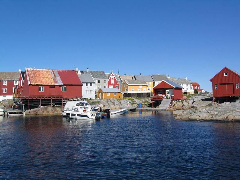
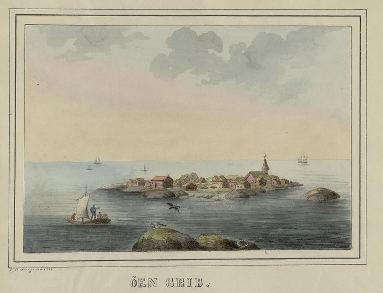
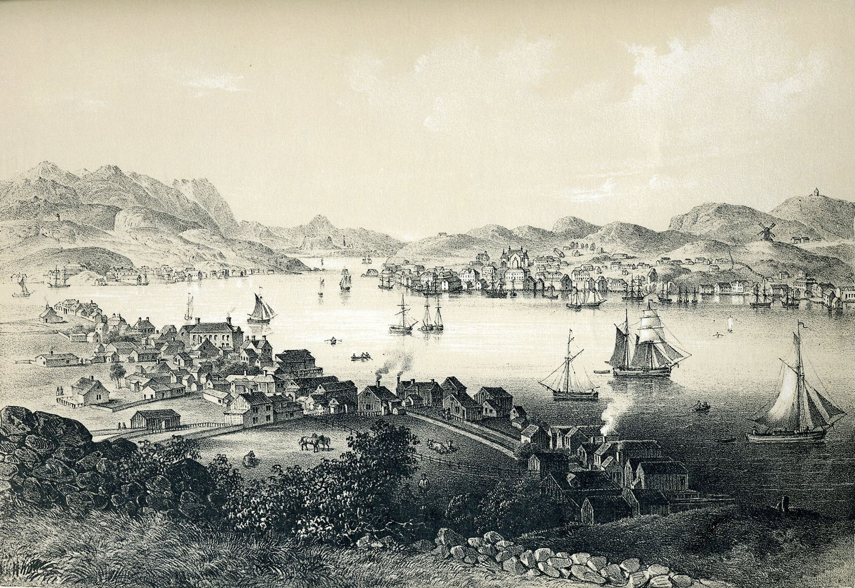


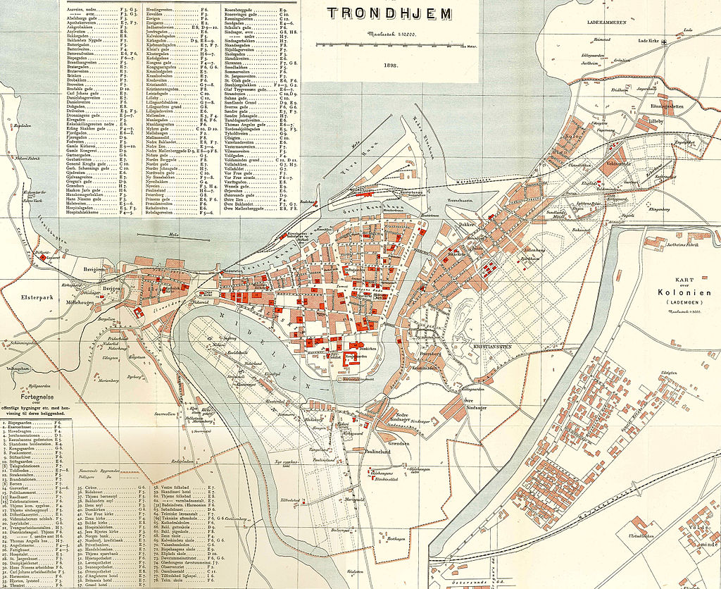


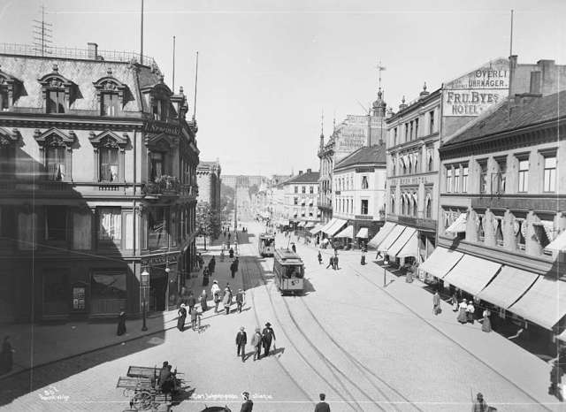
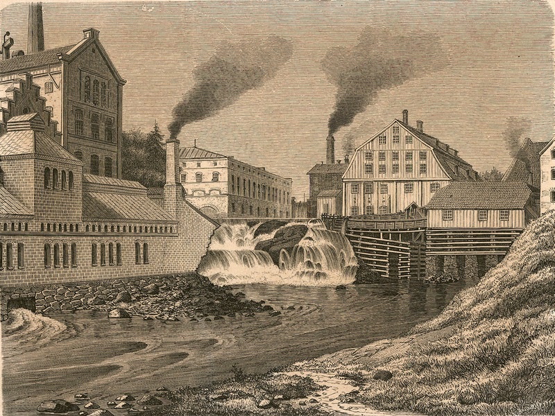


