Drive it Yourself: Hardangervidda Tourist Road

In this article...

Watch on Youtube

All of our roadtrips are available on YouTube to watch. They include information about the area provided in text and voiceover form, plus they show the drive in full (sped up in some spots!) so you can get an idea what the drive is like. 

The drive: Hardangervidda Tourist Road

Eidfjord

This drive begins in Eidfjord. You can find a detailed guide to Eidford below. 

Eio River & Eidfjord Lake

Natural Attraction

The river is 2.1km (1.3 mi) long and runs from lake Eidfjord down into the Eid Fjord. We’ll see the Eidfjord Lake soon; it’s a moraine-dammed lake located just outside the village of Eidfjord.

Øvre Eidfjord

Village

Øvre Eidfjord is a small village on the southern end of the Eidfjord Lake. The town has a population of around 200 and it serves as the last major stop before crossing the Hardangervidda Plateau.

Norsk Natursenter

Museum

Øvre Eidfjord is home to the Norsk Natursenter, which is where you can learn about the nature in the area. Technology is used to allow for interactive experiences and learn about the flora and fauna of the area. There’s also a lovely film about the plateau made by Ivo Caprino. If you have the time, I recommend stopping here to learn a little more about Hardangervidda.

Måbødalen

Natural Attraction

Måbødalen is a unique and narrow valley that will take you from Øvre Eidfjord to Hardangervidda. The deep and steep valley is the result of ice and water having cut into the slacker and more open valleys. The valley is studied with regards to its geological process and the interaction between ice and rivers.

The valley was almost impassable before 1790, when bridges were built, and a stairway was completed. The first road was built here in the early 20th century; it opened in 1916 and included three bridges. The road is known for its hairpin turns, and today is only for cyclists and pedestrians. The original road through the valley was the first road between east and west Norway over Hardangervidda.

Luckily for us there is now a new road; the new road is from 1986 and is wider and has many more tunnels.

Johan Christian Dahl painted Måbødalen, a landscape painting that is on display at the KODE art museum in Bergen. It’s pictured above. 

Before you get to the more dramatic part of the valley, you’ll pass a small museum about the cultural landscape of Måbødalen.

Vøringsfossen

Natural Attraction

Vøringsfossen is the 83rd highest waterfall in Norway, which itself isn’t an impressive statistic. Rather, it is the setting that makes Vøringsfossen worth seeing. The waterfall has a total drop of 182m (597ft) and is perhaps the most famous waterfall in the country.

The waterfall was hardly known to anyone besides the locals until 1821, when professor Christopher Hansteen estimated the height of the waterfall. He was on his way to Hardangervidda to make astronomical observations at the time. The way he estimated the height was by throwing stones down the edge and measuring the time they took to fall with his pocket watch. He estimated the height to be 280m (920ft); in 1893 the real height was realised by using string.

In 2020, a new pedestrian bridge opened across Vøringsfossen; it was placed in sections by helicopter. The pedestrian bridge has received a lot of criticism, which many describing it as quite ugly.

Fossli Hotel

Hotel

Fossli Hotel is a historic hotel overlooking the Måbø Valley and Vøringsfossen waterfall. The hotel was built by Ola L. Garen (1857 – 1915), who saw the potential of the area and the slow introduction of tourists. Before the hotel, there was only a walking path up the valley with 1,500 stairs. Thanks to the hotel, a new road was built through the valley instead. All the materials to build the hotel had to be carried on horseback from Eidfjord up to the top of the hill. Today the hotel is run by Erik Garen, the great grandson of Ola Garen.

Fossli Hotel is built in the art nouveau style.

The hotel owns a Zimmerman piano where Edvard Grieg composed Norwegian Folk Songs, Opus 66.

Room rates

Hardangervidda Plateau

Scenic Area

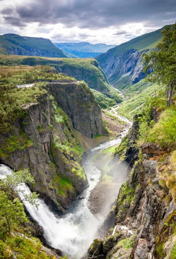
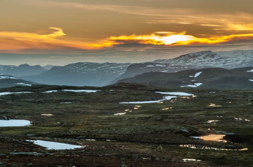
Hardangervidda is a well-known mountain plateau that spreads across parts of western, central, eastern, and southern Norway. It is the largest plateau of its kind (peneplain, or eroded plain) in Europe, and it has a cold year-round alpine climate. The highest point is the Sandfloegga, which reaches a height of 1,721m (5,646ft).

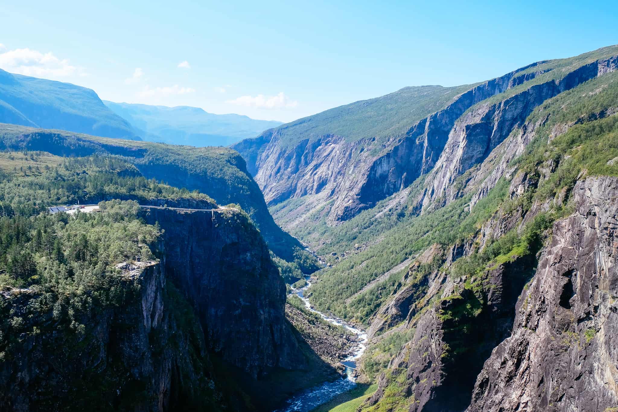
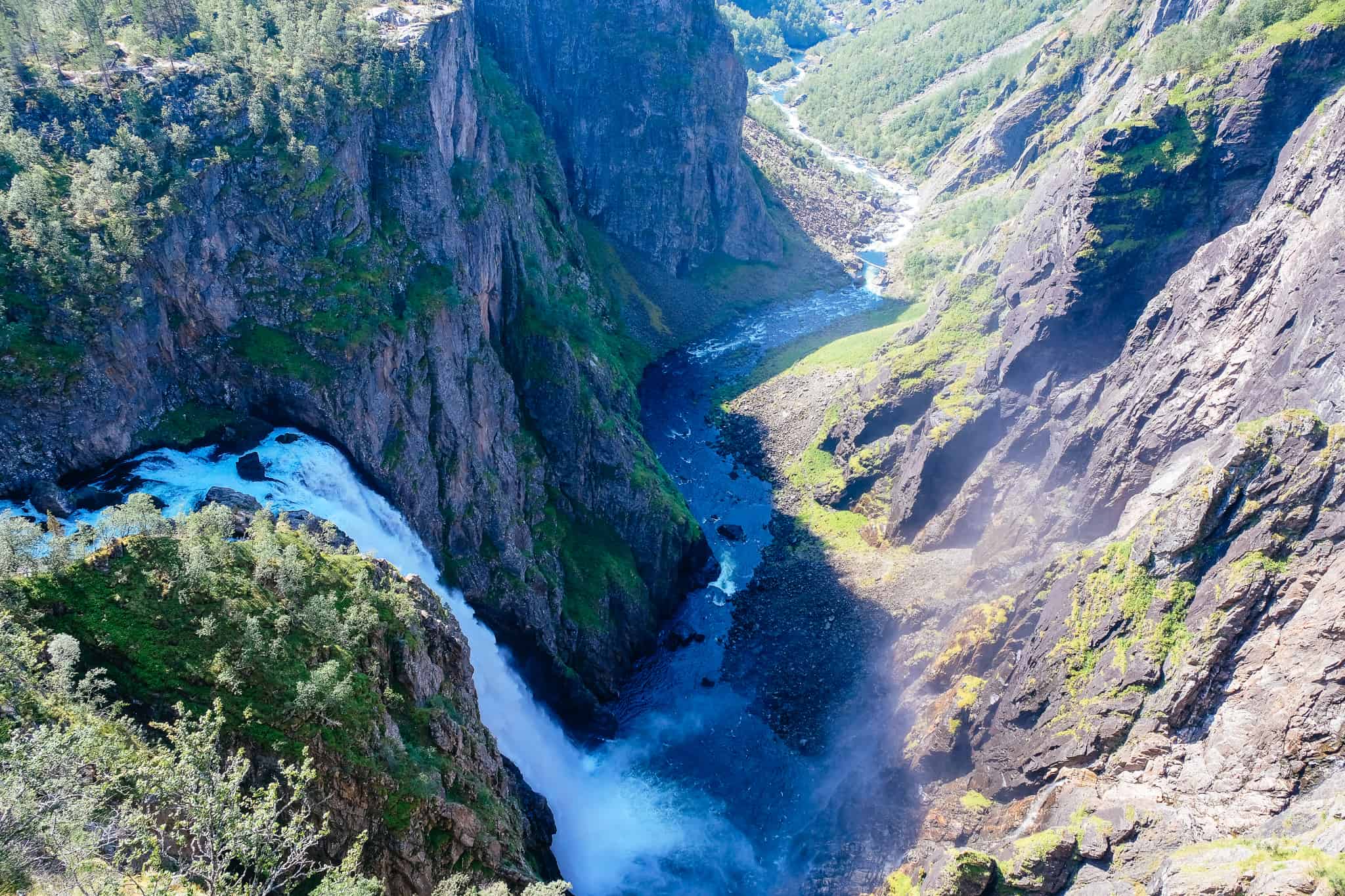
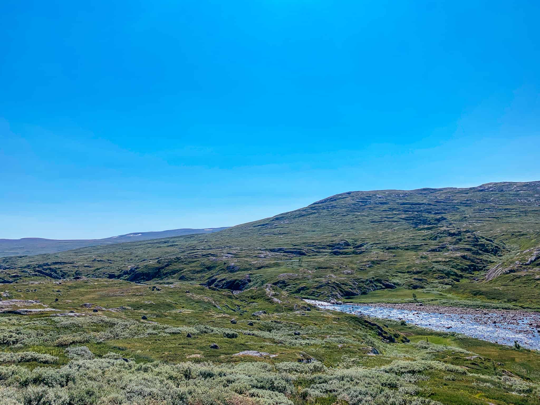
The landscape is characterised by barren, treeless, moorland with lakes, rivers, and streams. The western side is rockier, while the eastern side is flatter and more heavily vegetated. The geology is extremely ancient; the rolling fells are remnants of mountains that were worn down by glaciers during the ice ages.

Settlements from the Stone Age have been found in the area. The people who lived here were likely linked to the reindeer migration. Additionally, there are ancient trails across the plateau. Hardangervidda is still a key route between east and west; highway 7 being the way across.

The Hardangervidda Plateau is above the tree line. The alpine climate means that there are arctic animals and plants here further south than anywhere else in Europe. There is a large wild reindeer herd here; it is believed to be the largest in the world with up to 10,000 reindeer.

In 1981 much of Hardangervidda was designated a national park. The Norwegian Mountain Touring Association (DNT) has a network of huts and paths across the plateau. There are two visitor centres: the Norsk Natursenter in Øvre Eidfjord and the Hardanger Nasjonalparksenter, close to Rjukan.

The Star Wars movie, The Empire Strikes Back, was shot on Hardangervidda; the plateau provided the basis for the Hoth sequences.

Sysendammen

Dam

Sysendammen (Sysen Dam) is a rock-filled embankment dam. It holds back Lake Sysen, which is the main reservoir for the Sy-Sima Hydroelectric Power Station. The water supply to Vøringsfossen is regulated by the dam, and there is a requirement for a minimum water supply during the summer.

The dam is 81m (266 ft) high, 1,157m (3,796ft) long and 248m (814ft) wide.

Buskerud (Formerly known as Viken) County

We have crossed into the county that from 2020 – 2022 was known as Viken. At time of writing, the Viken sign was still by the road. This sign may not be up when you drive through; the county was established in 2020 with the merging of three separate counties. However, the three counties were not happy with the decision and in 2021 a parliamentary election saw the parties wanting to dissolve Viken win. On the 23rd of February 2022, a vote of 49 against 38 saw the decision to split Viken finalised. So, in the near future, Viken will be split up again. For purposes of this video, I’ll talk about the county that used to be here and will likely come back: Buskerud.

Buskerud county is a historically important county in Norway. The area around Ringerike was likely a small kingdom and Norway’s kings Olav Tryggvason and Olav Haraldsson grew up in Ringerike.

The first element of the name, buske, refers to ‘bishop’, while the last element means ‘clearing, farm’. Historically, the bishop’s farm was one of the largest in Buskerud and was important during the Reformation. The farm became property of the Danish Crown and served as the residence for the king’s bailiffs until 1668.

Agriculture, lumber, wood-pulp mills, and other related industries are the county’s main economic activities. There is a lot of hydropower thanks to the rivers Begna and Rands. Buskerud also has a large, forested area.

Hol Municipality

Hol is a mountainous municipality that sees 90% of the area over 900m above sea level. The coat-of-arms depicts three silver anvils on a blue background. The anvil was chosen to symbolise the former smithies in the municipality. The municipality was famous for the production of axes, blades and knives, and iron mining took place here in the Viking Age.

Samegammene

Souvenir Shop

Samegammene is a small shop and fur company that began sixty years ago, when Amund Johansen from Northern Norway was forced to sell his reindeer herd after World War II and move south. He took his family with him and settled in Hardangervidda, where he was given the job as a reindeer herder. However, he sustained an injury from that work and decided to focus on tourism instead.

Several ‘gamme’ have been bult around Hardangervidda. A ‘gamme’ is an ancient form of an earth hut, and from these they sell Sami products and souvenirs. Here you will find souvenirs but also handmade fur mittens and hats. The building was owned by the daughter of Amund Johansen until 2017, when she sold it out of the family. The current owners keep the gamme in memory of Amund Johansen.  

Haugastøl

Ski Town

Haugastøl is the first town you’ll visit after a while. It is primarily a ski resort with various hotels and cabins. There is also a train station here, Haugastøl station, which is on the Bergen – Oslo Railway.

Haugastøl is one end of the popular Rallarvegen cycling route – it’s an 83km track from Haugastøl to Finse (a town not accessible by road, just train). The road was originally a service road used by workers building the Flåm Railway, but now it is one of the most famous cycling tracks in the country. 

Ustaoset

Ski Town

Ustaoset is a small village located on the Bergen to Oslo Railway. The village came to prominence when the railway opened in 1909 as it was a good spot for people to visit to go skiing. Families from Bergen and Oslo built cabins in Ustaoset and used the train as a way to get there. Due to Norway’s strict laws, it is now very difficult to build a new cabin in Ustaoset. Whenever one is up for sale, it is very popular and is often sold very quickly and for a high price.

Ustaoset is mentioned in Jo Nesbø’s book The Leopard; the mountain resort cabins play a key role in the murder mystery.

Geilo

Ski Town

Geilo is the main town in Hol municipality and is one of the most well-known ski resorts in the country. The town is in the Hallingdal valley at roughly the halfway point on the Bergen to Oslo railway.

Geilo is noted for being the first ski resort in Norway and it was built up after the opening of the railway in 1909. The ski season lasts from late October until late April, and there are numerous small ski centres that make up one resort: Geilo Skiheiser. In addition to 39 downhill slopes, there are 220km of cross-country ski tracks.

In the town centre you’ll find some shops, a supermarket, and a few restaurants. Around 2,500 people live in Geilo all year round, so there is a school, cinema, library and police station.

Hagafoss

Village

Hagafoss is a small village in the upper part of the Hallingdal valley. It is located on the main highway between Bergen and Oslo, but here we take the Fv50 (Norwegian county road 50) towards Aurland.

Hol Gamle Kyrkje

Historic Site

Hol Gamle Kyrkje is a 13th century church in Hol municipality. The church was originally a small stave church but has been rebuilt multiple times. The last time it was rebuilt was in 1939, and today it doesn’t have the design that makes it a stave church. It’s believed the floors of the church are the original staves from the stave church. The church is also known for the fact that it has a gutter in the apse.

Vestland County

We have crossed back into Western Norway!

Aurland Municipality

Aurland is a municipality in Western Norway that includes the popular villages of Aurland, Flåm, Undredal and Gudvangen. It is also home to the UNESCO World Heritage-listed Naerøyfjord.

People settled here around 2,000 years ago to farm the area, and agriculture is still important in Aurland. Tourism began coming here in the mid-19th century, primarily from England. They took part in sport fishing and hunting.

The coat-of-arms depict a goat’s head; a goat is a symbol of the municipality because of their historic production and importance of goats cheese and goat farming.

Aurland Valley

Natural Attraction

Aurlandsdalen is a 40km (25 mi) long valley that was carved out by glaciers.

Aurlandsdalen represents some of the most beautiful and magnificent in Norwegian nature. The valley has been an important trade and traffic road from the ancient times and was probably in use from the early Viking Age. The route was the shortest route between western and eastern Norway in pre-historic times. There are a number of very old farms in the valley that were permanently inhabited until the turn of the 20th century. There are also mountain dairy farms here (called ‘støls’) that can be spotted high on the mountains.

The rare mountain flower “mountain queen” can be found in the valley. There are almost 500 plant varieties here. The soil is very rich in minerals formed from phyllitt in the rocks.

Today many use Aurlandsdalen as a popular day hike (6-7 hours), or you can hike all the way to Finse in 3-4 days. It is one of the best-known tourist tracks in Norway

As we went down, you saw the huge powerlines. The Aurland river system was developed in the 1970s for power production. The environmental impacts of hydroelectric development are notable; the great waterfalls have been substantially reduced. With the introduction of the tunnels, the water level in the river gorges has been drastically reduced. The Aurlands River is now no longer one of the finest salmon rivers in Norway. Farmers no longer drive cattle, pigs and goats to spend the summer at the old farms. The valley has been characterised, like many other valleys, by gradual urbanisation.

Aurland

Village

Aurland is a small village with a population of around 800. The village is the location of the Aurland Shoe Factory, where the famous penny loafers were first made. Another interesting place to visit in Aurland is the Vangen Church, a historic stone church from 1202.

Aurlandsfjord

Fjord

The Aurlandsfjord is a 29km (18 mi) long fjord and is a branch of the Sognefjord, the longest fjord in Norway. The fjord is deep and narrow, generally reaching less than 2km (1.2 mi) wide. Most of the mountains are up to 1800m (5,900ft) tall.

Flåm

We have arrived at Flåm, our final destination for this drive. Flåm is a small population with around 300 people, but is one of the most visited places in Norway thanks to the Flåm Railway. 

You can read the Flåm travel guide below. 

Next Drive

Flåm to Bergen

Flåm to Bergen on the E16

Follow the next drive as we make our way back to Bergen on the E16. 

Previous Drive

Voss to Eidfjord

Making a day trip out of Hardanger? Read about the stretch of road between Voss and Eidfjord. 

If you liked this drive, or if you have any travel tips, please leave a comment in the section below!