Emma

Hey! My name is Emma. I'm from Australia but have lived in Bergen, Norway, for the last eight years. I work as a local guide and tour leader for all over Northern Europe. The Hidden North is an online travel guide I have made to help you plan your own visit here.

  • Hananipa Hike

    Hananipa Hike

    If you’re in Bergen looking for a hike that is close enough you can do it in less than a day but also far enough that you can’t hear the hustle and bustle of the big city, then Hananipa is for you!

    Hananipa is not one of the famous Bergen hikes. In fact, I didn’t even know about it until one of my friends invited me to join her on the hike. As it had been months since I had left Bergen city centre (thanks, corona), I took the opportunity to go out and see some mountains and a fjord.

    The hike to Hananipa is gorgeous. You see the Sørfjorden, you see farms, fish farms, an old prison, small villages, sheep, and even snow in July! It’s a great taste of West Norwegian nature without having to venture far out into the wilderness.

    For this guide, I have tried to focus on including all the information I want to see when I’m planning a hike. Here we go!

    In this article...

    Is this hike for me?

    • Total length (beginning and ending at the train station): 13.8km (8.5 miles)
    • Types of path: First 4km (2.4 miles) is a road; last 2.5km (1.5 miles) is a rocky path
    • Steepness: First 4km (2.4 miles) is a noticeable but not steep incline; last 2.5km (1.5 miles) is a mixture – mostly it’s slightly steep (almost like walking upstairs) but it does flatten out towards the end
    • Safety: This path is safe – you never go close to the edge
    • Easy to follow? There are signs at the major turning points, but otherwise the path is unmarked. Still, though, you can see it clearly on the ground.
    • Populated? You will likely see other people along the way, but not many
    • Facilities: No toilets, shops or cabins along the way (including the train station)

    About the mountain

    Hananipa is a mountain peak located roughly between the villages of Trengereid and Vaksdal. The mountain is 718 metres (2355 ft) high, above the trees, and offers a panoramic view to the nearby island of Osterøy, the Sørfjorden, and the village of Vaksdal.

    About the area

    Trengereid is a small village about 18km east of Bergen centre. Trengereid has long been a farming community, well before industry came to the area. It was originally built up as an industrial village thanks to Johan Jebsen, who in 1895 founded Trengereid Fabrikker AS. Using electrical power from its own power plant on Manndalselva, the factory made various textile products. Operation ceased in 1987 and the power plant has since been taken over by BKK, the national power service.

    In 1920, the mountains around Trengereid began to be used for mining activities with the Risnes Limestone Quarry starting operations here. The mines provided jobs for 70 men, and the workers barracks were eventually placed with housing. The mines closed down in 1986 and since then no new business has been started in Trengereid.

    The population hasn’t decreased from this lack of industry, however, with the locals about to easily commute to Bergen city centre.

    Today Trengereid is a traffic hub with road and train connections to Bergen, the Hardangerfjord (Norheimsund), Voss and eventually Oslo. There is a primary school (opened 1896), a parish hall and chapel, and a daycare. Trengereid has a mixed choir with 30 members, and a music club. There are no shops or kiosks in Trengereid; the closest is in Arna.

    How to get there

    Take the train from Bergen Central Station to Trengereid. You can take the lines to Oslo, Myrdal or Voss, meaning that the train runs fairly regularly.

    The train journey takes 17 minutes. You do not need to request the train stop there; it always does.

    How do I buy tickets?

    Vy App – download the app called ‘Vy’; it’s in English so it’s easy to navigate. Select Bergen – Trengereid and your desired time.

    Cost: Around 66 NOK (varies depending on availability)

    At the Train Station – head to one of the ‘En Tur’ ticket machines and follow the prompts to buy a ticket.

    If driving, put “Skulstadvegen” into your GPS and follow the road up the hill. You’ll eventually come to a parking area on your right.

    Starting Point

    If you are taking the train, you will be starting from the train station – where I started too! The train station is around 3.7km from where the carpark is, and it’s all with a slight up hill (you will walk up 362 metres and it will take around 1 hour 20 minutes to get up there).

    If you are driving, you start from the carpark near the lake.

    Since most visitors to Bergen will be taking the train, I will begin the walk from the train station. Drivers, skip to the part with the car park!

    Part One: Train Station to the Lake

    Once off the train, cross the tracks. Directly in front of you, you’ll see a narrow staircase through the trees. The path is 150m long.

    You reach Vaksdalsvegen, a main road, and turn right. Then turn left onto Trengereidgeila. Follow the path as it curves to the right. You’ll then see a very narrow gravel path on your left – take that to get up to Skulstadvegen. If this road is too steep for you, keep following Trengereidgeila until you get to the main road Trengereidsvingane, turn left, and then take the next left onto Skulstadvegen. If this sounds confusing, Google Maps will take you on the exact same path.

    You will now walk all the way up Skulstadvegen – all 2.9km (1.8 miles) of it. The road isn’t steep, but you can feel the incline as you go up.

    Don’t be put off by this extra walk – Skulstadvegen is gorgeous, scenic, and a lovely walk. I got to eat some wild strawberries and look at the growing blueberries along the way. There are also many nice houses to look at. Here are some of my photos from the walk on the road:

    Eventually you’ll reach some farms with chickens and sheep (if you come in the middle of summer, the sheep will be up in the mountains). You will be walking on private property – that’s totally fine! – but you do pass through two gates that you can open but have to close.

    Eventually you reach Skulstadvatnet.

    Part Two

    When you reach Skulstadvatnet (the Skulstad Lake), you’ll see a sign about the local hiking trails. We are following signs to ‘Hananipa’. You can’t miss this point; the dam is right in front of you.

    Turn to the left and continue to follow the path along the left-hand side of the lake. This is where it will start to get rocky and narrow, but it’s never too steep.

    Eventually you’ll reach the other side of the lake, which is a nice rest stop before starting the next part. There’s a small stream there if you want to fill water bottles. There is also another sign pointing to Hananipa.

    Now comes the steepest part of the walk – you’ll be basically walking along the stream as you head up this wooded valley. The path is very narrow and it’s made up of rocks. Luckily it’s short – only a few hundred metres – so you can rest at the top where the trees end.

    Now for the last part of the walk:

    Part Three

    It takes around 30 minutes to get from the top of the valley to the mountain peak, so you really are on the home stretch. You’ll also be around 500 metres high at this point, so you’ve done most of the climbing! The trees are gone, and there are amazing views down to the Sørfjorden on your left-hand side. You’ll also the peak straight in front of you. It’s very grassy at the top, so the path is always pretty clear.

    You will soon pass a small cabin on your lefthand side. I’m not sure if this is a public or private cabin; when we went, we saw some tents next to it.

    The last little bit before the peak is a little steep, but it’s short-lived and you can see how close you are!

    When we went, there were plenty of sheep up there staring us down!

    What you see from the top

    If you walk a little bit past the peak you’ve been walking towards, you’ll see the stone marker indicating the top of the mountain. It’s from this point that you get incredible views out to Vaksdal and Osterøy.

    Vaksdal

    Vaksdal is a municipality in Western Norway with a population of around 3,977 people. During World War II, there was heavy fighting in the municipality as the German forces advanced along the railway line from Bergen towards Voss. The heaviest fighting took place in Vaksdal between 19 and 23 April. Three Norwegians and one civilian, as well as a larger, but unknown, number of German soldiers fell in the village.

    You can see the Vaksdal Mill from Hannaipa. When the mill was established in the early 1900s, it was the largest in Scandinavia. It produces grain and flour. It is an industrial municipality with 20% of the work in industry and 32% in construction, power and water supply. 26% of workers in the village commute to Bergen for work.

    If you are up there on a clear day (about as clear as I had it), you can see the Folgefonna Glacier and the mountains along the Hardangerfjord (you can’t see the fjord). In my photos, these are the mountains that still have snow on them. The glacier is fairly easy to spot as it’s a flat, white strip in between mountains.

    The Prison

    The island is called Ulvsnesøy and it has a lot of history for such a small island. It was probably first used as a monastic property, and later it became church property.

    In 1881, a boarding school for ‘bad’ boys aged 10 to 15 was established on the island. The institution was founded by Ole Irgens, Bergen’s school inspector at the time and ‘father’ of the Fjellveien trail in Bergen city centre. In 1900, the school was known as “Ulvnaes Lake School Home for Neglected Boys” and in 1951 it was changed to “Ulvsnesøy School for Boys with Disabilities”. The boys who lived there were sent by the authorities due to neglect of behavioural problems. In total, about 30 boys were there. The school closed in 1981.

    From 1982 Bergen used the island as a prison. At most, it had 31 inmates, 9 of which were women. The inmates were employed on the island, maintaining the buildings and farming. Farmers on the mainland could also use the prisoners as extra labour. The prison closed in 2019, was put up for sale, and the island sold for NOK 11.8 million. Whoever bought it has to use the island for business purposes, according to law.

    Going Back Down

    We took almost the same amount of time going back down, and that’s mostly because there are some rather large steps down that slows you a little bit.

    You do get some nice views going the other way, including the cabin we passed earlier.

    If the path feels confusing, you do see the lake in front of you all the way down, so it’s easy to navigate.

    The walk down the road back to the station was the toughest bit for me; it’s around that point that I started to feel tired. We checked the schedule for the train when we got back down to the lake – it took a little over an hour to get from the lake to the train station once we knew when the train was coming.

    Make sure you keep an eye out for Gullfjellet, the largest mountain on the Bergen peninsula.

    It has a flat, rocky top and is covered with snow practically all year round. In the photo, it’s the peak in the middle of the frame.

    When you reach Trengereid Train Station, head to the picnic benches and take a well-deserved rest! When we were there, and possibly very often, the station building is locked, so you will have to wait outside.

    Have you done Hananipa hike? Let me know in the comments!

  • Fjellveien Hike

    Fjellveien Hike

    No trip to Bergen is complete without a hike in the mountains – that is what Bergen is famous for! Still, though, hiking may not be for everyone, or you may have limited time for a hike. That’s where the Fjellveien hike comes in. Fjellveien is one of the most famous hiking routes in Bergen and what’s so great about it is that it is flat, making it perfect for all ages and fitness levels. By doing the Fjellveien hike, you get a lovely look at the Bergen mountains, forests, historic buildings, fjord, and cityscape.

    For this article, I walked the entire length of Fjellveien hike, making a note of all of the major points of interests along the way. I’ve also written down how to get to/from Fjellveien.

    In this article...

    Overview of the Fjellveien Hike

    Fjellveien (“Mountain Way” in English) is a path that goes along the mountains Sandviksfjellet and Fløyen in central Bergen. The trip starts at Munkebotn in Sandviken and travels through the suburb of Mulen, the city centre, and then into the expensive area of Bellevue and Kalfaret. The walk ends in front of the historic Bellevue Restaurant.

    Length and elevation

    In total, the length of the Fjellveien hike is 4632 metres (4.6km / 2.8 miles). It is probably the flattest hike in Bergen. The path is mostly a gravel path, though there are some sections where you have to walk on a road.

    In total, according to my Apple Watch, there was an elevation difference of 133 metres across the entire length.

    Time to allow

    Walking the entire length of the Fjellveien hike took me 80 minutes – and that includes stopping a lot for photos and venturing off onto detour paths. You could do it in under an hour if you are in a hurry, or even quicker if you jog the entire length.

    You can do the walk in either direction. Sandviken – Bellevue worked for me, but you can start from Bellevue. I’ve included how to get to both starting points in the next section.

    Getting to Fjellveien

    For my walk, I started Fjellveien on the Sandviken end. You can start on the Kalfaret end, but I found starting at Sandviken a little easier, a prettier direction, and then Kalfaret was easier for me to get back to the city.

    Taking the bus

    To the Sandviken Start

    I took the bus from Bryggen. There are two bus stops (A & B) in front of the wooden houses. These are the buses you can take:

    • 3 towards Støbotn
    • 4 towards Flaktveit
    • 5 towards Åsane Terminal
    • 6 towards Lønborglien
    • 83 towards Øyjorden

    Buses 4, 5 and 6 are the most frequent. Some leave from Bryggen platform A and some leave from Bryggen platform B. All take roughly 7 minutes / 5 stops to Gamle Bergen.

    The stop to get off at is GAMLE BERGEN (like the open air museum!)

    Once off the bus, head up the stairs and follow the road (Sandviksleitet) to the right. You’ll walk through a health centre (helse). Eventually the path will join with Munkebotn (it can be a little confusing; I used Google Maps to get there). Once at Munkebotn, keep following it (don’t go uphill; follow it to the right) until it splits into Fjellveien and Amalie Skrams vei.

    To the Bellevue Start

    The best bus that involves the least walking uphill is Bus 11 towards Starefossen. You can take it from Strandgaten (the stop right in front of the swan pharmacy), Småstrandgaten (close to the old city hall), or from Stadsporten (outside the old city gate). You get off at BELLEVUE, which is right at the beginning of Fjellveien.

    For the walk below, I start from Sandviken.

    Fjellveien Walk

    Beginning: Sandviken

    The walk starts along a very nice shaded path, where you feel like you’re walking in the woods. If you look between the trees to your right, you’ll see lovely views out to the city fjord.

    History of Sandviken

    Fjellveien was built in the late 19th/early 20th centuries by the Forest and Tree Planting Company (Bergen Skog og Taeplantningsselskap). Ole Irgens is often considered the ‘father’ of Fjellveien as he had a lot of input into its construction. At the time, Ole Irgesn was the school inspector of Bergen.

    Here are the stages (according to our walk)

    • Sandviken – Mulen: Built between 1901 and 1906
    • Mulen – Beautification: Built between 11879 and 1882
    • Beautification – Belleveue: Built between 1890 and 1894

    Permisjonsstein: Sandviks Battery Detour

    One of the first detour paths you’ll pass is the one that leads up to Sandviks Battery. It’s a little bit hidden as it’s not so much a path but rather an opening in the woods. The path to Sandviks Battery is relatively unknown; restorations have just been completed. (the local newspaper Bergens Tidende did an article about it here). The Sandviks Battery was built as part of Bergen’s inner fortifications in the late 19th century. Germans used it during World War II and built additional bunkers in the area. The name, “Permisjonsstein”, translates to “Permit Path”. When the soldiers were granted permission to leave, they would take this path down to Bergen.

    Sandviks Battery closed in 1952.

    Sherpas came to restore the path in 2019. They brought in their own equipment and worked to build stone stairs on the path. The path to Sandviks Battery has around 220 steps. It starts out flat, but gets steeper towards the end. If you walk slowly, it’ll take 15 minutes to get the top.

    If you want to do a detour to Sandviks Battery & Stoltzekleiven, see this walking overview (external link). Allow another 1.5 hours to complete this. Click here.

    You can watch a video of the hike up here.

    Old Hydro Plant

    The next point of interest is on your left; this abandoned building looks to be a hydro plant. The sign above the door says “BKK”, which refers to the Norwegian power company Bergenshalvøens Kommunale Kraftselskap. They have 29 hydroelectric plants throughout Western Norway. This building is a transformer station from the 1920s. Its connection to a nearby waterfall follows the old Stoltzekleiven route (see below).   

    Stoltzekleiven

    Stoltzekleiven is a well-known and popular hike amongst locals. In total, the hike has 908 stairs to the top. The elevation is 301.44 metres, the length is 834 metres, and the average elevation is 36%. It is quite a narrow path, and hikers are recommended to walk up only; heading back down via other nearby trails.

    The original trail was part of the Stoltzegården Farmstead; the name “Stoltz” comes from the German family that settled here. Gerhard Stoltz (1833-1907) was a German merchant who took over the farm Frydenlund (located at Gamle Bergen) and made it his year-long residence, renaming the property. He planted the shrubbery area up the mountain. The trail was laid out in 1900 over the old herding path. The spruce and pine trees we see are from 1870.

    Every September is the Stoltzekleiven Opp race. The event runs over two days from 9:15am to 6:15pm and runners go up every 10 seconds. On average, 6,300 people register for the event.

    The current record for men is held by Stian Øvergaard Aarvik (a professional mountain runner) with 7 minutes and 46 seconds. For women, it is held by Kristin Størmer Steira (a cross country skiier who has represented Norway at the Winter Olympics) in 9 minutes and 35 seconds. It takes me 30-45 minutes to do the hike.

    If you want to detour up Stoltzekleiven, walking down is discouraged. The path is too narrow, and locals only walk up.

    You can come back down via Munkebotn (where we started after the bus stop) or Skredderdalen (see further along this walk). You can also walk to Fløyen from the top – this is the easiest but longest walk.

    In 2011, Stoltzekleiven was refurbished with the help of Sherpas.

    White Manor House

    The white house you see here is the Bergen Skipperforenings Skipperhus, or the Bergen Skipper’s Association. The building dates to 1919 and maritime captains from the surrounding area make up the association. A retirement home has also been in here (see marcus.uib.no). In a recent newspaper article, the building has a market value of 43 – 51 million NOK.

    In front of it is another large house with a green tower and orange ceramic roof. Dating back to 1885, this building functioned as a retirement home for factory workers. From at least 2014, it is accommodation for students with a total of 37 apartments in the building (see this newspaper article).

    Christinegård

    Mon Plaisir is a pavilion from the old Christinegård Estate, who owned this property. You can’t see the house from here, but it’s directly below us.

    Christinegård is a “pleasure farm” (kind of like a holiday house) that dates back to the late 17th century. Christine Caspersdatter Middeltorp had the property built after her wealthy merchant husband died in 1694 and left her with a large sum of money. Very little is known about this first home.

    When Christine died in 1706, her daughter inherited the property. She passed it onto her son, Berent Madzen Chairman, whose wife Modesta Hansdatter Chairman, took over the property in 1747. She had the house rebuilt in 1763 with the main facade facing the fjord. According to the fire regulations of 1766, the property had a farmhouse, covenant dwelling, barge, barn and stables. Modesta’s son, Hans Berentsen Chairman, took over the farm in 1783.

    After the death of Hans, Christinegård was sold in 1822 to Dutch Consul general Michael Djurhus Prahl (1781-1851), who had the house completely rebuilt in the 1830s. The new building was two storeys and had the same position as Modesta’s, with the front looking out to the fjord. It was surrounded by a bastion, making the property look like a fortress.

    The front of the house has six pillars and a large porch, and there are window shutters on all the windows. This style gives it a very southern feel.

    Originally the property extended all the way up the mountain, but when Fjellveien was constructed in this area, it cut right through Christinegård’s property. Most of the land was sold off in the 120s to build apartment buildings.

    Christinegård was listed for protection in 1927, and between 1934 and 1958 it was the residence of the bishop. During World War II, Bergen’s commissioner-in-charge held Christinegård, and he held municipal funds in the building. Archaeologist Asbjørn Herteig, known for his work in the Bryggen excavation, took over Christinegård in the late 1950s and his descendants own the property today. It is not open to the public. On Google Maps, the house is now listed as a gallery:

    https://www.gallerichristinegaard.no/

    Mon Plaisir

    Mon Plaisir was built in 1836 for Michael D. Prahl, and ‘mon plaisir’ means ‘my pleasure’. The wooden building is shaped like a small Roman temple. In the photo above, you can see the fortress Sverresborg, built in the late 10th century by Sverre Sigurdsson during the Norwegian civil war. Just behind it is the church on Nordnes, Nykirken. The pink building to the front right is a high school

    The City of Rhododendrons

    The next little section of path has some lovely rhododendrons, which will be in bloom in May/June.

    Once you get past them, be sure to turn back around and you’ll see a sign dedicated to the rhododendrons.

    Mulen River & Water Plant

    Muleven is a river that flows down the mountainside. Originally, it would’ve gone all the way down to the fjord, but today it flows through pipes from Fjellveien downhill. The name refers to a number of mills that were established on the river to make use of the power of the stream for electricity.

    Until 1877, this was the city of Bergen’s northern boundary. This is also the point where Sandvik Mountain (Sandviksfjellet) becomes Fløy Mountain (Fløyfjellet).

    In 1876, the mills and water rights were purchased by the municipality, and four of the five mills were demolished, while the one remaining was in operation until 1912. The municipality planned to use Mulelven for both water and electricity. Mulevannverket (Mule Water Plant) was established to provide the local community with water in homes. Mulevannverket had the ability to supply the whole city with water if the main water plant at Svartdiket was to malfunction.

    Eventually Mulevannverket was taken out of use. Since 1997, Mulelven has not been a source of drinking water.

    It is possible to walk up the path you’ll see in the image to the left of the building. If you walk up there you’ll be able to see Mulelven. I didn’t go too far as I felt the gravel was slippery. You can certainly hear the river, but my photos don’t do the view justice.

    Skredderdalen

    This is also the beginning point of the hike Skredderdalen. Skredderdalen is a steep hike that is seen as an alternative to Stoltzekleiven if you want to get as high but do something a little easier. As you make your way up, you’ll pass the old damn built for the waterworks. The path will lead you to another path that will take you to Fløyen (See the hiking information here). It can also be a path down if you want to go up Stoltzekleiven. Here’s a link to that path.

    Mulen

    We are now in the residential area of Mulen, located between Christinegård and Bergen city centre. The name comes from the mill operations that took place along the river. It’s believed there was a farm here in the 1300s and that livestock were kept on the hillside.

    Inner City Views

    We are now in the city centre of Bergen, where below us will be Bryggen. It’s not visible from the path, though. For a short portion of the walk, you’ll be walking on a road as you cross through the suburb Breistølen. Fjellsiden is a residential area just above Bryggen. It was developed in the 19th century as the city was in desperate need of more housing due to a huge increase in the population. These wooden houses were built in a uniform grid pattern and were apartment buildings. The apartments were tiny; often they’d have one room and may have up to 12 people!

    Today Fjellsiden is a very expensive area of town. Some of these houses are now single residence buildings, but many are still tiny apartments.

    Hesten Trenger Hvile

    The main interjunction that links Fjellveien with Bergen city centre and Fløyen is called hesten trenger hvile, or “horses need rest”. There is a small fountain here as well as a statue of Ole Irgens, the ‘father’ of Fjellveien.

    From here, there are two paths you can take. The first is Tippetue, which is a scenic walk up to the top of Mt. Fløyen and the top station of the Fløibanen. The second is a path down to the city centre; ending somewhere near the Fløibanen lower station.

    Tippetue

    Why the name Tippetue? Well, Tippetue was a town local who lived in Bergen in the last half of the 19th century. He frequented the pub and had outrageous behaviour when he was drunk, so the locals called the area Tippetue. In 1908 the road was finished from Fjellveien to Tippetue, and then a few years later the road was extended up to the top fo Fløyen. (source)

    The walk up to Fløyen takes around 45 minutes and, while Tippetue is the steepest path to Fløyen, I’d say it is easily the most scenic.

    Regarding the walk back down to the city, this can be a way for you to get back to town when you’re finished with Fjellveien if you don’t want to take public transport.

    Skansemyren funicular station

    Not too long after the Tippetue junction you’ll cross paths with the Fløibanen. The stop is called Skansemyren, which is named after the residential area. The area is approximately 180 metres above sea level. There are many homes and apartments here.

    Skansemyren is best known for its communal sports ground, with different training activities taking place here. It is also home to the Tine relay race, which is held every year. The sports ground opened in 1896 with Ole Irgens at the forefront of operations.

    The Fløibanen opened in 1918 as a funicular between Bergen city centre and Fløyen mountain. If you are here on a busy summer day you won’t have to wait long to see the funicular; it runs every few minutes. Be sure to wave!

    From here, Fjellveien turns into a car road and remains this way for the rest of the walk. You’ve also got to be a little careful as there’s two roads in the area: Fjellien and Fjellveien – be sure to stick to Fjellveien.

    Bergen city centre

    The mountains you see (from left to right) are Løvstakken and Damsgårdfjellet. On the far left in the image, you can see the black skyscraper building that is the Bergen Media City. Next to it is the county administration building. Front and centre, towards the bottom of the frame, is the Bergen train station (look for the granite building). To the right is the Lille Lungegård Lake (you can learn more about the lake with my Årstad walking tour) and behind that are the KODE art galleries. To the right you can see the tower of St. John’s Church.

    If you walk along Fjellveien a little further, you’ll get more excellent views down to the city.

    Mt. Ulriken

    This is why I think doing the walk from Sandviken – Bellevue is nicest; you get this amazing reveal of Bergen’s largest of the seven mountains, Mt. Ulriken. Mount Ulriken is 633 metres high and is characterised by its TV tower on top. There is a cable car that will take you to the top of Mt. Ulriken, and it’s also a popular (but difficult) hike.

    Forskjønnelsen (Beautification)

    Beautification is a scenic zig-zag road and park that leads from Kalfaret up to Fjellveien. It was designed as a park in 1799 and has some lovely old villas close by (see my Årstad Walking Tour where I cover this in depth). It was formerly known as Lassens Minde (Lassens Memorial) after the parks designer, Customs Inspector HM Lassen, who also had the bushes and trees planted.

    This is a way back to the city if you wish to use it rather than take a bus back. If you head to the bottom you’ll end up on Kalfvarveien; turn right and you’ll see Stadsporten (The City Toll Gate). A couple minutes walk from there is the Bergen Train Station.

    Kalfaret

    Kalfaret is a suburb just outside the city centre of Bergen and was ‘the country’ (i.e. not part of Bergen) until 1877. The name comes from Calvarieveien (Calvary Road) and refers to the old Catholic tradition of walking around a road that is 1200 steps in length on Good Friday. This is approximately the distance from St. Jacobs Churchyard (next to Stadsporten) up to Kalfartoppen, the highest point in Kalfaret (this is the first portion of the walk we’ll take).

    Starting in the 18th century, a number of country houses were built along Kalfarveien. At the end of the 18th century, a row of Linden Trees were planted along the road, and gradually it was turned into a promenade that became a popular day trip walk with a number of restaurants and cafes along the way.

    In the 19th century, wealthy citizens began to move out of the city centre due to overcrowding and had lovely villas built along the mountainside in Kalfaret. Since then, Kalfaret has been synonymous with ‘wealthy Bergen’.

    Today a lot of the country houses are gone or have been significantly converted, and the large gardens have been filled with modern apartments. Still, we will be able to see some of the old villas from the late 19th century, and there’s also great examples of the Bergen-style houses.

    Bellevue Restaurant

    Lyststedet Bellevue has been a restaurant since 1976, when a gazebo was built here. A prospectus from 1801 shows a midmarket house on the site. It was rebuilt in 1899 as a restaurant, and has been a restaurant ever since. It is typically used for weddings and other celebrations. In earlier times, salutes were fired upon guests’ arrival.

    Today Lyststedet Bellevue is run by Bellevue Restaurant AS, which also runs Fløien Folkerestaurant and Bryggen Tracteursted.

    The business went bankrupt in 2016 and was transferred to another company. As of 2020, their website isn’t live (see here) and the Bellevue Restaurant AS company doesn’t list it on their website.

    Bellevue Restaurant marks the end of our walk!

    How to get back to the city

    Walking

    If you want to walk back to the city, you can follow the Fjellveien hike back to Beautification (if you want to be closer to the train station) or the Tippetue junction (if you want to be closer to Bryggen). You can also take Endregårdsbakken (just after Beautification) to get to the city centre. It will turn into Brattlien and that road will end just above Korskirken.

    Take the bus

    • Walk down Bellevuebakken (it’s to the right of the restaurant if you’re looking at it from Fjellveien).
    • When you reach Gamle Kalvedalsveien, turn left.
    • On your right will be a path down to the main road, Kalvedalsveien. When you get to the bottom, turn right. Shortly on your side of the road will be a bus stop.
    • Take Bus 3 to Støbotn for 8 minutes (6 stops) and you’ll be at Bryggen.

    I hope you enjoyed this walk! As you can probably tell by the amount of photos I took, I loved it. I think it’s a great option for anyone in Bergen who wants to see a lot in a short amount of time. You get a perfect blend of nature and cityscapes, and the walk itself is pleasant.

    Enjoy Fjellveien!

  • Trying Lefse in Norway

    Trying Lefse in Norway

    One of the most requested foods I get as a tour leader in Norway is lefse. It’s something everyone has heard of and wants to try when they come to Norway. Where do you even find lefse in Norway? Is it common to buy? I set out (for research purposes) to try different types of lefse in Norway and report back with which lefse to buy.

    First, though, I took a look at how Norwegians view lefse.

    In this article...

    What is lefse?

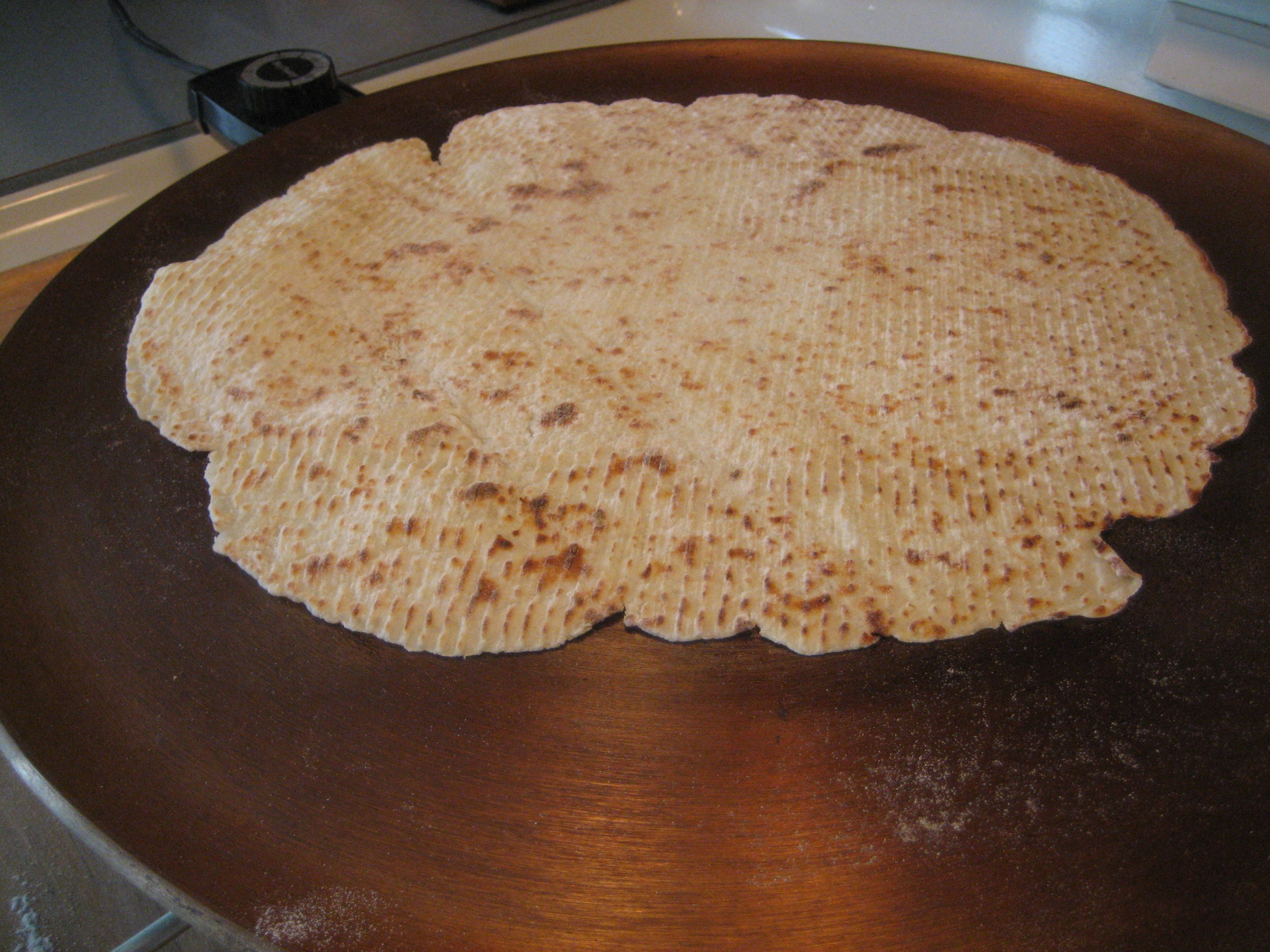
    Lefse - Wikipedia Lefse is a type of Norwegian flatbread that is often (but not always) made with potatoes, flour, butter, and milk. It has a similar texture to a thin pancake and is often eaten with butter, sugar, cinnamon or brown cheese on. Norwegian-American variations may add peanut butter, corn syrup or ham and eggs. More on that later.

    It’s important to keep in mind that lefse is not flatbread. Sometimes we use it like a flatbread, but there is also a separate Norwegian flatbread (see here)

    Although lefse has so few ingredients, recipes amongst Norwegian and Norwegian-American recipes vary considerably. Each family claims to have the best recipe there is. This makes it tricky to decipher exactly what kind of lefse you should try – flat or thin? Sugar or salmon? Brown cheese? Rolled up or flat? There are so many options. It’s especially tricky when trying to figure out what recipe can make. I can see why so many people stick to their family recipe.

    Lefse is very popular in the United States. Most importantly, in the Mid-West there is a large Norwegian-American population. Between 1850 and 1920, 800,000 Norwegians left Norway to go to the United States – at the time, the population was around 3 million people. Today, Lefse is probably more popular in the United States than it is in Norway. Therefore, Norwegian-Americans take the making of lefse very seriously. Their recipes vary from the Norwegian recipes; American’s tend to use potatoes as the main ingredient, whereas Norwegians tend to use flour.

    The history of lefse

    Norway has strong lefse traditions linked to the popularity of flatbread. Flatbread kept well, and sources from the 16th century say that it was soaked before eating. The oldest lefse was made from flour; when potato was introduced in Norway it gradually overtook flour, though not in all places. Flour wasn’t as commonly available in some parts of the country, where wheat doesn’t grow so easily, but potatoes were able to grow almost anywhere, making it a worthy replacement.

    Several lefse traditions originate in the development of flatbread into finer pastries. For example, in Helgeland, the lefse is decorated with a pattern before being fried a second time (see krinalefse). In Salten, the lefse is a soft flatbread with sour cream and brown cheese filling; the flatbread softens like a spoon when you gently fry it. As Norway was a very isolated country until recently, almost every region has its own version of lefse.

    There is a rumour that the Vikings made lefse, but this isn’t true. Potatoes arrived in Norway in the 15th century, well after the Viking Age. The Vikings may have had a flour version of lefse, but it was likely much closer to a flatbread than lefse.

    How to cook lefse

    The original lefse in Norway were made with barley and oat flours, and later they were made from rye and wheat flours. Most importantly, potatoes are used in some parts of the country, though it is much less common.

    Once the dough is ready, it is divided into balls and then flattened into thin circles – often the size of the griddle. It is then rolled with a special roller with square indents – see equipment below.

    Traditionally, the lefse was fried over an open fire, stone slab or iron plate. Today, electric griddles are used. Most lefse recipes follow the principle of flatbread baking. The lefse is placed onto the griddle with a special wooden stick. Some recipes use a pan, good to know if you can’t fit a griddle in your tiny apartment kitchen (my own experience!)

    Equipment

    Wooden Stick For example, in Wallendal in Bergen:

    Cost: 69 NOK (https://wallendahl.no/produkt/aanonsen-bakepinne-70-cm-flat/)

    Buying Online in Norway:

    Buying Online in the USA:

    Griddle Originally, my husband said griddles would be hard to find in Norway. Yet, in the very first store we checked in, we found one. Originally I was going to attempt to make lefse at home, but the griddle I found was way too big. We found it in Coop Obs:

    I think my husband was saying they were hard to find simply so we didn’t have to buy one! There are heaps online, just look for the word “steketakke”

    Buying Online in Norway:

    Buying a Griddle in the USA:

    Rolling Pin I did buy a rolling pin at Wallendahl for 199 NOK. They are easy to find:

    Buy in the USA:

    Lefse Kit Those in the USA are lucky because you can buy a lefse kit straight from Amazon that includes everything mentioned above. View it here: https://www.amazon.com/Piece-Lefse-Starter-Non-stick-Grill/dp/B00QXVUK3W/ref=sr_1_2?dchild=1&keywords=lefse+starter+kit&pd_rd_r=5668dc0e-8510-47a3-ad9a-392c200e97c3&pd_rd_w=Xmgxe&pd_rd_wg=1tzHh&pf_rd_p=ff875a9e-7810-43da-bae9-ec4c363817ac&pf_rd_r=DQ6HX6XG680C5WQ59VQF&qid=1592977565&sr=8-2

    Regional Differences

    When researching this article, I came across so many variations of what to do with lefse. It depends on either where you are, where you are from, or how you like your lefse.

    Moreover, traditional Norwegian lefse is smeared with butter, sugar and cinnamon. Some also use varieties of brown cheese.

    Lefse recipes vary across Norway. Here are some examples:

    Lokalmat - Snekalefse - smurt tynnlefse
    Tynnlefse (source: lokalmat)

    • Eastern Norway: Typically uses potato and the texture resembles that of soft bread. It may be used as a meal rather than a dessert, and it’s common to find salty toppings such as jam, sausage, and more. This is not common in other parts of the country. Potato was more commonly used here from the 19th century onwards and was also common in Sweden. It was essential for survival during times when the supply of grain was low. This
    • Central Norway: Tynnlefse is flour-based lefse that is rolled up with butter, sugar and cinnamon. (Recipe)
    • Salten in Nordland: Møsbrømlefse made from water, cheese and flour. (Recipe)
    • Nordland: Nordlandslefse is chunky lefse made of butter, syrup, sugar, eggs and flour. It was originally made in Western Norway as a treat to the Lofoten fishermen who arrived to trade their stockfish. (Recipe)
    • Hordaland: Anislefse resembles thin lefse but is stained by large amounts of aniseed. (Recipe)

    Eastern Norway

    Mørlefse (source)

    Western Norway

    Hardanger Lefse (source)

    Northern Norway

    Southern Norway

    Central Norway


    Lefse and the USA

    Lefse is very popular amongst Norwegian descendants in the United States and is commonly made and eaten around Christmas.

    Norwegian-Americans are more likely to make lefse from scratch than Norwegians are today. This is because the lefse-making tradition was brought over by Norwegians and it is seen as a way to connect to their heritage.

    Norwegian-American lefse is much more likely to be made with potatoes as many of the first Norwegians farmed potato and therefore made it easy to make lefse.

    https://www.youtube.com/watch?v=0xLlQ3ff2GM The USA is keeping the lefse tradition alive. There are classes on how to make lefse, lefse can be found in many grocery stores in the Mid-West, and there are even lefse factories! Some parts of the country even have lefse festivals, such as the Lutefisk and Lefse Festival in Fargo, North Dakota, the Lefse Fest in Fosston Minnesota, and Lefse Day in Mankato Minnesota. The Potato Days Festival in Barnesville Minnesota has a lefse cookoff.

    American Recipes

    American recipes are not as varied as Norwegian recipes, and most of the recipes I found use potatoes instead of flour.

    Here are some examples of recipes:

    Lefse in Norway today

    In Norway, lefse is a traditional food that is typically reserved for special occasions. It is not eaten that often in Norway. The only times I’ve had lefse is when I’m with a group; I’ve never had it with my family. My husband buys lefse maybe once a year. We’ve never made it, though I’m working on putting together my own recipe!

    There are lefse competitions in Norway. This is a competition overview from 2018, where the winner was Suldals Lefse and the runner up was Nordland’s Lefse. An honourable mention went to Sunnmørslefse, the only potato-based lefse mentioned. The recipes of the winners are on the website if you want to be guaranteed good tasting lefse.

    In general, lefse is a snack food you can buy from kiosks or it’s food taken when you go hiking. It is sometimes served at traditional dinners (e.g. Christmas dinner), but this is becoming less common.

    There are some really interesting Norwegian recipes that use lefse – if you want to go full Norwegian, you can make this Lefse with Lutefisk recipe. Honestly, I’ve only ever seen lefse as a sweet snack. The idea of adding fish seems foreign. But that’s just me – as we’ve learned so far, lefse preference differs greatly according to region.

    Here’s a Reddit thread of what Norwegians put on lefse today.

    Trying lefse in Norway

    Now for the fun part – where can you try lefse in Norway? For this bit, I ventured out to several supermarkets and collected up the different types of lefse I found.

    For the reviews I recruited my dear husband and local Norwegian, Sean. He is born and raised in Bergen and grew up eating lefse. I’ve lived here for four years and only eat lefse with tourists. Hopefully both of our opinions will help you!

    Vestlands Lefse with Sugar and Cinnamon

    Frozen Aisle (near the frozen breads) / 55 NOK for 6 packets of Lefse / Shop Link

    Ingredients: Plain flour, sugar, margarine, milk, salt

    Vestlandslefse is produced by Orkla Foods Norway and has its origins in Os, just south of Bergen. Production started in 1959 by Inger Bøe, and her son carried on the business. The business left Os in 2012 and is now in Stranda, Møre og Romsdal. It is closest to Møsbrømlefse, Krinalefse and Lefsekling. (See product website here)

    This is the lefse my husband buys every year and this is the one he stands by. It’s also one of the very few brands to be found in the frozen aisle. This is the first lefse I tried in Norway so it’s the lefse I associate the ‘proper’ taste with – I may be a little biased here!

    My Review: I found it a little soggy when first biting into it, but I was told by Sean it was because we didn’t let them defrost enough. I love the taste – it’s super creamy and buttery and cinnamon-ey – they don’t skimp on the ingredients. This is what I buy whenever I want a snack. It’s so so good. 4.5/5

    Sean’s Review: Most traditional tasting lefse (at least for the west coast) closest thing to what has been served traditionally in my family. Filling is excellent, with right amount of cinnamon and sugar added. 4.5/5

    Where to buy: Avaiable in all supermarkets. You can also buy individual packets at kiosks (defrosted).

    Klenning Lefse with Brown Cheese

    Near the fresh breads / 19 NOK at Kiwi / Shop link

    Ingredients: Plain flour / margarine / milk / brown cheese

    “Klenning” is a type of lefse found in Trøndelag, and the brand “Berthas” is likely what you’ll buy in stores as it is the clearly dominating brand in supermarkets. When it’s in a little packet like the one seen above, it’s often called “Turklenning”, meaning you grab it and take it with you on a hike (tur=tour in English).

    This lefse comes with small pieces of brown cheese from the cheese brand Synnøve.

    My Review: I love the brown cheese inside the lefse. It adds a really special sweetness to the bread, and there’s not enough brown cheese that it’s overpowering. I was really surprised by how good this was. 4.5/5

    Sean’s Review: Brown cheese sticks out, and like the potato lefse (below), sticks out since it is the only one on the list that has a unique flavor to it with enhanced sweetness in lieu of the more traditional cinnamon

    Klenning Lefse with Sugar and Cinnamon

    Near the fresh breads / 19 NOK

    This is the ‘normal’ version of the Turklenning lefse. It’s a standard lefse and in many ways similar to the Vestlandslefse above.

    My Review: It’s a fine, typical lefse. It’s lighter on the sugar than Vestlandslefse, and fairly forgettable (I originally forgot to include it in the article). It’s a safe bet for those who are unsure if they’ll like lefse. 3.5/5

    Sean’s Review: Nothing in this lefse that sticks out, or detracts, just ultimately a generic lefse. There is a variant with cinnamon that is preferred over this. 3/5

    Lefsegodt

    Near the fresh breads / 15 NOK / Comes with two pieces

    Ingredients: made with plain flour

    This lefse has a more sandwich texture; you can see in the photos above how much thicker it is compared to the other lefse I tried. It does look like it should have a cakey texture in some recipes I found online (see here), but this particular lefse is more bready. It takes inspiration from the “tykklefse” (see recipe here) On the packet you can see it says “Norske lefse tradisjoner”, meaning it is inspired by more traditional methods of making lefse.

    My Review: I found it to be too similar to bread, and the thickness of the lefse almost hid the butter and cinnamon underneath. I also found it to be very heavy; I don’t know if I could finish a whole one. 3/5

    Sean’s Review: Bland, and consists of mostly bread. Good snack if the goal is to fill yourself up quickly, but otherwise – pass. 2/5

    Buy on Norwegian food store

    Lefse roll made from potato lefse

    Near the fresh breads / 39 NOK at Coop supermarket / Shop link

    Finally, a potato lefse! This was the only one I could find in my local supermarket and I was eager to try potato-based lefse. On the packet you can see “en smak av Lierne”, meaning it was inspired by the lefse in Lierne, a region in Trøndelag in central Norway.

    Putting “Lefserull smurte potetlefser” returns many results for savoury recipes, including lefse with salmon and lefse with ham. The recipes look delicious, but it is something I would associate more with flatbread or tortillas. I may need to try making these recipes to see if it works.

    Now, onto what I thought:

    My Review: I really wanted to like potato lefse because it seems so popular in the United States, but I found this really hard to eat. I found the potato lefse starchy and really glue-like. However, there wasn’t really any flavour coming from a filling, so I was left with eating cold, dense potatoes. It was my least favourite of them all. 2/5

    Sean’s Review: Rubbery texture, bland taste. Stands out from the other lefse types since it is made out of potatoes. Cinnamon variant exists for this, would highly recommend over the generic non-spiced variant. 3/5

    Words to know

    Here are some Norwegian words you’ll come across when seeking out lefse:

    • Lefserull = rolled up lefse
    • Kanel = cinnamon
    • Potet = potato
    • Med = with (e.g. Lefse med kanel)
    • Tur = tour/travel. Often refers to small packets you take on a hike or little snack packs
    • Sukker = sugar
    • Brunost = Brown Cheese (the brand is Synnøve Gudbrandal)

    Conclusion

    I hope this article has been useful in discovering lefse in Norway, and hopefully you’ll be able to try some on your visit.

    Building this list: if you know another type of lefse that can be found in stores, please reach out to me so I can add it to my list!

  • A Guide to Gamle Bergen

    A Guide to Gamle Bergen

    For me, Gamle Bergen was one of those places I occasionally took groups, but never really understood. I never had the chance to go there myself, and when I was with tourists I was too busy with them. As a tour guide, I memorised information about the important houses, and always made sure to give them their maps and point them in the right direction, but that’s about it. I never understood why to make the journey to Gamle Bergen when modern Bergen is full of old houses!

    With the corona situation, I’ve had much more free time to go exploring, and it’s finally giving me the chance to build up this blog. I decided that I would visit Gamle Bergen and write about it for Hidden North, hoping to find some new appreciation for the museum. And boy, did I!

    So, for my Gamle Bergen Guide, I’m going to go over what you can see at the museum but also the hidden attractions around the museum because, honestly, they are just as special (and they are free!)

    In this article...

    What is Gamle Bergen?

    Gamle Bergen (English: Old Bergen) is an open-air museum located a few kilometres outside the city centre of Bergen. The museum was established to save the characteristic houses that represent Bergen architecture. Bergen did catch fire often!

    The museum’s founder was Kristian Bjerknes (1901-1984), a cultural historian and member of a group of likeminded locals. He became the first director of the museum and ran it until 1971. As the city was expanding at the beginning of the 20th century, the widening of streets led to the demolition of many of Bergen’s wooden homes. The museum group would instead take the houses and place them on their site.

    In 1944, a German freight ship exploded on the Bergen Harbour. The explosion damaged many wooden houses, and the museum sped up its efforts to save these buildings. They were rebuilt at Gamle Bergen.

    The museum has 32 houses plus smaller buildings and items from the old times. Gamle Bergen’s purpose is to highlight Bergen’s history and cultural life, with objects and information boards telling about what it was like to live in Bergen in the 18th and 19th centuries.

    Historic Overview of the Site

    Gamle Bergen was built on Elsesro, an old summer estate. The wealthy shipbuilder Rasmus Rolfsen had Elsesro built to accompany his boatyard. He named the site Elsesro after his wife Elsebe (Elsesro = Else’s Peace). In the 19th century, the pavilion, gatekeepers house, summer house, tower house and barn were added.

    Rasmus Rolfsen’s son, Tønnes Rolfsen, expanded the main building when he moved in. Damsgård Manor, which sits directly across the fjord, likely inspired the architecture of the building. Tønnes Rolfsen also had Haugen built, with its Chinese pavilion, park and ponds, designed in an English garden style.

    After Tønnes Rolfsen passed, his son Rasmus Rolfsen took over the property and continued using it as a shipbuilding business. The shipyard operations were ceased and the business was abandoned in 1839. Rasmus Rolfsen, on his travels to Copenhagen, had become interested in the liquor business and decided to use the property for that. The business didn’t last long; in the second half of the 19th century, the property was a paint-making business.

    When Rasmus Rolfsen died in 1903, he left no descendants. The city took over the estate in 1906. From 1911 to 1916, the property was used as an orphanage for children from tuberculosis homes. From 1919, the building was used as a nursing home for children with syphilis. The purpose of sending the children there was to isolate them to prevent infection as well as sure them. This home was abandoned in 1939.

    From 1936, the Gamle Bergen Association took over Elsesro in several stages, and in 1949 the museum opened with the first restored houses.

    I’ll go over the original buildings a little more on the walk-through.

    On the way to Gamle Bergen

    For my guide below, I walked from Bryggen to Gamle Bergen. Therefore, my walk starts on the opposite side of the park from the main entrance. Honestly, I found it a lot nicer than using the main entrance, which is on a dirt road. It’s much more peaceful using the side entrance as you pass these lovely historic homes as well as the old shipyards.

    The Ropemakers House

    The point in which you leave the main road to walk to the Gamle Bergen entrance begins at the recently restored Ropemaker’s House. This lovely 19th century home was the residence of the owners of the ropeworks you’ll see behind it.

    The area you walk through now is an area that has many historical monuments. Sadly it’s also an industrial area, so there’s a mix of history and then ugly modernity.

    Måseskjaeret

    Hidden amongst the industrial buildings is Måseskjaeret, a 1798 villa (lystgård in Norwegian) that sits out on the water. The building has been converted into modern warehouse buildings.

    Ditleffsengen & the Sailors Homes (Strandens grend)

    Ditleffsengen is another 18th-century villa we pass on our left.

    After this building, we pass a village-like cluster of old houses known as Strandens grend today. These were the homes of sailors as well as workers at the factories. They also signify the northernmost part of Sandviken.

    Holmefjordboden

    This building was built in 1804 for merchant Johan Ernst Mowinckel, who imported corn, textiles and other ‘kolonial’ products. For a while, this was also a stockfish warehouse.

    Masteboden

    Masteboden, or the ‘mast booth’ is part of the original Elsesro property; and is the long brick warehouse on the waterfront. It was the building that was built to repair the Russian ship. Rasmus Rolfsen repaired the ship, a task which took one year and 8 months. The building is probably the largest privately owned Empire-style brick building in Bergen.

    The Old Postal Road

    Just before the Gamle Bergen entrance, close to the gate there is the first leg of the postal road that ran from Bergen to Trondheim; the route can be followed for many kilometres into the hills above the modern street of Helleveien. At the side of it is a water mill which incorporates the vestiges of one fo the largest mill complexes of Old Bergen, Storemøllen, which began in the 16th century. It was torn down in 1971.

    Gunhilds River

    The brook, besides being a remnant of a once so forceful stream that propelled the giant wheels of the mill, is a historic landmark of the first rank. This is Gunhildåen, ‘Gunhild’s River’, which is mentioned in Bergen’s City Laws of 1276 as being the northern boundary of the city; from here the boundary ran inland far into the hills before turning southward.

    Today the river is called Sandvikselven (Sandvik River), and it comes out of a ravine called Munkebotn (The Monk’s Hollow). The name derives from the fact that in the Late Middle Ages the Dominican brethren in Bergen had property and mill rights in this area.

    Inside Gamle Bergen - the free part

    Now it’s time to go into Gamle Bergen. As we do, it’s worth noting that the park can almost be seen in two parts: there is a free part you can walk through (it’s very popular with locals) and see most of the buildings from there.

    There is also a paid portion of the park, and that consists of the famous ‘street’ and surrounds. During the summer months, the buildings in the paid portion of the park are opened up and you can step inside and view exhibitions. Additionally, they have actors representing people from the 18th and 19th centuries that you can talk to, and they give little demonstrations throughout the day.

    The paid portion of the park is only for the summer months, May to September, and outside of those months you can explore the paid portion of the park for free, however the buildings are closed up.

    Does that make sense? I think so. Let me summarise:

    • Free Park: Some buildings. Open all year
    • Paid Park: Best preserved buildings. Costs money between May-September with entrance into the buildings and exhibitions. Free off-season, but the buildings are closed.

    Now let’s do the free part of the park first.

    Elsero

    One of the first buildings you’ll pass is Elsesro, the original summer residence. The central part was built by shipbuilder Rasmus Rolfsen in 1785, while his son Tønnes Rolfsen added the two wings around 1810 to make it look more grant. Tønnes made the property into a miniature manor that was very popular at the time; he had the whole area landscaped and created dams and small waterfalls.

    Today Elsesro is a lovely Norwegian restaurant.

    The Park

    If you continue past Elsesro, you’ll soon arrive at the garden, which has been designed in the style of an English garden. This was a common type of park in the 18th century. To speak romantically, the English garden was to emphasise man’s rational and emotional sides. At the same time, the park was supposed to look natural.

    Today it’s the home of some ducks and geese.

    The Pavilion

    The pavilion was part of Tønnes Rolfsen’s expansion, and it was designed in a Chinese style. The view from the pavilion once inspired J.C. Dahl to paint one of the finest views of the hometown, but Edvard Grieg also found inspiration here. He borrowed the pavilion in 1873/74 to serve as his studio while writing the music for Bjørnstjerne Bjørnson’s play Olav Tryggvason and then for Henrik Ibsen’s Peer Gynt.

    While the pavilion is nice, it’s the view you come here for. You can see three of Bergen’s seven mountains, Sandviken, and the city fjord. On a sunny day, this view is everything. It’s easy to see why artists like J.C Dahl and Edvard Grieg would come here for inspiration of their city.

    If you walk along the park, you’ll see a lovely white manor hiding behind the trees.

    Frydenlund

    Frydenlund was built in 1797 for the wealthy merchant Lorentz Holtermann as his summer estate at Sandviken. The name means ‘grove of delight’ and became a major summer estate for himself and his family.

    The house consisted of Lorentz, his wife Anna Margrethe, their five small children, a housekeeper, four serving girls, a farmhand and three merchants clerks. Holtmann sold the property in 1832 and it was passed around by various wealthy merchants. In 1870 it underwent a major renovation. After the war, it had to be demolished to make way for a housing project, so it was moved to Gamle Bergen in 1949.

    Inside Gamle Bergen - the paid part

    Now let’s move on to the paid portion of the park. As mentioned above, you can go inside the buildings and see exhibitions there. I’ll try and get back later this year to take photos of the interiors, but for now, I’ll explain each building you can see.

    Let’s start with the so-called ‘main street’. I’ll go through the buildings in order as if you were walking up the hill and passing them.

    The Watchmaker's House & Sea Captain's House

    The watchmaker’s house (green) and the sea captain’s house (white) are located at the bottom of the hill.

    The Baker's House (The Yellow Building)

    The Baker’s House was built in 1728 to house, you guessed it, a bakery. Originally the building was one floor; the second storey and attic were added in 1788.

    This wasn’t just any baker’s house; this was the home and bakery of Master baker Ditlef Martens. His son, Nikolai Martens, ran the bakery from 1840 and the Martins family owned 11 bakeries in the city. Back then, the profession of the baker was a privileged status, and there could only be 25 bakers in the city.

    Nikolai Marten’s great grandfather, grandfather, father, brother, son, grandson and great-grandson were all master bakers in Bergen. This particular bakery was located just behind St. Mary’s Church. The bakery operated until the 1944 explosion.

    The Merchant's House (The Blue Building)

    The Merchant’s House is an example of a Norwegian merchant’s home in Nordnes; this building was located just behind Nykirken Church. Originally this building would’ve had a lovely courtyard, stone cellar, and washhouse. As Bergen became increasingly populated in the 19th century, this house was converted into a three-storey apartment building. In total, there were six apartments.

    Once at the top of the hill, you’ve reached the main square. I’ll go around the buildings clockwise from here.

    The House of Craft and Trade

    The home dates back to after the fire of 1756. It functioned as a residence until it moved to Gamle Bergen. It houses various artisan workshops, though it was originally a residence.

    Inside the building, you can see a printing press, bookbinding workshop, Bergens Tidende (Newspaper) office, plumber workshop, and photo studios with waiting rooms.

    The Glazier's House

    The home dates back to after the fire of 1756. It functioned as a residence until it moved to Gamle Bergen. It houses various artisan workshops, though it was originally a residence.

    Inside the building, you can see a printing press, bookbinding workshop, Bergens Tidende (Newspaper) office, plumber workshop, and photo studios with waiting rooms.

    The Town Hall

    This building was originally owned by the Solhimsviken Indremisjonsforening (Solheimsviken Evangelical Association), which used the hall as a chapel. Yes, this is a religious building! Doesn’t look like it today, right?

    When Solheimsviken was undergoing a major renovation in the 1970s, the chapel was expropriated, and then in 1977 Gamle Bergen was offered the building. The museum uses the hall for assembly events, so all the religious symbols have been removed.

    The House of the Official

    You can tell this was the house of the official. Back then, the most privileged houses were completely symmetrical; compare this to the merchant’s house, the baker’s, or the glazier’s house, for example.

    The House of the Official stood on Kong Oscars Gate (near the Leprosy Hospital/City Gate (Stadsporten). Carsten Lydkien, a customs agent and police prosecutor, lived here from 1795. The property remained a single-family home until 1914, something not many houses in Bergen can claim.

    Dentist's House

    This is another Nordnes building; in fact, it was the neighbour of the merchant’s house. It was a residence for a middle-class family. The building itself underwent a modernisation in the 19th century, getting a lovely new Swiss-style facade. The building is converted into a dentist’s home and surgery representing the period 1885-1900. Take a look at the dentist’s equipment if you can go inside. Thank god we live in the 21st century.

    There is also an umbrella business in the building, because Bergen.

    Dorothe Engelbretsdatters House

    Dorothe Engelbretsdatter is a well known Bergen priest and writer from the 18th century. She is the first known female writer in Norway.

    Dorothe lost her original home in the 1702 fire. As a priest, she had trouble building a new house and lived for a long time in a poor house. When King Frederik IV of Denmark/Norway visited in 1704, Dorothe handed him a poem and prayer letter and asked for his help for a new house. He didn’t help her. After she asked the city authorities in 1709 she got her house.

    The Grocer's Shop

    In Norway, grocer’s shops were referred to as ‘Kolonial Stores’ because they were where people would buy goods ‘from the colonies’. These shops started appearing in the 1870s, but it was not until the 20th century that this type of shop began to dominate the grocery trade. Back when the Kolonial Stores were the grocery shops, they were special local shops. Goods weren’t stored in people’s homes like they are today. Grocery products were bought in small quantities every day. It’s kind of like a ‘storeroom’ for the nearby houses.

    Krohnstedet

    Krohnstedet is a typical summer estate that appeared in Bergen in the 18th century. It was built for the wealthy merchant Hans Krohn. Hans Krohn ran one of the city’s biggest shipping companies that imported and sold wine. He had twelve children with four wives, and only six children survived to adulthood.

    The house is accompanied with by caretaker’s house, which was common at the time.

    Now make your way back to the main square. Once at the main square. You’ll see there is a path that runs in front of the sailor’s house. It’s a lovely secret path where you can see the backs of these old buildings. It will also take you back to where we began and marks the end of my little walk!

    Now onto the practical information.

    Practical Information

    Opening Hours

    Gamle Bergen is open from mid-May to mid-August.

    During mid-August to mid-May, you can still walk around Gamle Bergen for free. Just keep in mind that you can’t go inside the buildings.

    Getting There

    Walking

    Gamle Bergen is a thirty-minute walk from Bryggen. The walk is mostly flat, with some gentle inclines. It’s a lovely walk; you walk through historic Sandviken before turning off to reach the ropemaker’s house. For my above walking tour, I walked from Bryggen and took the back entrance from there.

    Bus

    From Bryggen:

    Take Bus 3, 4, 5, 6 from the bus stop in front of the wooden houses. The bus ride takes 10 minutes and the name of the bus stop is ‘Gamle Bergen’. Once off the bus, cross the road and follow signs to Gamle Bergen. This takes you to the main entrance, not my side entrance.

    Tickets can be bought via the Skyss App, on the bus (for 2x the cost of the app), or at a ticket machine.

    I hope you liked my Gamle Bergen guide 🙂

    Sources:

    Gamle Bergen brochure

    Nordhagen. Per Jonas. Bergen Guide & Handbook. Bergensiana-Forlaget. 1992.   

  • A Walk Through the Bergen Fortress

    Emma

    The Bergen fortress is located roughly between the cruise ship terminal and Bryggen, making it a very convenient place for visitors to explore. It is one of my favourite places to take to, simply because there’s so much history there. Everywhere you look, you hear about Kings, Armies, War and renovation. It’s incredible.

    If you’re in Bergen and want to walk somewhere that’s maybe a little quieter than the town centre, or you love history, the fortress is for you!

    On the 5th of May 2020, I went for a walk through the fortress and took some photos of all the buildings. I used the free museum guide that you can either pick up from Håkon’s Hall or the Rosenkrantz Tower, or you can download it online by clicking the link:

    https://www.forsvarsbygg.no/globalassets/festningene/bergenhus-festning/festningsloype_bergenhus-festning_engelsk.pdf

    For my walk below, I have added a little bit of information and changed the walking path slightly. I am interested in reading stories about places, not just simply what a place is. So I’ve added that to my walk.

    In this article...

    History of the Bergen Fortress

    The Royal Estate

    When Olav Kyrre officially founded Bergen in 1070, the Bergen Fortress was to be the site of the new royal estate. The royal estate (at Alrekstad) was too far away from the harbour, Vågen, so Olav Kyrre had it moved.

    Olav Kyrre had the Small Christ Church (Lille Kristkirken) built on the land, Holmen, and laid the foundations for the large Christ Church (Kristkirken), the towns medieval cathedral, in stone.

    The next King of Norway, King Øystein Magnusson, moved the royal estate from Alrekstad to Holmen in the 1100s. He began building residences for the royals there.

    Stability in the Kingdom

    After the various civil wars in Norway, King Håkon Håkonsson (King of Norway 1217-1263) took his seat as King of Norway. He made Holmen his residence. Norway became more permanently united under a single, national monarch. The royal residence had to become a more up-to-date fortified complex of stone buildings. Under Håkon Håkonsson, Bergen became the first true capital of Norway. The complex of new buildings at Holmen developed into the country’s political centre.

    During Håkon Håkonsson’s and King Magnus the Lawmender’s reign, Håkon’s Hall and the ‘Keep by the Sea’ (present-day Rosenkrantz Tower) were constructed. Additionally, several other royal buildings and a defensive wall finalised the fortress.

    A wall was also placed around the estate, and various other royal buildings were constructed.

    Danish Military Base

    At the beginning of the 16th century, Norway was becoming part of the Danish kingdom. As Holmen reflected Norway’s past and connection to independence, the Danish monarchy wanted it gone. The Danes levelled the Christ Church in 1530 for military reasons.

    The union with Denmark meant that Bergen ceased to need a permanent royal residence. However, the estate at Holmen remained a political-administrative centre. This is where the ‘captain of the royal palace’, or the governor, the King’s leading representative in Western Norway, had his headquarters.

    Renovations & Reformation

    King Christian II’s governor, Jørgen Hanssøn (1514-1523) put the royal palace in order again. He developed the estate into an administrative centre, with warehousing for the King’s income, and a military strongpoint. His comprehensive reconstruction gave the complex the name it has had ever since: Bergenhus. -hus at the time signified ‘fortified castle’. The castle received its Renaissance facade when governor Erik Rosenkrantz (1560-68) had the medieval ‘keep by the sea’ converted into a residential tower.

    The Dano-Norwegian absolute monarchy began in 1660. Bergenhus became a military base and any traces of the old royalty vanished. Hakon’s Hall was now a storage building, and its original function would not be remembered for 200 years. The topography of Holmen was altered, and the remains of the old medieval complex are visible only in the area around the old royal palace.

    Bergenhus & Sverresborg’s last major renovation took place when the Napoleonic War started in 1807. Denmark-Norway fought on the side of France.

    History of Bergen

    You can read my detailed historic overview of Bergen by clicking the link below. 

    World War II

    During the Second World War, the German navy used several of the buildings for their headquarters. The Rosenkrantz Tower had the Germans’ radio network.

    One of the country’s worst events during World War II took place at the foot of the Rosenkrantz Tower. On the morning of the 20th of April 1944, a ship loaded with 100 tons of explosive blew up due to a mishap during welding. Since there was no warning, there were heavy casualties on the shore of Vågen. Iron from the ship and stones torn from the pier blew all over the town.

    The blast wrecked Rosenkrantz Tower (though the stone walls remained). The interiors destroyed, including the recent renovation of Håkon’s Hall. The shock wave set fire to the other side of Vågen, destroying many wooden buildings. Previously, the area had been one of the best-preserved enclaves of 18th century buildings in town. The explosion made Bergen one of the most war damaged towns in Southern Norway.

    The Fortress Today

    Bergenhus is open to the general public, and it still has military and civilian functions. Large rock concerts and cultural events take place on the grounds. Bergenhus is under the command of the Royal Norwegian Navy, which has around 150 military personnel stationed there.

    It is possible to walk around the fortress; a trail will guide you. There are two museums on the fortress: the Rosenkrantz Tower and Håkon’s Hall.

    Bergen Fortress Walk

    The Main Gate

    The best place to start is by the main gate. If you are coming with a cruise ship, you will notice there is a gate on the other side of the fortress (no. 31). It’s just a couple minutes to cross through that gate to the main gate. It’s a much quicker walk than taking the main road.

    Parade Ground

    Originally, the third Apostle Church stood on this land. Today, the Parade Ground is an open courtyard. During the summer months, they sometimes have a stage set up for kids performances. If there is a festival, such as the Beer Festival, taking place here, they use the ground for the stalls. Today it’s the main passageway for the Bergen Fortress.

    Rosenkrantz Tower

    King Magnus the Lawmender was the one who built this tower around 1270. The Keep By the Sea had a royal apartment and chapel inside.

    After the capital moved to Oslo, the Keep By the Sea lost its importance. Around 1520, Jørgen Hanssøn renovated the building to a sound state, and today you can still see the Keep by the Sea as it’s the backbone of the modern Rosenkrantz Tower.

    The Present-Day Rosenkrantz Tower

    It was Erik Rosenkrantz who gave the Rosenkrantz Tower its current form. Erik Rosenkrantz was one of the wealthiest men in Denmark-Norway. Erik Rosenkrantz made many changes to Bergen’s structure. For example, he altered the Hanseatic League’s power situation. When he arrived in Bergen in 1559 as the freshly appointed governor, he had spent years warning the King of the Hanseatic’s reluctance against participating in the community. As King Frederik II’s governor, Rosenkrantz had the task of putting Bergenhus to good architectural and military order.

    Stonemasons from Scotland came to incorporate the old keep and Jørgen Hanssøn’s work into a larger residential tower. The new tower is influenced by contemporary Scottish tower architecture. Inside the tower, you can see all three phases of development. The tower looks right down at Bryggen, displaying Denmark-Norway’s old power, especially over the Hanseatic League.

    Construction of the Rosenkrantz Tower finished around 1533. When Scholeus released his print of Bergen in 1580, we see the Rosenkrantz Tower standing tall at Bergenhus. The appearance has been more or less retained throughout the years.

    Fortress Courtyard

    The courtyard has its design from the 18th century. Likely, in Håkon Håkonsson’s time, wooden buildings were standing here. Recent excavations have found traces of old wooden buildings. The previous Apostle Church’s likely stood here as royal chapels.

    Before the Second World War, a lovely garden with trees and flowers were planted in the courtyard. The explosion from World War II damaged the garden, and since then it has been a bare courtyard.

    Fortress Courtyard

    Residence of the Captain, Commander of the Watch

    This is the white building next to the barbican, or directly behind you if you are facing Håkon’s Hall. It was built in 1714 and later connected to Håkon Håkonsson’s barbican. The building sustained extensive damage in the 1944 explosion but has since been restored.

    The Commandant’s Residence

    The Commandant’s Residence is the white building directly opposite the museum entrance to Håkon’s Hall. Originally, King Eirik Magnusson’s ‘Ladies Hall’ from the 1290s stood here. It was probably where the ladies of the court had their place of residence. The Commandant’s Residence was built in 1725 and restored after the 1944 explosion. The appearance is very much the same as the 1725 building.

    All of the whitewashed buildings around the courtyard were built in the early 18th century. Under the white paint, they’d look exactly like Håkon’s Hall and the Rosenkrantz Tower: bare stone!

    Håkons Hall

    The First Håkon’s Hall

    Here’s the most famous and photogenic building at Bergen Fortress: Håkon’s Hall. This is also a museum and you can go inside, and I’ll cover the interior in a separate article. Honestly, the exterior is where it’s at.

    Built sometime between 1247 and 1261, Håkon’s Hall was the royal seat in the Middle Ages, with the King’s Great Hall on the upper floor. Important events such as coronations, royal weddings and important political meetings took place here.

    In the Late Middle Ages, when the capital had moved to Oslo, the original function of Håkon’s Hall lapsed. When the royals visited Bergen in 1450, 1453 and 1486, they likely used Håkon’s Hall for meetings and celebrations. The Hall became a storage room for royal income after Jørgen Hanssøn became governor.

    The Revival of Håkon’s Hall

    National Romanticism in the 19th century saw a renewed interest in the country’s history and old buildings. Håkon’s Hall’s original function was revived in 1840. For the next fifty years, the building saw an extensive restoration. Henrik Ibsen wrote a poem in the halls honour and Henrik Wergeland used the name Håkon’s Hall in one of his poems. Frescoes lined the wall of the interior depicting Håkon Håkonsson’s Saga, and stained glass windows replaced the old windows.

    The explosion in Bergen harbour in 1944 destroyed all the restoration work. Fortunately, the stone walls remained. The hall was restored a second time, though the new decorations are much less detailed and lavish. The hall opened to the public on 11 September 1961, the 700th anniversary of its first use.

    Today Håkon’s Hall is the largest building in the royal palace and the largest secular medieval building in Norway. It was likely the inspiration for Akershus Fortress in Oslo and the royal estate at Avaldsnes. Håkon’s Hall is in use for concerts (especially choir song and chamber music) and banquets (mostly official).

    Jørgen Hanssøn's Wall

    You’ll see the wall as soon as you go through the gate, and it’s well worth walking along it. Jørgen Hanssøn was the Danish lord who oversaw renovations of Bergenhus in the 1520s. He reduced the area of the castle and constructed this wall to outline the boundaries. The new wall replaced sections of the medieval fortifications.

    The Second Stone Walls

    Standing here, you get this incredible view to Håkon’s Hall, and it makes you wonder how everyone assumed this was just a storage building for hundreds of years. The ruins in front of Håkon’s Hall were originally additional stone halls, constructed around the same time. They served as defensive buildings to protect Håkon’s Hall from attacks from the sea but were also residential and functional buildings. The two buildings probably formed an inner courtyard that was the core of the defensive fortifications.

    The Artillery Building

    The artillery building has had many purposes since it was built in the 1750s. For some time, it has been a laboratory and a prison, though not at the same time! During the archaeological surveys of Bergenhus Castle, architect Gerhard Fischer used the building as a residence and office.

    The Old Christ Church Site

    If you walk through the narrow gap in the hedges, you will find yourself on the remains on the old Christ Church. In the Middle Ages, this was the main church in Bergen. Dating back to 1170, the church had the remains of St. Sunniva, the patron saint of Bergen. Two Queens and five Kings have been crowned here, and four kings were interred inside the church. When the site was being developed for military purposes in the early 16th century, the Christ Church was torn down. The work was done so well that archaeologists have been unable to cover but a few traces of it. At the site of the former choir, you can see a statue in memory of St. Sunniva as well as an inscription to commemorate the queens and kings who were crowned and laid to rest here.

    General Mansbach's Avenue

    This part of the park was planted by General Carl Mansbach in the 1830s. Only parts of the park remain. You may notice that the trees have had all their branches cut off; this is because they grow very quickly and there’s a risk of them falling off and hitting someone.

    The Bunker

    After the 1944 explosion, the German’s radio room was damaged. They had Soviet prisoners of war build this bunker in heavily reinforced concrete to withstand air attacks. After the war, the German government gave Bergen some money to destroy the bunker, but instead, they planted the vines on the building to keep it as part of our history.

    The Regimental Building

    Located just behind the bunker, the Regimental Building was completed in 1921 and served as living quarters for the two former regiments from Western Norway. The building was divided in the middle.

    The Main Guard

    Built in the 1700s, the Main Guard has the monogram of King Carl Johan of Sweden and Norway above the gateway. This is because it officially became the Main Guard in 1835 when Carl Johan was ruling. The Main Guard was badly damaged in 1944 but has since been restored.

    Bergen Fortress Museum

    The large white building is the Bergen Fortress Museum. It’s a free museum that has exhibitions on the history of the fortress, World War II, and current activities of the Norwegian Army. It’s a fascinating museum worthy of a visit, and I’ll cover it in a separate article.

    Sverresborg

    The First Sverresborg

    The last stop on this walk is Sverresborg Fortress, but keep in mind it’s an uphill walk and may not be suited for everybody. The history of Sverresborg goes back to the 1100s when the royal residence at Holmen was unfortified and vulnerable. During the civil war, King Sverre constructed two of the first stone forts in Norway: one in Trondheim and one in Bergen. Sverresborg took part in several battles during the civil war, and the site was reinforced by King Håkon Håkonsson around 1250. Sverresborg remained as a medieval fort until around the 1500s. It’s not mentioned much in history, probably because it was overshadowed by the more modern facilities at Holmen. In 1477, the locals complained that the Hanseatic merchants had torn down its walls.

    The Present Form of Sverresborg

    The fortress received its present form in the years 1807-1813 when Denmark and Norway were drawn into the Napoleonic Wars. From the 1830s onwards, a park is situated at Sverresborg. During World War II, the Germans established two anti-aircraft batteries in the fortress. After the war, Sverresborg was used as an execution site in connection with treason. Seven Germans and one Norwegian war criminal were executed at Sverresborg in 1946. The military still uses the site occasionally as a training ground, but the locals like to use it to sneakily watch the concerts at Koengen! Directly under Sverresborg is the residence of the ‘Master of Ramparts’, the oldest part going back to the 18th century. As the very cool name implies, the master of ramparts was in charge of the maintenance and upkeep of the buildings and fortifications. The yellow barracks were used as an academy for petty officers up until World War II, where it sustained heavy damage. Today the building houses the department of the Norwegian Armed Forces.

    I hope you enjoy the walk of Bergen Fortress!

  • The Churches of Bergen

    The Churches of Bergen

    Bergen is a city of churches; in fact, as early as the 13th century there were no less than 13 churches in the compact harbour area. Considering the city has had a large number of fires, churches have come and gone. Some have remained throughout history, though they have changed in appearance.

    I know, when you visit Europe there are constant churches tour guides try to take you to. Trust me, I’ve heard it first-hand! Still, there’s no avoiding that Bergen is a city of beautiful, historic churches with a lot of history. During the summer months, most are open to the public and throughout the year most have regular service. Throughout the year, the churches are also the host of various concerts and performances. Be sure to check the list of Bergen events for when you plan to visit.

    For this article, I thought I’d put together an overview of Bergen’s past and present, as well as some stories as to what happened within them. I’ve also tried to include visitors information & what takes place today inside each church.

    A common question I get is: “What religion is that church?” Here in Norway, almost every church is a Lutheran church as that is the country’s main religion. All churches are Lutheran unless otherwise stated.

    Enjoy!

    Table of Contents

    Churches of Bergen Map

    Churches No Longer Standing

    The Christ Church (Kristkirken)

    This one is probably the most gut-wrenching, especially when you consider how important it was historically. Olav Kyrre founded Bergen in 1070 and the town served as the capital in the 13th century. The royal palace was located where Bergen Fortress is today and this was arguably one of the most important sites in the country.

    Olav Kyrre was the one who commissioned the Christ Church; it was originally a small wooden church. The small wooden church didn’t last long; Christ Church was rebuilt in stone in the 12th century. The church functioned as the site for the crownings of Norway’s various kings. Christ Church is important historically as it is where the first King’s of Norway were crowned. King Magnus Erlingsson was crowned here in 1163. The following royals were then crowned here:

    • The rebel king, King Sverre Sigurdsson (1194)
    • Our peacetime King, King Håkon Håkonsson (1247)
    • His son, King Magnus Håkonsson (the Lawmender) (1261)
    • And then his son, King Eirik Magnusson (1280)

    The choir of the church held the graves of some of the last King’s of Norway’s oldest royal dynasty, which had started with King Harald Fairhair in the 10th century, as well as some of King Sverre’s dynasty. The church also held the remains of Saint Sunniva, the patron saint of Western Norway.

    Loss of the Church

    Shortly before the Reformation in 1537, the Christ Church was destroyed for military reasons. Norway had entered into a union with Denmark and the Danes wished to turn the old royal palace into a military fortress; similar to what it is today. The relics inside the church were taken away and melted down to be turned into coins, including Saint Sunniva’s casket.

    Today no trace of the church remains. You can see where the church stood thanks to a row of hedges that have been placed over the original foundations. There is a memorial statue at the site where the altar used to stand. It has a list of all the Kings and Queens who were buried here and an image of Saint Sunniva.

    The History of Bergen

    You can find my detailed history of Bergen by clicking the link below. 

    The Small Church Of Our Saviour (Lille Kristkirke)

    We don’t know that much about the Small Church of Our Saviour. The church was likely built of wood and therefore fits the ‘stave church’ style. It may have been used as a prototype for the small rural churches across the country, and the best examples are found at Urnes and Kaupanger today.

    St. Nicholas Church (Nikolaikirke)

    Nikolaikirken i Bergen – Wikipedia
    Nikolaikirken depicted in the drawing from 1580. You can see it’s in ruins. Source: https://no.wikipedia.org/wiki/Nikolaikirken_i_Bergen

    Poor, poor St. Nikolai’s Church. This church didn’t have much luck when it came to longevity. When the Hanseatic League moved in, they preferred St. Mary’s Church and turned it into their German Church. In the earliest picture we have of Bergen, from 1580, we can see that St. Nikolai’s is rotting in the background. This may be because of the Reformation when many of Bergen’s churches went out of business. However, the proximity to the Hanseatic League leads us to believe that the locals just didn’t want to use it. The first town hall (until 1558) and the town square (until 1470) were located next to the church. Both of these moved after fires, and it’s another reason why St. Nikolai’s lost its importance. If you want to see the town hall, it’s underneath the car park on Nikolaikirkeallmenningen!

    The Old Sagas mention the church; first in 1160 and again in 1198 when the church burnt down. After it was rebuilt, it became an important fire watch station. Absalon Pedersøn Beyer wrote of the church in 1567 when he said that the Norwegians who lived close to Bryggen had used the church. Once the Hanseatic’s began to dominate, locals stopped using the church.

    Nothing remains of the church today, just the street name ‘Nikolaikirkeallmenningen’; a classic example of crazy long Norwegian street names.

    St. Margareta Church (Margaretakirken)

    Another church we can’t quite place on the map, but it was likely close to the Aquarium at Nordnes. This church has a fascinating story with it; the story of Princess Margareta of Norway and Scotland:

    The Story of Princess Margareta

    Princess Margareta was the daughter of Eirik Magnusson and Queen Margareta Alexanderdatter, who was of Scottish origin. Eirik was the son of Norway’s King Magnus the Lawmender. Eirik was crowned as the King of Norway along with his wife, Margareta at the Christ Church in 1280. In 1283, Princess Magareta was born, but sadly the same year her mother died and was buried at the Christ Church in Bergen.

    Princess Margareta became recognised as the heir to the Scottish throne. At the age of six, Princess Margareta was sent to Scotland to marry Prince Edward (who later became King Edward II of England). However, Margareta never married. She fell ill and probably died at the Orkney Islands in 1290. Her body returned to Bergen and was buried alongside her mother.

    Ten years later, in 1300, a woman appeared in Bergen claiming to be Princess Margareta. By then, King Eirik had died and couldn’t confirm it was his daughter. This new Margareta had arrived by ship with her husband from Lubeck. She told the locals that she had travelled to Scotland but was sold by her foster mother, Ingeborg Erlingsdatter. She ended up in Germany where she got married. Now she was back and wanted to assert her rights as the royal daughter!

    The locals actually believed her, but the bishop and authorities didn’t. ‘Margareta’ and her husband were convicted as imposters. The man was beheaded and the fake Margareta was burned at the court in Nordnes in 1301.

    Despite this, the locals had great faith in the fake Margareta and began to pilgrimage to her court. Worship of her was banned in 1320, but people continued to praise her. The fake Margareta had been dead for sixty years when a church was built in her honour.

    Source: http://www.histos.no/bergen/Margaretakirken

    Was she real?

    Was Margareta real or not? Probably not. The fake Margareta had grey hair and claimed to be forty years old; the real Margareta would’ve been 17. Also, when Margareta’s coffin had returned to Bergen, King Eirik had opened the coffin and confirmed it was, in fact, his daughter.

    The Church of the Archangel Michael

    The Munkeliv Monastery stood tall at Nordnes; it was, after all, the largest and most wealthy monastery in Norway. Part of the monastery housed the Church of the Arch Angel Michael, built some time in the 12th century. During the Reformation, the commanding officer of Bergen set fire to the church. Archaeological excavations in the 19th century uncovered the site of the church, which today is at Klosteret 4-8. The site is at the top of the hill as St. Michael in Europe is typically worshipped on mountain tops or in natural caves.

    St. Hallvard's Church

    St. Hallvard’s Church was a tiny church located near Lille Øvregaten. Some of the church wall remains, located in between the apartment buildings at Halvardkirkeplassen.

    St. Lawrence's Chapel

    This small chapel existed between where the Bryggens Museum and St. Mary’s Church is today. You can still see the foundation walls, with the entrance carved out.

    In 2017, Bergen was Norway’s Reformation City. This video explains what exactly happened to the churches during the Reformation. They’ve also got a self-guided Reformation walking tour, which you can view here: 

    Current Churches

    St. Mary's Church (Mariakirken)

    St. Mary’s Church is the oldest and most authentic church in Bergen; built between 1130 and 1170. Since Christ Church was nearby, St. Mary’s wasn’t the main church in Bergen. When the Hanseatics came to Bergen, they were given St. Mary’s to use as their church. St. Mary’s Church became known as the ‘German Church’ until the early 20th century. Thanks to the Hanseatic merchants, however, the church has been kept in wonderful condition.

    Since St. Mary’s Church is one of the must-sees of Bergen, I’m going to explore it closely in a separate article.

    Church Service: Sunday 11am (English)
    Visiting: The church is open in the summer months as a museum

    The Cross Church (Korskirken)

    The Holy Cross Church was first built in 1181. However, this church has burnt down in almost every fire that Bergen has had, and gradually it has changed form. It has a variety of architectural styles; from the Renaissance portal to the Romanesque walls.

    Originally there was a large churchyard around the church, but over the years it has gradually been closed in. On the northern wall, you can see one of the remaining gravestones. It is for Alida Fisher, the daughter of one of Bergen’s most renowned bishops, Johan Nordahl Brun. Alida married schoolmaster Johan A. Fisher and became a mother to a boy before she died when she was 16 years old in 1801.

    On the south-east all is a monument commemorating the dead at the Battle of Alvøen, a navy battle between the Norwegian and English in 1808. This episode of the Napoleonic War greatly stimulated patriotism in Bergen, though fighting the English was tough for many due to the long trading history.

    Today the city missionary uses the church. Every Wednesday at 12pm is masse, and on other business days is a prayer at the same time. The church also host’s the annual Grieg Festival.

    See the program for the Grieg Festival here: https://www.grieginbergen.com/program.html

    Church Service: Mon-Tues, Thurs-Fri prayer at 12pm. Wed masse at 12pm
    Visitors Information: Not generally open to the public. Today the church services those suffering from addiction, so it’s not recommended to visit. 

    Bergen Cathedral (Domkirken)

    The Bergen Cathedral has existed for 900 years, though its appearance has changed over time. The church was originally called St. Olav’s Church and received its new name after the Reformation in 1537.

    The Franciscan Monastery took over the church in the early 13th century. Their church was plain, with only one nave and a few ornaments. The church burnt twice during the time they owned it, in 1248 and 1270. King Magnus the Lawmender had the church rebuilt. When King Magnus died, his remains were placed in the church. Well, according to legend anyway. No remains have ever been found in the church.

    St. Olav’s Church became the Bergen Cathedral after the Reformation. The Bishop had a residence built there, and a lavish garden planted. The garden had fish ponds, herbs, and wonderful trees. There were even fruit trees from abroad and they cultivated figs, vine, chestnut, coriander and laurel. Some trees even had apples. After the plague came to Bergen in the 17th century, the graveyard was continuously extended.

    Watchmen used the tower from 1624 until 1903. The lower part of the tower has a cannonball embedded in its wall after a battle between the English and Dutch in Bergen harbour in 1665. The tower was rebuilt with a baroque spire after the 1702 fire. A medieval wall on the south side of the tower was restored in 1880.

    The New Church (Nykirken)

    ‘The New Church’ dates back to 1621. The locals at Nordnes complained it took too long to walk to the Bergen Cathedral, so they wanted their own church.

    The Archbishops Residence

    The remains of the Archbishop’s Residence lie underneath the church. There were other churches on the peninsula already in the 13th century, and the Munkeliv Monastery was also active. The Archbishop has lived on Nordnes since the 13th century. The Archbishop’s residence doubled as a merchant house, as the Church had large estates in Northern Norway and a sound financial connection to the fisheries. The Archbishop relied on the Hanseatic League at Bryggen to export the episcopate’s fish and at the same time import the goods needed by the Archbishop.

    It is still possible to see the ruins of the Archbishop’s Palace under Nykirken. The remains indicate that the palace had an area of 500m2. The estate must’ve looked like a fortress, with thick walls around it.

    The exterior of Nykirken resembles its 17th and 18th century originals. The baroque portal from 1670 has the monogram of King Christian V on it. After every fire, there was a great effort into keeping the original style of the church. However, due to economic reasons, the church existed without a steeple for many years. The original steeple was added after the church was rebuilt in 1956.

    Nykirken is now the ‘children’s church’. If you visit the church, you’ll see that it has been extensively decorated in children’s art.

    Visitors Information: The church opens to the public during the summer months. Between June and August, it is open Monday-Friday 10am-2pm.
    Church Service: Sunday 11am (in Norwegian)

    St. John's Church (Johanneskirken)

    St. John’s Church is one of the newer churches in Bergen; built between 1891 and 1894. The church is built in a Neo-Gothic style with Dutch red brick and a copper roof, which has turned green over the years. It is the main church for the Lutheran religion in Bergen. It is also the tallest building in the city; the tower is 61m high. The church seats 1,250 people.

    Visitors Information: The church has a regular program, but generally it is open Thursdays 2pm-4pm; Fridays, and Sundays. Sometimes there is an organ concert on Thursdays in the evening. Find more info at the website (in Norwegian) here: https://kirken.no/nb-NO/fellesrad/Bergen/menigheter/bergen-domkirke-menighet/om-oss/kirkene-vare/domkirken4/
    Church Service: Sunday 11am (in Norwegian)

    St. George's Church (St. Jørgens Kirke)

    St. George’s Church was built as the hospital chapel in Bergen since the main medical institutions were all close by. It is also located next to the leprosy hospital, which was first mentioned in history in 1411 and at the time was run by the Nonneseter Abbey. The church was originally just for the leprosy patients, but eventually, it became its own parish serving the surrounding area. The parish was also a base for chaplains at the nearby city prison, poor house, and home for the widows.

    The church burned down in 1640 along with the leprosy hospital and wasn’t rebuilt until after the fire of 1702. The present appearance is the result of a major construction in 1789-1790.

    Visitors Information: You can enter the church as part of a visit to the Leprosy Museum.

    Fantoft Stave Church

    Fantoft Stave Church isn’t technically an active church; rather, it is an attraction that is open during the summer months. Still, I had to include it!

    Built in the 12th century, Fantoft Stave Church was originally located at Fortun on the Sognefjord. In the 19th century, the village wanted to get rid of it and build a new church. The Bergen merchant F. Gade heard of this and bought the church. In 1883 he re-erected it here on his farm at Fantoft and decorated it to look like a real church, including putting a fake grave in front of it.

    In 1995, the church was the victim of arson and burned down. Meticulously rebuilt, today has more of a ‘typical stave church’ appearance.

    I will do a separate article on Fantoft soon!

    Visitors Information: mid-May to mid-September 10:30am – 6pm
    Church Service: No church service.

    Sandviken Church

    Sandvik Church was built in 1881. The design for the church was a competition, and the winning architect was Ernst Norgrenn. Ernst Norgrenn passed away before his plans were realised. Renowned architect Schak Bull (who designed Troldhaugen) took over and completed the church.

    The church seats 500 people.

    Landås Church

    Landås church dates back to 1966. The style is very post-war, built in concrete. It has offices, parish halls and seats about 600 people.

    Slettebakken Church

    Søk - Bjørgvin bispedøme
    Slettebakken Church. Source: https://kirken.no/nn-NO/bispedommer/bjorgvin-bispedome/sok?buildingid=120103001

    This is perhaps one of the most unique churches in Bergen. Slettebakken Church was built in 1970. Tore Sveram was the architect. He has designed many modern churches influenced by contemporary architecture. The municipality was wary of his vision, but the parish was very excited. It certainly stands out today!

    Laksevåg Church

    Laksevåg Church - Wikidata
    Laksevåg Church.
    Source: https://www.wikidata.org/wiki/Q11982996

    Laksevåg Church

    Laksevåg Church is one of my favourite churches, though it may be because I pass it every day on my daily walk. Constance Janson, the widow at Damsgård Manor, gave the plot of land and funded the construction of the church. Laksevåg Church was completed in 1874. The church has beautiful decorations both inside and out, such as the sculpture above the church door. Woodcarver Odd Ystanes made it; he’s the one who taught the famous woodcarver Lars Kinsarvik.

    St. James Church

    St. James Church was built in 1921. The youth community group has used the church since 2003. The church consists of a sound studio, computer room, church room, a living room, and a kitchen.

    St. Pauls Church

    St. Paul’s Church is the only Catholic church in Bergen. Father Christopher Holfeld-Houen founded the congregation in 1857. It was granted church status in 1870. At first, there were only between 20 and 30 members. As of 2012, there were just under 12,000 members.

    Fana Church

    Fana Church | Mapio.net
    Fana Church.
    Source: https://mapio.net/wiki/Q1770324-en/

    Historically, Fana Church is one of the most important churches in Bergen. It was first mentioned in documents in 1228, when Pope Gregory IX wrote about it in a letter. In medieval times, it was an important pilgrimage site because of a miracle silver cross. According to legend, two brothers (one of them blind) must have fished a silver cross outside Korsneset in the Korsfjord in Fana. After touching the cross, the blind brother could see again. They brought it to Fana. The sick came to touch the cross, and magically were healed as well! The ill supposedly threw away their crutches after touching the cross. In 1546, the priest Peder Simenssen burned six horse carts full of crutches.

    The Lord of Bergenhus, Tord Roed, took the silver cross during the Reformation. As he was sailing away, his boat sank. The cross was lost forever.

    A private owner bought Fana Church in 1723. This was fairly common at the time; The Danish-Norwegian monarchy desperately needed money, and Norway had a lot of old churches. It remained privately owned for 150 years. Two villagers were able to buy the church, and by that time it was in serious disrepair. Most of the furniture was gone; auctioned off and lost. The church was heavily restored.


    Sources

    Nordhagen. Per Jonas. Bergen Guide & Handbook. Bergensiana-Forlaget. 1992.

    Pedersen, Annette-Friis. Bergen: Streets Broad & Narrow. Histos Forlag. 2005.

    Histos Website: http://www.histos.no/

    Various Norwegian Wikipedia Articles

  • Visiting the Edvard Grieg Museum, Troldhaugen

    Visiting the Edvard Grieg Museum, Troldhaugen

    One of the most popular attractions in Bergen is the Edvard Grieg Museum, Troldhaugen, and rightly so: this charming house provides an incredible insight into the life of the famous composer, and you can fully immerse yourself in his music.

    Located 10 kilometres (6 miles) south of Bergen, it may seem a little daunting to reach. Most tour companies do include a visit to the museum, as do most cruise ships. For independent travellers, it’s possible to join a tour or explore on your own.

    A lot of people also don’t fully realise who Edvard Grieg is or why the museum is so important. I get those people a lot in my groups, but normally once we start exploring the museum or attend the lunchtime concert, their mind has totally changed! Even if you aren’t Grieg’s biggest fan, the museum is a lovely place to visit and essential when in Bergen.

    For this guide, I’m going to focus on what you see and what you can do. I’ve included an overview of the highlights of the museum, but if you are just interested in the practicalities you can skip to the bottom of the article. My goal is to help you make the most of Troldhaugen!

    In this article...

    Edvard Grieg, Norway's Most Famous Composer

    Even if you don’t know the name Edvard Grieg, you certainly know his music. I think it’s important to know that when you think of Edvard Grieg, you don’t try to compare him to the masters like Mozart or Beethoven. Grieg isn’t that internationally renowned. What’s important about Edvard Grieg is that his music has become part of the Norwegian identity. Whenever Norwegians want to depict something as part of their culture or identity, Grieg’s music plays in the background. When you listen to his music, you see Norwegian fjords, mountains and nature. Edvard Grieg was born on the Nordnes Peninsula in 1843, and he quickly developed a natural talent for the piano. When he was a child, the famous Norwegian violinist Ole Bull (who I’ll also cover in more depth soon) heard him play, and actively encouraged that he study in Leipzig at the conservatory, which he did. After finishing his studies in Leipzig, Grieg moved to Copenhagen – the only place in the Nordics with a real active arts scene. While in Copenhagen he met Norwegian composers and artists, including Bull, and became influenced by the national romantic movement occurring in Norway at the time. He decided to move back home.

    Edvard Grieg’s music became almost instantly famous due to the way he blended European trends with Norwegian folk music.

    “To paint in music Norwegian nature, Norwegian folk music, Norwegian history and Norwegian folk poetry appears to me to be the sphere where I can achieve something.” Edvard Grieg

    Edvard Grieg became a major success when he started working with Henrik Ibsen to write music for the stage play Peer Gynt. The play debuted in Oslo on the 24th of February 1876 and became an immediate success. Grieg published the work for Peer Gynt in 1888 and 1893, and the two Peer Gynt suites are among the most played orchestral pieces in the world.

    Edvard Grieg passed away in 1907 of chronic exhaustion. he was 64 years old.

    Troldhaugen

    The plan to build a house in Bergen came around the time Grieg was working as a conductor for the Bergen Philharmonic Orchestra between 1880-1882. He and his wife, Nina Grieg, had developed a close relationship with Frants and Marie Beyer and they started considering building a house together. After the Grieg’s left Bergen, the Beyer’s built their own home in the countryside.

    Originally, they had planned to build a second home on the same plot of land, but they quickly realised that it would be too crowded. The Griegs purchased a neighbouring plot of the land from a farmer for 2,300 NOK. Frants (who was a lawyer) drew up the contract, which ensured the farmer would not sell any adjoining property without informing the Griegs, and that he would prevent sheep from grazing on the property.

    Designing Troldhaugen

    When it came to designing the villa, Edvard and Nina wanted it to resemble a simple Norwegian farmhouse. They also travelled a lot around Europe, so they were also inspired by Victorian architecture, which was trendy at the time. The house was designed by Schak Bull, Edvard’s cousin.

    The house has a base area of approx. 100m2 and is three floors. The basement has a flower room, wine cellar, larder and storage. There were two entrances on the ground floor: a kitchen entrance and the main entrance. On the top floor are the main bedroom, a guest bedroom, two walk-in wardrobes, and the stairs to the tower. There was no running water or toilet facilities; these facilities are in the small neighbouring building. The Grieg’s had to pump water to the kitchen from their well.

    House-turned-museum

    After Edvard passed away in 1907, Nina continued to return to the house in the summer. Often friends and family would join her so the house felt less lonely. During the first few years after his death, Nina ran something of a summer academy at Troldhaugen; inspiring composers would come to the villa to write music, and established composers would visit to help understand Grieg’s music.

    Grieg’s music publisher in Germany had been Nina’s main source of income, but when World War I began contact was severed. She had planned to donate Troldhaugen to the municipality, but they declined the offer. At the age of 74, Nina saw selling Troldhaugen as her only option. The most valuable objects were placed for safekeeping at the Bergen Philharmonic Orchestra, the Bergen Museum of Art, and the West Norway Museum of Decorative Art. Everything else was sold off at auction. In 1918, the house was sold to Joachim Grieg, a relative of Edvard Grieg.

    Many people in Bergen wanted to turn Troldhaugen into a memorial. A few years after purchasing the villa, Joachim Grieg had documents drawn up giving Troldhaugen to the municipality. The condition was that Troldhaugen was to be used “for purposes in harmony with Edvard Grieg’s intentions and worthy of Troldhaugen’s traditions.” The municipality accepted the gift and established a committee that would restore the villa and collect the objects. They had Nina’s approval.

    Recreating the museum

    For the next 10 years, the committee worked to collect the objects that had been auctioned off and had the objects that were in safekeeping returned. They wanted to re-create the Grieg home, putting everything back in its place. One of the most important returns was the composer’s hut, which was shipped back from the Folk Museum in Oslo.

    Troldhaugen opened to the public in 1928 and was an instant success. Nina was there on opening day. She brought the Moscheles edition of Beethoven’s sonatas that Edvard used as a seat. She took it down to the composer’s hut and placed it on his piano seat.

    The last time Nina visited Troldhaugen was when the Norwegian Radio recorded a concert there in 1932. Nina listened to the music of her husband as she sat on the sofa under her family portraits. Afterwards, she shared some thoughts with the audience, about how Edvard’s music took form at Troldhaugen. Nina passed away three years later.

    The property has been expanded since it first opened; the concert hall, Troldsalen, opened in 1985 with the Norwegian royal family attending, and then in 1995 a museum building was added.

    Now it’s time for you to visit Troldhaugen.

    What to see at Troldhaugen

    When you first arrive at the property, you will be about 400m away from the main museum building. To get there, you walk along the same unpaved road the Grieg’s took when they returned home. Along the way, you’ll see beautiful twisted beech trees, the old house that belonged to the farmer who owned the land, and a massive villa built by shipbroker Alexander Grieg in 1917.

    Before reaching the main museum building, you’ll see Gunnar Torvund’s Grieg monument ‘Open 1’. It was unveiled by King Harald when the museum building opened in 1995.

    The Main Building

    The main building has the ticket counter, cafe, shop & a film room. I really recommend the film room – it’s a hit with my groups – as it plays a 25-minute movie of Edvard Grieg’s ‘greatest hits’ with images of Norway as the background.

    Indoor Exhibition

    In the main building, you can also find an exhibition with some items from the Grieg’s life and travels. Items include artworks, clips of his hair (!), his travel trunk, and much more. 

    Concert Hall

    Once you leave the main building, you’ll start walking to the house. Along the way you pass the concert hall, Troldsalen, a contemporary building with a grass roof. Troldsalen was completed in 1985 and is renowned for its acoustics for chamber music. The building was designed to blend into the environment, and it looks out over the composer’s hut. There is seating for 200 people, and between May and September, it’s possible to attend a lunchtime concert there. More on that below.

    The house

    Once you are standing on the bridge, the house comes into plain sight. This is one of the best places to take a photo!

    To get to the entrance, you walk to the left of the house and up the stairs. I’m not going to cover every object in the house, but I’ll provide a short overview of some of the interior highlights.

    • The Memory Room: The ‘memory room’ was originally the kitchen. When the Bergen Festival began in 1953, Sigmund Torsteinson, the first director of Troldhaugen, wanted to give visitors a richer experience of Edvard Grieg. So, they turned the kitchen into a memory room. The room has been filled with objects that belonged to Troldhaugen and provide an insight into the Grieg’s life. Here are some highlights.
    • The Dining Room: This room is completely authentic, with all the original furniture. You can also see the original ceiling height in this room.
    • The Sitting Room: This room has Grieg’s Steinway piano, the family portraits, and some lovely furniture.

    The gardens

    The composer’s hut is located down by the water, a few minutes walk from the house. You can look through the window (but not go in) and see where Grieg would write his music. He used the composer’s hut frequently when he stayed at Troldhaugen, and whenever he left he would leave a note on his desk saying:

    “If anyone should break in here, please leave the musical scores, since they have no value to anyone except Edvard Grieg” Edvard Grieg

    The hut was built in 1891 and includes a piano built by Brødrene Hals in Kristiania. A thick book lay by the piano stool, containing 32 sonatas of Ludwig von Beethoven, edited by Grieg’s piano teacher in Leipzig, Ignaz Moscheles. It provided the small composer with added height so he could reach the keyboard.

    When the house was sold, the composer’s hut was moved to the Norwegian Folk Museum in Oslo. However, a clause was included that reserved the right to move it back to the original location at Troldhaugen should it ever be made into a museum, which happened in 1928.

    The grave site

    The gravesite is located on the other side of the hill from the composer’s hut, down by the lake. When you reach the lake, the gravesite is up on the side of the cliff. The spot was chosen by Edvard; when he was out fishing with Frants Beyer one day, the last rays of the sunset hit that spot on the rock. “There I would like to rest forever,” said Edvard. The funeral was held on 9 September 1907, and over 40,000 people came to pay their respects.

    The cove where Frants Beyer’s house used to be is visible from this spot; it is no longer there but the street has been named after him.

    Practical Information

    If you are planning on visiting Troldhaugen, I strongly recommend making the most of it. You can’t just have a quick visit to Troldhaugen; you need to do everything the museum offers. Go for walks around the cove, watch the movie in the film room, have a coffee, attend the lunch-time concert, and so on. Visiting the house along doesn’t do it justice; you have to immerse yourself in his music. That’s when Troldhaugen comes to life!

    Groups & Tours

    • Tour Companies & Cruise Ships: If you are visiting Bergen with a tour company or cruise ship, it is very likely they will offer a tour to Troldhaugen with a concert. Some companies have private concerts, while some attend the lunchtime concert. While the prices for cruise ships can be steep, I highly recommend doing their tours. The Troldhaugen public tour (see below) is cheaper, but you are mixed in with a lot of people and you lose the personal experience.
    • Guided Tour with the Museum: The museum offers its own tour of Troldhaugen, starting every day at 11am from the tourist information centre in Bergen. A bus transports you to do the house, you have a guided tour of the villa followed by some free time to explore on your own, and then you attend the 1pm lunchtime concert. You arrive back in the city centre at 2:30pm. The cost is 290 NOK per person.To read more about the tour, click here.

    On Your Own

    • Driving: Troldhaugen is fairly easy to reach if you have a car. There is free parking at the museum, but keep in mind during summer there will be many tour buses there. Simply put “Troldhaugen” into the GPS or Google Maps.Time: 15-20 minutes Cost: A couple of toll booths, petrol. Parking is free.
    • Taxis: You can take a taxi to/from Bergen, but it will cost a bit of money. Expect it to cost at least 200 NOK from the city centre one way. You can find taxis all around the city centre, but you will have to order one from the museum as there’s no taxi rank.Time: 20 minutes Cost: At least 200 NOK, more for ordering a taxi
    • Public Transport: Public transport is certainly possible, but be prepared to walk for 20-30 minutes through hilly suburbia. To get there, you take the Bergen Light Rail from the city centre (Byparken) to the station ‘Hop’. Follow signs to Troldhaugen from there.Time: 45-60 minutes Cost: 39 NOK for a public transport ticket. Machines at the Light Rail stop.

    Lunchtime Concert

    I 100% recommend attending the lunchtime concert, but keep in mind that you should probably book it in advance.

    The concerts involves a Norwegian or international pianist performing Edvard Grieg’s music on a piano for 30 minutes. Sometimes the pianists explain each piece in between or some just play for the full 30 minutes.

    You can find a schedule of pianists here: http://griegmuseum.no/en/concerts/lunchtime-concerts

    Facilities at the Museum

    • Souvenir Shop: I love a good souvenir shop. Here are some highlights at the Troldhaugen shop:
      • The movie that plays in the film room (not region locked)
      • A wide selection of CDs
      • A lot of stationary
      • Many books in many different languages. Most are biographies of Edvard Grieg
      • Sheet music
      • Umbrellas
      • T-shirts
      • Puzzles
      • Grieg’s lucky frog
      • Troll plush toys
    • Cafe: The cafe has a small but good selection often including wraps, soup of the day, waffles, ice cream, coffee, tea, and cold drinks.

    Opening Hours & Tickets

    For all the up-to-date information regarding opening hours and tickets, check out the Troldhaugen website. https://griegmuseum.no/en

  • The History of Bergen

    The History of Bergen

    One of the things I love most about Bergen is its history. I was never really a history buff until I moved here; once I started reading, I couldn’t stop! Bergen is full of history and historic buildings, and everywhere you walk you can find a historical story. It’s incredible. Before you visit Bergen, it’s worth having a quick read about its history. It will make your visit even more special.

    Join my Bergen walking tour!

    I offer walking tours of the Hanseatic area of Bergen with my company I Love Bergen. 

    In this article...

    The Royal Estate

    It’s believed there has been a settlement in Bergen since the last Ice Age, but it wasn’t a known place until the royal estate Alrekstad was built at the foot of mount Ulriken and on the Store Lungegårdsvann (Lungegård Lake). The estate has roots dating back to the 400s, as evident in the burial mounds on the site, but it wasn’t until King Harald Fairhair unified Norway as one country that the estate began to grow. King Harald Fairhair built up Alrekstad as one of his royal estates nationwide. He took up residence in the 9th century, and the city began to grow. Årstadgeilen is Bergen’s oldest street, running from the student house Alrek down to Store Lungegårdsvann (called Alrekstadvågen).

    Moving Bergen to the Bay

    King Harald Fairhair’s successors, Håkon the Good and Olav Kyrre, ruled the country from the estate. Olav Kyrre ruled the country for 26 years from Alrekstad, and the estate had a very strategic position, surrounded either by water or mountains, with the Puddefjord as the only entrance to the estate. Olav Kyrre, who looked out to Vågen (The bay where Bergen city is today) and decided that he should move the estate there. Archaeological finds indicate an urban settlement trading there in the 1020s, but Olav Kyrre is known as officially founding Bergen in 1070. He moved the royal estate to Holmen (today the Bergenhus Fortress) to better defend his new city. At Holmen, he planned the construction of the great Christ Church, the cathedral for Western Norway.

    Bergen is Established

    Olav Kyrre founded Bergen in 1070, making it one of Norway’s oldest cities. The original name of Bergen was Bjørgvin; the first element, “bjørg” (today’s berg), means ‘mountains’, while vin means ‘new settlement where there used to be a pasture or meadow’. In short, Bjørgvin means “the green meadow among the mountains”. In the 14th century, the name was written was “Bervin”, “Bergin,” and “Berven”, and by the end of the Middle Ages, it was simplified to “Bergen”. The name “Bergen” likely came from the English and Germans misunderstanding the pronunciation since ‘berg’ is a German word for mountains. The Hanseatics used the word “Bergen” from the early 1300s. But we are getting ahead of ourselves; let’s head back to Olav Kyrre.

    The City of Churches

    King Harald Fairhair’s successors, Håkon the Good and Olav Kyrre, ruled the country from the estate. Olav Kyrre ruled the country for 26 years from Alrekstad, and the estate had a very strategic position, surrounded either by water or mountains, with the Puddefjord as the only entrance to the estate. Olav Kyrre, who looked out to Vågen (The bay where Bergen city is today) and decided that he should move the estate there. Archaeological finds indicate an urban settlement trading there in the 1020s, but Olav Kyrre is known as officially founding Bergen in 1070. He moved the royal estate to Holmen (today the Bergenhus Fortress) to better defend his new city. At Holmen, he planned the construction of the great Christ Church, the cathedral for Western Norway.

    The Christ Church was built as a wooden church at Holmen (remember, today it’s the Bergenhus Fortress), and it became the main cathedral for Western Norway. The remains of St. Sunniva, the patron saint of Western Norway, were moved to the Christ Church and placed at the high altar in 1170. Norway’s kings were crowned, dedicated, and buried in the church. The first royal coronation in the Nordic countries was Magnus Erlingsson’s (King of Norway from 1161-84) coronation. This was the most essential church then. Sadly, it was levelled by the Danes in 1531, who were converting Holmen into a military fort. The gold, altar, and caskets (including that of St. Sunniva) were taken to Copenhagen and melted down into coins. Nothing remains from the Christ Church today, but you can stand on the site and see a pillar commemorating the church’s history.

    A church was also built at Alrekstad, the “Church of the Holy Cross”. The church was first mentioned in 1395 but was probably built in the 1600s. This church was demolished in the 1600s, but you can still see the stones from the church, as they were used to construct the walls along Årstadgeilen. Alrekstad ceased to be a royal estate when King Magnus the Lawmender in 1277 bequeathed the property to the Nonneseter Monastery.

    The property was maintained until the Reformation in the 1530s (and the beginning of the Danish Union). Vinens Lunge, a Danish governor who was instrumental in forcing Norway into the Danish Union in the 1530s, forced the royal estate and monastery to be abandoned. He renamed Alrekstadvågen Lungegardsvann after himself. By the 1900s, the royal estate and monastery were gone. I’ll explain why the Danes did this to most of Bergen’s buildings below.

    Growth as Norway's Most Important City

    Many important buildings were built in the 12th and 13th centuries. King Øystein Magnusson (King of Norway from 1103-23) built the ‘Apostle Church’ at Holmen (no longer in existence) and founded the Munkeliv Monastery at Nordnes in 1110, which was one of the largest monasteries in Scandinavia and Norway’s wealthiest during the Middle Ages.

    Around 1140, the Nonnester Monastery was established at Marken (where the train station is today). More churches were built; St. Mary’s Church, Korskirken, and the Olav Church (now the Bergen Cathedral) were first built during the 12th century. The Bergen Cathedral School was established during the same period. In 1184, King Sverre Sigurdsson (King of Norway from 1177-1202) built Sverresborg (Sverre’s Fortress) over Holmen. Three more monasteries were built around the city in the first half of the 13th century. At its peak, there were over 12 churches in the inner city.

    Holmen became Norway’s power centre. Before and during the civil wars of the 12th and early 13th centuries, it was one of the most potent royal residences in the country. It fortified the city’s position as the Hereditary Kingdom of Norway’s central city, which it held until 1314, when Oslo took over as the capital. During this period, Norway was a large and powerful empire. This was also when Bergen became Northern Europe’s most important trading city.

    The Trading Capital of Northern Europe

    Olav Kyrre was the one who granted rights to Bergen as a market town in 1070, but during King Øystein Magnusson’s Bergen expanded rapidly. Trade with foreign countries was of the utmost importance, and Europe had a growing interest in the goods from Northern Norway, primarily the stockfish (dried cod). This gave Bergen a very special position.

    When Håkon Håkonsson became the King of Norway, he made Bergen the capital and focused very much on west-oriented politics, increasing trade, especially with England. He also built up Holmen as a better fortress to defend the harbour and all the trading activity by building a wall around the fortress. Also, he built Håkonshallen around 1261 as the royal residence. His son, King Magnus the Lawmender (King of Norway from 1263-1280), built a castle close by, which in the 16th century was converted to the Rosenkrantz Tower. He also built a third Apostle Church in Holmen, following the pattern of the Sainte-Chappelle in Paris, and inside placed a precious relic, a piece of Jesus’ crown of thorns encased in crystal. It was a gift from King Philipp III of France.

    Håkon Håkonsson was the one who believed Bergen should be the centre of trade. The royal power decided that all imports and exports of goods abroad should occur in Bergen so that they could keep control of customs duties and taxes. Bergen’s role in foreign trade was further formalised when 1294 the German merchants were banned from sailing north of Bergen, and in 1310, the ban was extended to all foreigners. Bergen was the stop for all foreigners wanting to trade, especially for goods from Northern Norway.

    King Magnus the Lawmender’s son, Eirik II Magnusson (King of Norway 1280-1299), took over, and after his death, his brother, Håkon V Magnusson, Duke of Oslo, took over. As he resided in Oslo, the functions of the capital were moved to Oslo.

    The Hanseatic League Come to Bergen

    Stockfish trade didn’t begin in the 13th century: it’s believed that stockfish had been traded from Norway since the 1100s. However, stockfish were the main reason the city became one of Northern Europe’s trade centres. The Hanseatic League became interested in trading in Bergen. The Hanseatic League began in the 13th century when the northern German cities (Lubeck, Bremen, Hamburg) merged into a joint trading enterprise with their jurisdiction that shared profits and losses. This was the Hanseatic League. They established an extensive trade network with over 300 locations across the Baltic and North Seas and four head offices with a permanent Hanseatic settlement. These were Bergen, Bruges, London and Novgorod.

    The Hanseatic League

    You can read my detailed guide for the Hanseatic League by clicking the button below. 

    The Black Death

    Their position was further enforced after the Black Death in 1349 killed at least half of Bergen’s population. The King of Norway desperately needed income in the country, as well as food and other goods from Europe, and decided that the Hanseatic League should have exclusivity to the stockfish trade.

    Each year, the North Norwegian fishermen sailed to Bergen and traded their stockfish for various goods from Europe. Most products exported were stockfish, klipfish (salted dried cod, from the 17th century), herring, other types of fish, fur products, timber, hides, skins, butter, and tallow. In return, the Germans imported flour, grain, malt, salt, beer, hemp, laundry, hardware, glass, honey, wine, and other luxury goods. Both Norwegian and foreign ships dominated Bergen’s harbour. The foreigners were primarily German, Englishmen, Scots, and Dutchmen, and some of them eventually settled in Bergen permanently.

    By the end of the 14th century, Bergen had established itself as Norway’s trade centre.

    Tensions with the Hanseatic League

    Things weren’t always peachy with the Hanseatic League, though. The Germans often avoided paying taxes and subjected themselves to their laws. Tensions reached its peak in 1455 when the Hanseatic merchants stormed and destroyed the Munkeliv Monastery, killing both the chief and bishop of Bergen. Still, you can’t forget the importance of the Hanseatic League. After the Black Death, Bergen (and Norway) was incredibly poor and desperately needed food and goods. Without this Hanseatic connection, people in Bergen, and more importantly Northern Norway, wouldn’t have been able to survive in such remote parts of the world. So, while the Hanseatic League may not have been popular in Bergen, they were loved by those in Northern Norway.

    Danish Union

    After a national meeting in Copenhagen in 1536 by King Christian III, Norway became a country under Denmark. This was a political ploy by the King to increase his power while the idea of a monopoly was strong. Around the same time, the Reformation occurred. The Reformation forced Norway to adopt the Lutheran Protestant religion, and this crippled the old wealth of the Catholic faith. The Reformation opened access to church property, and the Danes took most of the gold and items from the Norwegian churches, including Saint Sunniva’s casket from the Christ Church in Bergen and Saint Olav’s casket from Nidaros Cathedral in Trondheim. Norway couldn’t stop the Reformation or the union; Norway was without leadership, seriously poor, and already dependent on the Danish royal house.

    After the Danish union, Danish lords began to come to the area to establish law and order and diversify trade. Around this time, the Hanseatic League was losing importance in Europe, and many trading offices had closed. The North Norwegian fishermen were still dependent on the Hanseatic League and continued to operate out of Bryggen for 150 years after the Hanseatic League had ended. Still, the Danes allowed for other countries to establish their trading warehouses. Scottish, Dutch, and non-Hanseatic Germans settled in the city on the side of the harbour opposite Bryggen, and Norwegians even had their warehouses.

    Conflicts, Battles & Witches

    The Hanseatic League didn’t react well to these changes, and there were often conflicts between the Danish-Norwegian authorities and the Hansa federation. The Hanseatic merchants would evacuate the city, introduce trade blockades, loot buildings, and take part in violent riots. Eventually they settled down, and many took Norwegian citizenship.

    Bergen wasn’t the safest city in the 16th and 17th centuries. In the 1560s alone, there were five murders a year; this means 1 murder per 1,200 residents. That is higher than the rates today in New York. The town had an executioner in the court of Nordnes, and it was here that Anne Pedersdatter, one of 350 ‘witches’, were burned at the stake during this time.

    The Battle of Vågen

    In 1655, the city’s harbour was the site of the Battle of Vågen, when an English naval flotilla attacked a Dutch merchant and treasure fleet supported by the city’s garrison. A Dutch merchant navy, chased by English warships, sought refuge in Bergen’s natural harbour. The garrison at Bergenhus chased the English away after a bloody sea battle.

    It’s worth noting that during this time Bergen was one of the largest cities in Scandinavia. In 1300, approximately 7,000 people lived in Bergen, compared to 3,000 in Nidaros (Trondheim) and 2,000 in Oslo. At the time, medium-sized cities in Europe had a population between 5,000-10,000, and Bergen was the only Norwegian city of this magnitude. In the 1600s, Bergen was the largest city in the Nordics with 15,000 inhabitants; Copenhagen had about 13,000 and Trondheim, Norway’s second-largest city, had about 5,000 inhabitants. Bergen remained the largest city in Norway until the 1830s when it was overtaken by the capital Christiania (Oslo).

    Trade Dominance Ends

    Until the 17th century, Bergen enjoyed exclusive rights to mediate trade between Northern Norway and abroad. However, the Hanseatic dominance of the city’s trade gradually declined in favour of Norwegian merchants (often of Hanseatic ancestry), and in 1753, the Hanseatic Kontor finally closed. Bergen maintained its trade monopoly in Northern Norway until 1789, when Vardø and Hammerfest were granted town status and market rights.

    20th Century Growth

    In 1901, women were granted municipal voting rights in Norway, and a handful of female municipal representatives were elected in Bergen that year.

    By the early 20th century, the export goods were mainly fish products and timber. Additionally, steamship companies and industry were growing along the Bergen harbour, and Bergen became the starting port for Hurtigruten. New economic life was also growing in the city, including banks and insurance companies. Urban expansion had been massive between 1877 and 1914, and Bergen’s rural district was incorporated into the city.

    After World War I, Bergen experienced economic crises, with closed industrial plants, ships in storage, and so on. Despite Norway’s neutrality, the merchant fleet was damaged.

    World War II

    Bergen was occupied on the first day of the German invasion on 9 April 1940, after a brief fight between German ships and Norwegian coastal artillery. The Bergen section of the operation was fronted by the German cruisers Konigsberg and Cologne, with 1900 soldiers on board. The fort at Bergen was staffed with 33 officers and 279 corporals and privates. The fort shot at the ships as they sailed towards Bergen at 3:58 am, and it immediately became obvious how outdated the fortress was; one of the few grenades that hit the vessel did not go off. The ships did not fire back but said, “stop shooting!”. By the time the locals woke up on 9 April, Nazi flags were flying on Bergen’s buildings.

    Resistance groups were operating out of Bergen, including Saborg, Milorg, the Theta Group, Sivorg, the Stein-organisasjonen, and the Communist Party. Additionally, the Shetland Group also operated near Bergen.

    Lost industrial plants, ships in storage, and so on. Despite Norway’s neutrality, much of the merchant fleet was damaged during the war.

    Bombing Raids

    The city was subject to some Allied bombing raids aimed at German naval installations in the harbour, and some of these caused Norwegian civilian casualties numbering about 100. Allied bombing raids also damaged Nordnes, and the old theatre was destroyed. One of the most known events took place in 1944, when the city was hit by the bombing of Laksevåg, a suburb in Bergen. The British were targeting the German U-boat pen Bruno, located at the end of the harbour. One hundred fifty-two aircraft took part in the raid, which dropped 1,432 bombs over the area, most of which hit civilian targets. One hundred ninety-one civilians were killed, including 61 kids at the Holen School, which was accidentally bombed.

    Bergen after the explosion

    In 1944, the Dutch ship Voorbode exploded by the fortress quay with 120 tons of ammunition on board. The explosion was so powerful that 131 houses disappeared, 117 were condemned, 45 were severely damaged, and 3,500 buildings were damaged. Ninety-eight people were killed, and 4,800 were injured. Critical historical buildings such as Nykirken, Tollboden, the Rosenkrantz Tower, and Håkonshallen were severely damaged but later restored.

    World War II Sites

    You can find an overview of World War II sites in Bergen by clicking the link below. 

    Post-war Developments

    The last devastating fire occurred in 1955, when one-third of Bryggen burned down. Archaeologists investigated the area and discovered the first settlement of Bergen. Today, the Bryggen Museum stands there.

  • The History of Kirkenes

    The History of Kirkenes

    I love Kirkenes. Honestly, it’s one of those places I didn’t think much of until I got there. What makes it so special is the blend of so many cultures, religions and customs that come together to make one special town. Walking through the town, you’ll hear Norwegian, Finnish, Russian and Sami. This didn’t happen overnight; Kirkenes’ multiculturalism is from hundreds of years of history. I’ve put together my overview of the history of Kirkenes, focusing on the important events that made the town what it is today.

    The History of Kirkenes

    The E6 Highway

    Kirkenes is located on the E6, Norway’s main highway. You can find my guide to the E6 by clicking the link below. 

    Norway's Coastal Ferry

    Kirkenes is a port of call of Norway’s coastal ferry. Find my guide for the coastal ferry by clicking the link below. 

    The Sami Settlement Between Two Countries

    The history of Kirkenes begins with its Sami settlement. The Skolt Sami, or Eastern Sami, have been using the land around Kirkenes for hundreds of years. They would come here with their reindeer flocks to graze along the Varangerfjord. In the winter, they would go to Northern Finland.

    Kirkenes and surroundings was a shared Norwegian-Russian district with no strict borders. The present-day border is from 1826, and it took only a few years before the first settlers came to the area. 

    Border Establishment

    When the borders came into place, the region was heavily affected. For example, Neiden, 45km west of Kirkenes, was cut in half. The area is the centre of the Skolt Sami culture in Norway, which is the eastern Orthodox Sami. Many of the residents lived part of the year in Russia, and the borders led them to settle on the Kola Peninsula in present-day Russia.

    In Neiden you can still find St. George’s Chapel, a Russian Orthodox chapel built in 1565. In 1902, the Norwegian government funded the Neiden Chapel. The church resembles a stave church to assert the state’s sovereignty in Eastern Finnmark. If you are driving towards Inari in Lapland from Kirkenes, you will pass the church. Today there is a Skolt Sami Museum in Neiden, close to St. George’s Chapel.

    The First Church

    In the mid-19th century, the settlement around Kirkenes decided to build a church near the fjord. Originally, the settlement had the strange name ‘Piselvnes’ (Pis River Headland). With the church, the settlement became Kirkenes (Church Headland).

    Kirkenes 1898 Wessel, Ellisif Rannveig

    Discovery of Iron Ore

    Kirkenes grew thanks to the discovery of iron ore 10km south of the settlement. Around that time, very few people lived in Kirkenes. The mining company SydVaranger A/S was founded and the town grew rapidly. In the early 20th century, the population grew to 8,000. Most people came from far away. Besides Norwegian and Sami languages, Russian, Swedish, English and German were common. During World War I, iron ore from Kirkenes was in high demand. At most, 1,500 people worked in the mines. In 1908, the Hurtigruten made Kirkenes its turning point.

    World War II

    With its proximity to the Soviet Union, Kirkenes was valuable throughout World War II. When the Winter War broke out in Finland, Kirkenes was a safe haven. More than 1,300 refugees from Finland and the Soviet Union crossed.

    Less than a year later, in July 140, German forces invaded Kirkenes. Kirkenes became one of the most important bases in Norway for the Germans.

    The Murmansk Front

    Up to 10,000 German soldiers were present in Kirkenes during the war. The main goal of the Germans was to block British shipments into Murmansk. Additionally, Kirkenes was important during the German invasion of the Soviet Union. When Operation Barbarossa began in 1941, Allied convoys supplied Murmansk with food and materials. It was then sent to Moscow to prevent the fall of the capital. The Germans used Kirkenes to target and attack these convoys.

    Kirkenes became a target for bombing and air raids by both the Allies and the Soviets. Air-raid warnings sounded over 1,000 times and there were over 300 bombing raids. After Malta, Kirkenes was the place in Europe subject to the most intensive bombing.

    The Partisans

    The area around Kirkenes was also important for the partisans. Norwegians signed up to train in espionage in the Soviet Union. After returning to Norway, they set up observation posts along the Finnmark coast. From there, they reported on German shipping and military activity. Their reports were for the Soviet Union.

    They lived in simple conditions and were completely isolated. During the Cold War, many of them ended up with accusations of having Communist sympathies. A memorial for 11 freedom fighters stands near Kirkenes. They helped partisans collect information about the Occupation. They were caught and sent to a POW camp in summer 1943. A couple of months later, they were killed close to the memorial spot.

    The fighting between Kirkenes and Murmansk cost the lives of tens of thousands of soldiers. The terrain is difficult, and the weather made it worse. It was difficult to establish supply chains for the soldiers. Most soldiers either died in action or they froze to death in temperatures as low as -40C/F.

    Over 80 prisons and POW camps were located in the area around Kirkenes, and at one point more than 7,000 Soviet prisoners of war were held in these camps.

    Liberation of Kirkenes & Rebuilding

    In October 1944, Finland and the Soviet Union agreed to a ceasefire. The Germans intensified their plans to retreat from Finnmark. As the Soviets began to advance on Kirkenes, the Germans began their retreat. During the retreat, the Germans used their scorched earth tactic. Anything they passed, they set on fire. Anything that was remaining in Kirkenes after all the bombing raids burned down.

    Most of the population fled to the mines to hide underground. Up to 3,000 people lived in the mines – 11 babies were born there! The movie Under a Stone Sky from 1997 is about this event.

    Only 13 houses were standing after the war. The church that gave the name ‘Kirkenes’ did not survive.

    On the 25th of October 1944, the Soviets entered Kirkenes. The locals gave them a heroes welcome. Kirkenes was the first town in Norway liberated by the Red Army.

    Learn about the history between Kirkenes and Russia by visiting the Grenseland Museum.

    Video about the liberation: https://www.youtube.com/watch?v=bM5cJkXUOx4

    After the liberation, the locals had to live in the ruins and cellars of bombed houses. It took some time for rebuilding to begin. The general shortage of timber meant that materials had to be imported. Many children were sent to Sweden to ‘fatten up’ with Swedish families for a couple years.

    Kirkenes was rebuilt thanks to the Marshall Plan from the United States. Moreover, with the rebuilding, Kirkenes became the first town in Northern Norway to get sealed streets.

    Postwar Developments

    During the Cold War, Kirkenes was just one of two borders between NATO and the Soviet Union (the other was in Turkey) and for much of the 1990s it was the only border between Russia and NATO.

    The mines in Kirkenes re-opened in 1952 and were incredibly important for the post-war building that was taking place all around Europe. However, the iron market fell in the 1990s and Sydvaranger mining completely shut down in 1996. The loss of their traditionally largest industry led to major changes in Kirkenes.

    In the 1990s, Kirkenes underwent changes and became an important city for the Barents region. The Kirkenes Declaration was signed in 1993, and the Barents Euro-Arctic Region was formalised as a collaboration between Finland, Sweden, Norway and Northwest Russia. The core idea was ‘people to people collaboration’ across the borders, especially with Russia after the Cold War ended.

    Kirkenes was finally granted town status in 1998.

    The E6 Highway

    Kirkenes is located on the E6, Norway’s main highway. You can find my guide to the E6 by clicking the link below. 

    Norway's Coastal Ferry

    Kirkenes is a port of call of Norway’s coastal ferry. Find my guide for the coastal ferry by clicking the link below. 

  • Hammerfest Self-Guided Walking Tour: A Perfect Walk for Hurtigruten Passengers

    Hammerfest Self-Guided Walk

    One of the most popular Hurtigruten port is Hammerfest on the southbound journey, and rightly so. With Hurtigruten, you get a couple of hours to go exploring. Here’s my Hammerfest Self-Guided walking tour to make the most of your stay!

    In this article...

    Norway's Coastal Ferry

    Hammerfest is a port of call of Norway’s coastal ferry. Find my guide for the coastal ferry by clicking the link below. 

    Downloadable Version of This Guide

    We offer downloadable versions of our self-guided walks on our online store. 

    Royal & Ancient Polar Bear Society

    The Royal & Ancient Polar Bear Society is not royal and ancient at all, but it still highlights Hammerfest’s history as a polar capital. Founded in 1963 by two local businessmen, it’s more of a joke amenity for tourists. Visitors are encouraged to join the society and are invited to the annual meeting every January. You have to be in-person to sign up, so when Elvis Presley wrote to them in 1973 asking to join, they rejected him.

    Sure, it’s touristy. But still – the money goes to the tourist information centre, the museum, as well as various initiatives to protect the environment. For example, earlier this year they were helping fund the care of Hvaldimir, the Russian spy whale that made Hammerfest harbour home. I recommend coming back to the Royal and Ancient Polar Bear Society – it’s got the best souvenir shop in town as well as a free exhibition about polar life and Arctic hunting. And since it’s so close to the ship, you can use your leftover time here.

    Hammerfest City Hall

    The Hammerfest City Hall is another popular stop for Hurtigruten passengers. Here you can see Hammerfest’s coat of arms: the polar bear. It’s designed to represent the town’s importance as an Arctic hunting and trading port. There aren’t any polar bears in Hammerfest, though. There are, however, reindeer! The grass around the city hall is popular for the migrating reindeer, and every year up to 3,000 reindeer pass through, eating grass and gardens. They tried to build a fence around Hammerfest to stop them coming in, but it was ineffective. If you’re in the area in early summer watch out for reindeer!

    Around the City Hall, you can see the main town square and harbour. This is a popular spot to come back to after the walk.

    Reconstruction Museum

    Eventually, you’ll get to the Museum of Reconstruction, a museum dedicated to the rebuilding effort after the Germans’ scorched earth policy destroyed the town. Before the Germans forced the public out, the locals buried their most prized possessions underground. This museum displays many of those items, such as a barber chair. It’s a small museum and something you can certainly fit into your Hammerfest visit. If you are interested in World War II history or just cool old objects, this is a worthy museum. The shop has some cute unique items, but sadly the books are in Norwegian.

    Museum of Reconstruction Opening Hours: Monday-Friday 10am – 3pm (to 4pm in summer) / Sat-Sun 11am-2pm (10am – 4pm in summer) Admission: Adult 80 NOK / Pensioner 50 NOK / Groups 10+ 50 NOK pp

    Hammerfest Chapel

    Hammerfest’s chapel would not be that interesting if it wasn’t the only building left after the Germans’ retreat. But here it is, and it’s worth seeing. The funeral chapel was built in 1937 and was only saved because it stands in the middle of the cemetery and the German’s believed it would be bad luck to burn down a cemetery.

    Hammerfest Church

    It’s believed the first church was built in Hammerfest around 1620, but the church you see today is at least the sixth church on the site. The previous church (from the mid-19th century) was destroyed by the Germans. The current church was built in the 1950s and seats 525. Its strange shape is designed to represent fish drying racks.

    If you manage to get inside, be sure to look at the stained glass windows, which illustrate the basics of Christian faith. The three mosaics under the stained glass are made in Norwegian stone and show Christ entering Jerusalem, the Last Supper and the betrayal of Christ. There are some historical elements in the church – the triptych is from the first church in Hammerfest and the two brass chandeliers are from 1750. Don’t miss the wooden carvings in front of the organ that shows six of the earlier churches in Hammerfest.

    Blue Pavilion

    The blue music pavilion was gifted to Hammerfest during the town’s 200th jubilee in 1989, and it represents the Russian architecture that used to characterise the town. Behind the pavilion you’ll find the hiking path entrance – you probably won’t have enough time to do this including my walk. If you only want to do the hike, go straight there or join the Hurtigruten excursion.

    Norway's Coastal Ferry

    Hammerfest is a port of call of Norway’s coastal ferry. Find my guide for the coastal ferry by clicking the link below.