
Fjellveien Hike
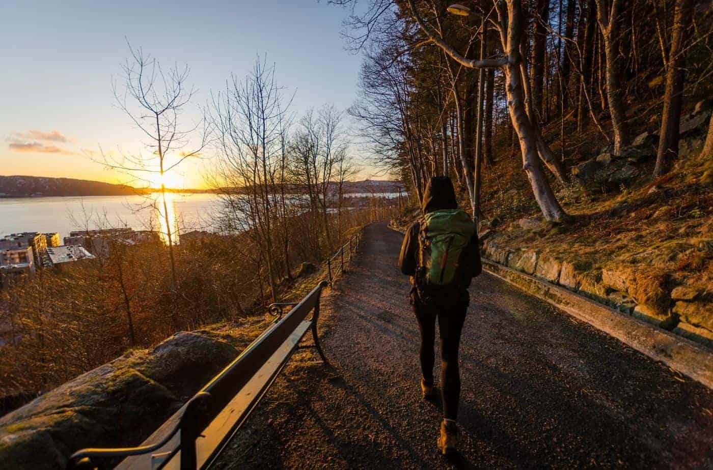
No trip to Bergen is complete without a hike in the mountains – that is what Bergen is famous for! Still, though, hiking may not be for everyone, or you may have limited time for a hike. That’s where the Fjellveien hike comes in. Fjellveien is one of the most famous hiking routes in Bergen and what’s so great about it is that it is flat, making it perfect for all ages and fitness levels. By doing the Fjellveien hike, you get a lovely look at the Bergen mountains, forests, historic buildings, fjord, and cityscape.
For this article, I walked the entire length of Fjellveien hike, making a note of all of the major points of interests along the way. I’ve also written down how to get to/from Fjellveien.
In this article...
Overview of the Fjellveien Hike
Fjellveien (“Mountain Way” in English) is a path that goes along the mountains Sandviksfjellet and Fløyen in central Bergen. The trip starts at Munkebotn in Sandviken and travels through the suburb of Mulen, the city centre, and then into the expensive area of Bellevue and Kalfaret. The walk ends in front of the historic Bellevue Restaurant.
Length and elevation
In total, the length of the Fjellveien hike is 4632 metres (4.6km / 2.8 miles). It is probably the flattest hike in Bergen. The path is mostly a gravel path, though there are some sections where you have to walk on a road.
In total, according to my Apple Watch, there was an elevation difference of 133 metres across the entire length.
Time to allow
Walking the entire length of the Fjellveien hike took me 80 minutes – and that includes stopping a lot for photos and venturing off onto detour paths. You could do it in under an hour if you are in a hurry, or even quicker if you jog the entire length.
You can do the walk in either direction. Sandviken – Bellevue worked for me, but you can start from Bellevue. I’ve included how to get to both starting points in the next section.
Getting to Fjellveien
For my walk, I started Fjellveien on the Sandviken end. You can start on the Kalfaret end, but I found starting at Sandviken a little easier, a prettier direction, and then Kalfaret was easier for me to get back to the city.
Taking the bus
To the Sandviken Start
I took the bus from Bryggen. There are two bus stops (A & B) in front of the wooden houses. These are the buses you can take:
- 3 towards Støbotn
- 4 towards Flaktveit
- 5 towards Åsane Terminal
- 6 towards Lønborglien
- 83 towards Øyjorden
Buses 4, 5 and 6 are the most frequent. Some leave from Bryggen platform A and some leave from Bryggen platform B. All take roughly 7 minutes / 5 stops to Gamle Bergen.
The stop to get off at is GAMLE BERGEN (like the open air museum!)
Once off the bus, head up the stairs and follow the road (Sandviksleitet) to the right. You’ll walk through a health centre (helse). Eventually the path will join with Munkebotn (it can be a little confusing; I used Google Maps to get there). Once at Munkebotn, keep following it (don’t go uphill; follow it to the right) until it splits into Fjellveien and Amalie Skrams vei.
To the Bellevue Start
The best bus that involves the least walking uphill is Bus 11 towards Starefossen. You can take it from Strandgaten (the stop right in front of the swan pharmacy), Småstrandgaten (close to the old city hall), or from Stadsporten (outside the old city gate). You get off at BELLEVUE, which is right at the beginning of Fjellveien.
For the walk below, I start from Sandviken.
Fjellveien Walk
Beginning: Sandviken

The walk starts along a very nice shaded path, where you feel like you’re walking in the woods. If you look between the trees to your right, you’ll see lovely views out to the city fjord.
History of Sandviken
Fjellveien was built in the late 19th/early 20th centuries by the Forest and Tree Planting Company (Bergen Skog og Taeplantningsselskap). Ole Irgens is often considered the ‘father’ of Fjellveien as he had a lot of input into its construction. At the time, Ole Irgesn was the school inspector of Bergen.
Here are the stages (according to our walk)
- Sandviken – Mulen: Built between 1901 and 1906
- Mulen – Beautification: Built between 11879 and 1882
- Beautification – Belleveue: Built between 1890 and 1894
Permisjonsstein: Sandviks Battery Detour
One of the first detour paths you’ll pass is the one that leads up to Sandviks Battery. It’s a little bit hidden as it’s not so much a path but rather an opening in the woods. The path to Sandviks Battery is relatively unknown; restorations have just been completed. (the local newspaper Bergens Tidende did an article about it here). The Sandviks Battery was built as part of Bergen’s inner fortifications in the late 19th century. Germans used it during World War II and built additional bunkers in the area. The name, “Permisjonsstein”, translates to “Permit Path”. When the soldiers were granted permission to leave, they would take this path down to Bergen.
Sandviks Battery closed in 1952.
Sherpas came to restore the path in 2019. They brought in their own equipment and worked to build stone stairs on the path. The path to Sandviks Battery has around 220 steps. It starts out flat, but gets steeper towards the end. If you walk slowly, it’ll take 15 minutes to get the top.
If you want to do a detour to Sandviks Battery & Stoltzekleiven, see this walking overview (external link). Allow another 1.5 hours to complete this. Click here.
You can watch a video of the hike up here.
Old Hydro Plant
The next point of interest is on your left; this abandoned building looks to be a hydro plant. The sign above the door says “BKK”, which refers to the Norwegian power company Bergenshalvøens Kommunale Kraftselskap. They have 29 hydroelectric plants throughout Western Norway. This building is a transformer station from the 1920s. Its connection to a nearby waterfall follows the old Stoltzekleiven route (see below).
Stoltzekleiven
Stoltzekleiven is a well-known and popular hike amongst locals. In total, the hike has 908 stairs to the top. The elevation is 301.44 metres, the length is 834 metres, and the average elevation is 36%. It is quite a narrow path, and hikers are recommended to walk up only; heading back down via other nearby trails.
The original trail was part of the Stoltzegården Farmstead; the name “Stoltz” comes from the German family that settled here. Gerhard Stoltz (1833-1907) was a German merchant who took over the farm Frydenlund (located at Gamle Bergen) and made it his year-long residence, renaming the property. He planted the shrubbery area up the mountain. The trail was laid out in 1900 over the old herding path. The spruce and pine trees we see are from 1870.
Every September is the Stoltzekleiven Opp race. The event runs over two days from 9:15am to 6:15pm and runners go up every 10 seconds. On average, 6,300 people register for the event.
The current record for men is held by Stian Øvergaard Aarvik (a professional mountain runner) with 7 minutes and 46 seconds. For women, it is held by Kristin Størmer Steira (a cross country skiier who has represented Norway at the Winter Olympics) in 9 minutes and 35 seconds. It takes me 30-45 minutes to do the hike.
If you want to detour up Stoltzekleiven, walking down is discouraged. The path is too narrow, and locals only walk up.
You can come back down via Munkebotn (where we started after the bus stop) or Skredderdalen (see further along this walk). You can also walk to Fløyen from the top – this is the easiest but longest walk.
In 2011, Stoltzekleiven was refurbished with the help of Sherpas.
White Manor House
The white house you see here is the Bergen Skipperforenings Skipperhus, or the Bergen Skipper’s Association. The building dates to 1919 and maritime captains from the surrounding area make up the association. A retirement home has also been in here (see marcus.uib.no). In a recent newspaper article, the building has a market value of 43 – 51 million NOK.
In front of it is another large house with a green tower and orange ceramic roof. Dating back to 1885, this building functioned as a retirement home for factory workers. From at least 2014, it is accommodation for students with a total of 37 apartments in the building (see this newspaper article).
Christinegård
Mon Plaisir is a pavilion from the old Christinegård Estate, who owned this property. You can’t see the house from here, but it’s directly below us.
Christinegård is a “pleasure farm” (kind of like a holiday house) that dates back to the late 17th century. Christine Caspersdatter Middeltorp had the property built after her wealthy merchant husband died in 1694 and left her with a large sum of money. Very little is known about this first home.
When Christine died in 1706, her daughter inherited the property. She passed it onto her son, Berent Madzen Chairman, whose wife Modesta Hansdatter Chairman, took over the property in 1747. She had the house rebuilt in 1763 with the main facade facing the fjord. According to the fire regulations of 1766, the property had a farmhouse, covenant dwelling, barge, barn and stables. Modesta’s son, Hans Berentsen Chairman, took over the farm in 1783.
After the death of Hans, Christinegård was sold in 1822 to Dutch Consul general Michael Djurhus Prahl (1781-1851), who had the house completely rebuilt in the 1830s. The new building was two storeys and had the same position as Modesta’s, with the front looking out to the fjord. It was surrounded by a bastion, making the property look like a fortress.
The front of the house has six pillars and a large porch, and there are window shutters on all the windows. This style gives it a very southern feel.
Originally the property extended all the way up the mountain, but when Fjellveien was constructed in this area, it cut right through Christinegård’s property. Most of the land was sold off in the 120s to build apartment buildings.
Christinegård was listed for protection in 1927, and between 1934 and 1958 it was the residence of the bishop. During World War II, Bergen’s commissioner-in-charge held Christinegård, and he held municipal funds in the building. Archaeologist Asbjørn Herteig, known for his work in the Bryggen excavation, took over Christinegård in the late 1950s and his descendants own the property today. It is not open to the public. On Google Maps, the house is now listed as a gallery:
https://www.gallerichristinegaard.no/
Mon Plaisir
Mon Plaisir was built in 1836 for Michael D. Prahl, and ‘mon plaisir’ means ‘my pleasure’. The wooden building is shaped like a small Roman temple. In the photo above, you can see the fortress Sverresborg, built in the late 10th century by Sverre Sigurdsson during the Norwegian civil war. Just behind it is the church on Nordnes, Nykirken. The pink building to the front right is a high school
The City of Rhododendrons
The next little section of path has some lovely rhododendrons, which will be in bloom in May/June.
Once you get past them, be sure to turn back around and you’ll see a sign dedicated to the rhododendrons.
Mulen River & Water Plant
Muleven is a river that flows down the mountainside. Originally, it would’ve gone all the way down to the fjord, but today it flows through pipes from Fjellveien downhill. The name refers to a number of mills that were established on the river to make use of the power of the stream for electricity.
Until 1877, this was the city of Bergen’s northern boundary. This is also the point where Sandvik Mountain (Sandviksfjellet) becomes Fløy Mountain (Fløyfjellet).
In 1876, the mills and water rights were purchased by the municipality, and four of the five mills were demolished, while the one remaining was in operation until 1912. The municipality planned to use Mulelven for both water and electricity. Mulevannverket (Mule Water Plant) was established to provide the local community with water in homes. Mulevannverket had the ability to supply the whole city with water if the main water plant at Svartdiket was to malfunction.
Eventually Mulevannverket was taken out of use. Since 1997, Mulelven has not been a source of drinking water.
It is possible to walk up the path you’ll see in the image to the left of the building. If you walk up there you’ll be able to see Mulelven. I didn’t go too far as I felt the gravel was slippery. You can certainly hear the river, but my photos don’t do the view justice.
Skredderdalen
This is also the beginning point of the hike Skredderdalen. Skredderdalen is a steep hike that is seen as an alternative to Stoltzekleiven if you want to get as high but do something a little easier. As you make your way up, you’ll pass the old damn built for the waterworks. The path will lead you to another path that will take you to Fløyen (See the hiking information here). It can also be a path down if you want to go up Stoltzekleiven. Here’s a link to that path.
Mulen
We are now in the residential area of Mulen, located between Christinegård and Bergen city centre. The name comes from the mill operations that took place along the river. It’s believed there was a farm here in the 1300s and that livestock were kept on the hillside.
Inner City Views
We are now in the city centre of Bergen, where below us will be Bryggen. It’s not visible from the path, though. For a short portion of the walk, you’ll be walking on a road as you cross through the suburb Breistølen. Fjellsiden is a residential area just above Bryggen. It was developed in the 19th century as the city was in desperate need of more housing due to a huge increase in the population. These wooden houses were built in a uniform grid pattern and were apartment buildings. The apartments were tiny; often they’d have one room and may have up to 12 people!
Today Fjellsiden is a very expensive area of town. Some of these houses are now single residence buildings, but many are still tiny apartments.
Hesten Trenger Hvile
The main interjunction that links Fjellveien with Bergen city centre and Fløyen is called hesten trenger hvile, or “horses need rest”. There is a small fountain here as well as a statue of Ole Irgens, the ‘father’ of Fjellveien.
From here, there are two paths you can take. The first is Tippetue, which is a scenic walk up to the top of Mt. Fløyen and the top station of the Fløibanen. The second is a path down to the city centre; ending somewhere near the Fløibanen lower station.
Tippetue
Why the name Tippetue? Well, Tippetue was a town local who lived in Bergen in the last half of the 19th century. He frequented the pub and had outrageous behaviour when he was drunk, so the locals called the area Tippetue. In 1908 the road was finished from Fjellveien to Tippetue, and then a few years later the road was extended up to the top fo Fløyen. (source)
The walk up to Fløyen takes around 45 minutes and, while Tippetue is the steepest path to Fløyen, I’d say it is easily the most scenic.
Regarding the walk back down to the city, this can be a way for you to get back to town when you’re finished with Fjellveien if you don’t want to take public transport.
Skansemyren funicular station
Not too long after the Tippetue junction you’ll cross paths with the Fløibanen. The stop is called Skansemyren, which is named after the residential area. The area is approximately 180 metres above sea level. There are many homes and apartments here.
Skansemyren is best known for its communal sports ground, with different training activities taking place here. It is also home to the Tine relay race, which is held every year. The sports ground opened in 1896 with Ole Irgens at the forefront of operations.
The Fløibanen opened in 1918 as a funicular between Bergen city centre and Fløyen mountain. If you are here on a busy summer day you won’t have to wait long to see the funicular; it runs every few minutes. Be sure to wave!
From here, Fjellveien turns into a car road and remains this way for the rest of the walk. You’ve also got to be a little careful as there’s two roads in the area: Fjellien and Fjellveien – be sure to stick to Fjellveien.
Bergen city centre
The mountains you see (from left to right) are Løvstakken and Damsgårdfjellet. On the far left in the image, you can see the black skyscraper building that is the Bergen Media City. Next to it is the county administration building. Front and centre, towards the bottom of the frame, is the Bergen train station (look for the granite building). To the right is the Lille Lungegård Lake (you can learn more about the lake with my Årstad walking tour) and behind that are the KODE art galleries. To the right you can see the tower of St. John’s Church.
If you walk along Fjellveien a little further, you’ll get more excellent views down to the city.
Mt. Ulriken
This is why I think doing the walk from Sandviken – Bellevue is nicest; you get this amazing reveal of Bergen’s largest of the seven mountains, Mt. Ulriken. Mount Ulriken is 633 metres high and is characterised by its TV tower on top. There is a cable car that will take you to the top of Mt. Ulriken, and it’s also a popular (but difficult) hike.
Forskjønnelsen (Beautification)
Beautification is a scenic zig-zag road and park that leads from Kalfaret up to Fjellveien. It was designed as a park in 1799 and has some lovely old villas close by (see my Årstad Walking Tour where I cover this in depth). It was formerly known as Lassens Minde (Lassens Memorial) after the parks designer, Customs Inspector HM Lassen, who also had the bushes and trees planted.
This is a way back to the city if you wish to use it rather than take a bus back. If you head to the bottom you’ll end up on Kalfvarveien; turn right and you’ll see Stadsporten (The City Toll Gate). A couple minutes walk from there is the Bergen Train Station.
Kalfaret
Kalfaret is a suburb just outside the city centre of Bergen and was ‘the country’ (i.e. not part of Bergen) until 1877. The name comes from Calvarieveien (Calvary Road) and refers to the old Catholic tradition of walking around a road that is 1200 steps in length on Good Friday. This is approximately the distance from St. Jacobs Churchyard (next to Stadsporten) up to Kalfartoppen, the highest point in Kalfaret (this is the first portion of the walk we’ll take).
Starting in the 18th century, a number of country houses were built along Kalfarveien. At the end of the 18th century, a row of Linden Trees were planted along the road, and gradually it was turned into a promenade that became a popular day trip walk with a number of restaurants and cafes along the way.
In the 19th century, wealthy citizens began to move out of the city centre due to overcrowding and had lovely villas built along the mountainside in Kalfaret. Since then, Kalfaret has been synonymous with ‘wealthy Bergen’.
Today a lot of the country houses are gone or have been significantly converted, and the large gardens have been filled with modern apartments. Still, we will be able to see some of the old villas from the late 19th century, and there’s also great examples of the Bergen-style houses.
Bellevue Restaurant
Lyststedet Bellevue has been a restaurant since 1976, when a gazebo was built here. A prospectus from 1801 shows a midmarket house on the site. It was rebuilt in 1899 as a restaurant, and has been a restaurant ever since. It is typically used for weddings and other celebrations. In earlier times, salutes were fired upon guests’ arrival.
Today Lyststedet Bellevue is run by Bellevue Restaurant AS, which also runs Fløien Folkerestaurant and Bryggen Tracteursted.
The business went bankrupt in 2016 and was transferred to another company. As of 2020, their website isn’t live (see here) and the Bellevue Restaurant AS company doesn’t list it on their website.
Bellevue Restaurant marks the end of our walk!
How to get back to the city
Walking
If you want to walk back to the city, you can follow the Fjellveien hike back to Beautification (if you want to be closer to the train station) or the Tippetue junction (if you want to be closer to Bryggen). You can also take Endregårdsbakken (just after Beautification) to get to the city centre. It will turn into Brattlien and that road will end just above Korskirken.
Take the bus
- Walk down Bellevuebakken (it’s to the right of the restaurant if you’re looking at it from Fjellveien).
- When you reach Gamle Kalvedalsveien, turn left.
- On your right will be a path down to the main road, Kalvedalsveien. When you get to the bottom, turn right. Shortly on your side of the road will be a bus stop.
- Take Bus 3 to Støbotn for 8 minutes (6 stops) and you’ll be at Bryggen.
I hope you enjoyed this walk! As you can probably tell by the amount of photos I took, I loved it. I think it’s a great option for anyone in Bergen who wants to see a lot in a short amount of time. You get a perfect blend of nature and cityscapes, and the walk itself is pleasant.
Enjoy Fjellveien!