
Hananipa Hike
If you’re in Bergen looking for a hike that is close enough you can do it in less than a day but also far enough that you can’t hear the hustle and bustle of the big city, then Hananipa is for you!
Hananipa is not one of the famous Bergen hikes. In fact, I didn’t even know about it until one of my friends invited me to join her on the hike. As it had been months since I had left Bergen city centre (thanks, corona), I took the opportunity to go out and see some mountains and a fjord.
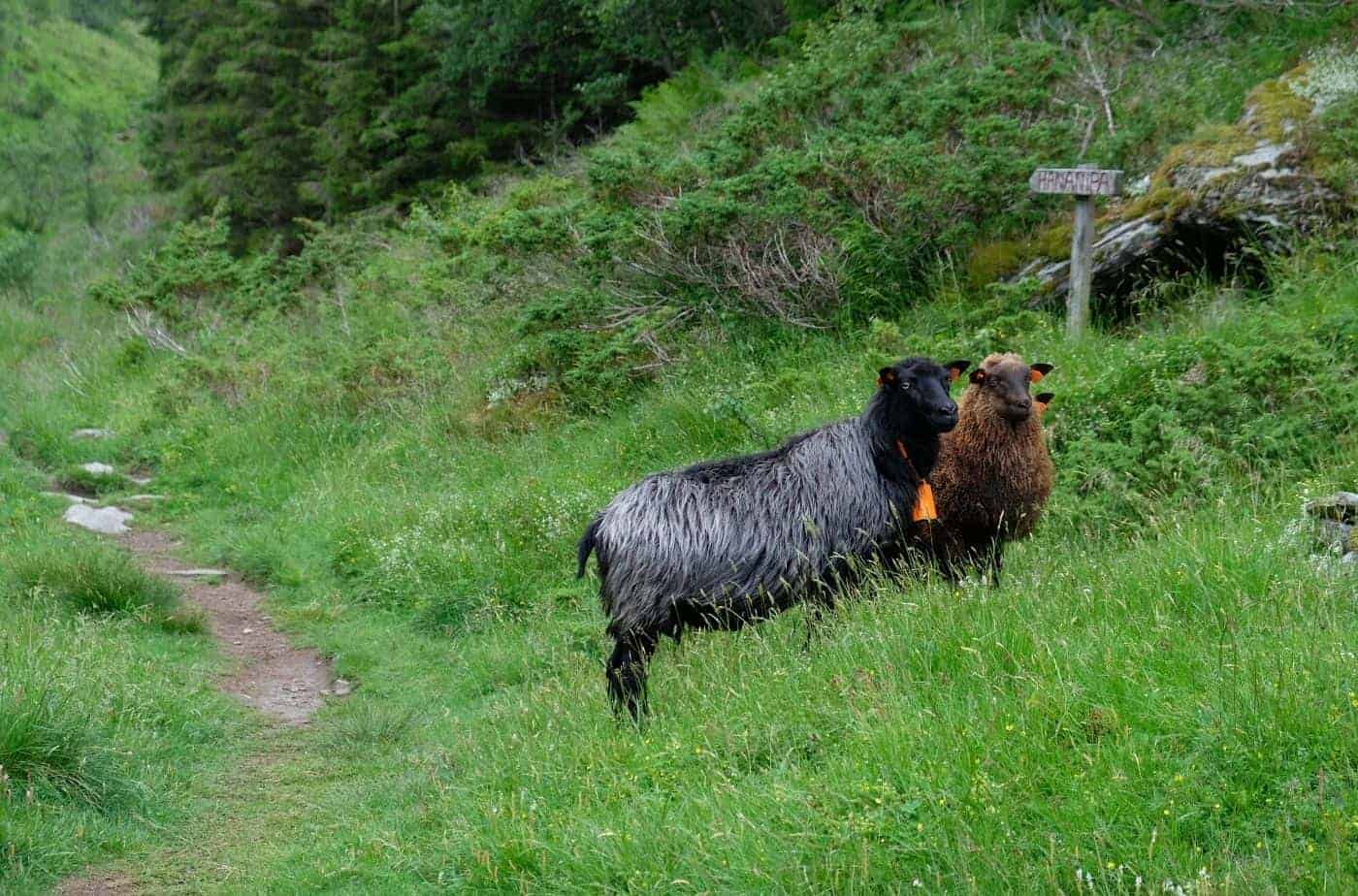
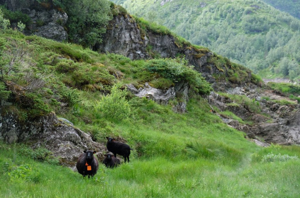
The hike to Hananipa is gorgeous. You see the Sørfjorden, you see farms, fish farms, an old prison, small villages, sheep, and even snow in July! It’s a great taste of West Norwegian nature without having to venture far out into the wilderness.
For this guide, I have tried to focus on including all the information I want to see when I’m planning a hike. Here we go!
In this article...
Is this hike for me?
- Total length (beginning and ending at the train station): 13.8km (8.5 miles)
- Types of path: First 4km (2.4 miles) is a road; last 2.5km (1.5 miles) is a rocky path
- Steepness: First 4km (2.4 miles) is a noticeable but not steep incline; last 2.5km (1.5 miles) is a mixture – mostly it’s slightly steep (almost like walking upstairs) but it does flatten out towards the end
- Safety: This path is safe – you never go close to the edge
- Easy to follow? There are signs at the major turning points, but otherwise the path is unmarked. Still, though, you can see it clearly on the ground.
- Populated? You will likely see other people along the way, but not many
- Facilities: No toilets, shops or cabins along the way (including the train station)
About the mountain
Hananipa is a mountain peak located roughly between the villages of Trengereid and Vaksdal. The mountain is 718 metres (2355 ft) high, above the trees, and offers a panoramic view to the nearby island of Osterøy, the Sørfjorden, and the village of Vaksdal.
About the area
Trengereid is a small village about 18km east of Bergen centre. Trengereid has long been a farming community, well before industry came to the area. It was originally built up as an industrial village thanks to Johan Jebsen, who in 1895 founded Trengereid Fabrikker AS. Using electrical power from its own power plant on Manndalselva, the factory made various textile products. Operation ceased in 1987 and the power plant has since been taken over by BKK, the national power service.
In 1920, the mountains around Trengereid began to be used for mining activities with the Risnes Limestone Quarry starting operations here. The mines provided jobs for 70 men, and the workers barracks were eventually placed with housing. The mines closed down in 1986 and since then no new business has been started in Trengereid.
The population hasn’t decreased from this lack of industry, however, with the locals about to easily commute to Bergen city centre.
Today Trengereid is a traffic hub with road and train connections to Bergen, the Hardangerfjord (Norheimsund), Voss and eventually Oslo. There is a primary school (opened 1896), a parish hall and chapel, and a daycare. Trengereid has a mixed choir with 30 members, and a music club. There are no shops or kiosks in Trengereid; the closest is in Arna.
How to get there
Take the train from Bergen Central Station to Trengereid. You can take the lines to Oslo, Myrdal or Voss, meaning that the train runs fairly regularly.
The train journey takes 17 minutes. You do not need to request the train stop there; it always does.
How do I buy tickets?
Vy App – download the app called ‘Vy’; it’s in English so it’s easy to navigate. Select Bergen – Trengereid and your desired time.
Cost: Around 66 NOK (varies depending on availability)
At the Train Station – head to one of the ‘En Tur’ ticket machines and follow the prompts to buy a ticket.
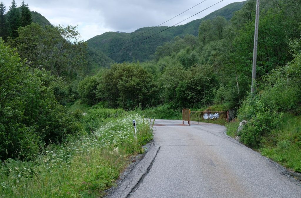
If driving, put “Skulstadvegen” into your GPS and follow the road up the hill. You’ll eventually come to a parking area on your right.
Starting Point
If you are taking the train, you will be starting from the train station – where I started too! The train station is around 3.7km from where the carpark is, and it’s all with a slight up hill (you will walk up 362 metres and it will take around 1 hour 20 minutes to get up there).
If you are driving, you start from the carpark near the lake.
Since most visitors to Bergen will be taking the train, I will begin the walk from the train station. Drivers, skip to the part with the car park!
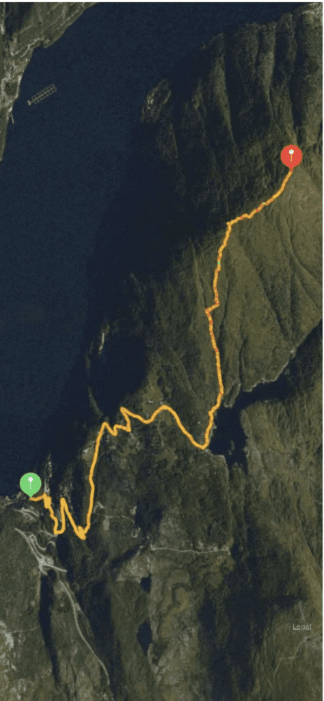
Part One: Train Station to the Lake
Once off the train, cross the tracks. Directly in front of you, you’ll see a narrow staircase through the trees. The path is 150m long.
You reach Vaksdalsvegen, a main road, and turn right. Then turn left onto Trengereidgeila. Follow the path as it curves to the right. You’ll then see a very narrow gravel path on your left – take that to get up to Skulstadvegen. If this road is too steep for you, keep following Trengereidgeila until you get to the main road Trengereidsvingane, turn left, and then take the next left onto Skulstadvegen. If this sounds confusing, Google Maps will take you on the exact same path.
You will now walk all the way up Skulstadvegen – all 2.9km (1.8 miles) of it. The road isn’t steep, but you can feel the incline as you go up.
Don’t be put off by this extra walk – Skulstadvegen is gorgeous, scenic, and a lovely walk. I got to eat some wild strawberries and look at the growing blueberries along the way. There are also many nice houses to look at. Here are some of my photos from the walk on the road:
Eventually you’ll reach some farms with chickens and sheep (if you come in the middle of summer, the sheep will be up in the mountains). You will be walking on private property – that’s totally fine! – but you do pass through two gates that you can open but have to close.
Eventually you reach Skulstadvatnet.
Part Two
When you reach Skulstadvatnet (the Skulstad Lake), you’ll see a sign about the local hiking trails. We are following signs to ‘Hananipa’. You can’t miss this point; the dam is right in front of you.
Turn to the left and continue to follow the path along the left-hand side of the lake. This is where it will start to get rocky and narrow, but it’s never too steep.
Eventually you’ll reach the other side of the lake, which is a nice rest stop before starting the next part. There’s a small stream there if you want to fill water bottles. There is also another sign pointing to Hananipa.
Now comes the steepest part of the walk – you’ll be basically walking along the stream as you head up this wooded valley. The path is very narrow and it’s made up of rocks. Luckily it’s short – only a few hundred metres – so you can rest at the top where the trees end.
Now for the last part of the walk:
Part Three
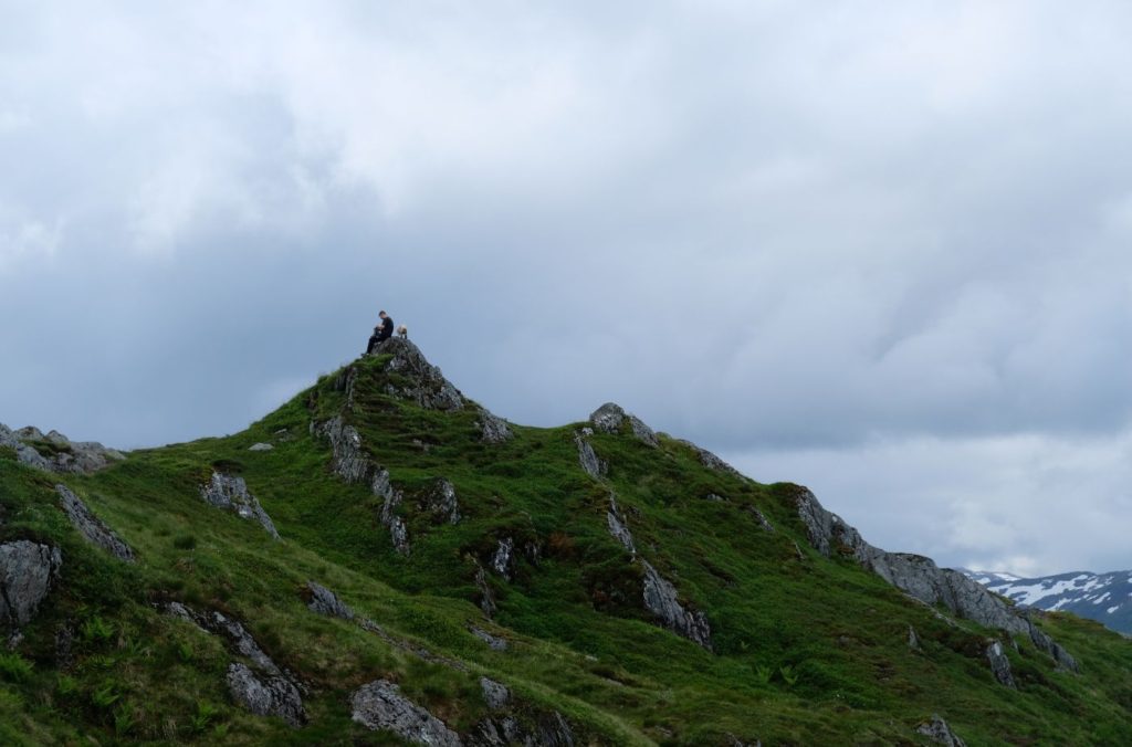
It takes around 30 minutes to get from the top of the valley to the mountain peak, so you really are on the home stretch. You’ll also be around 500 metres high at this point, so you’ve done most of the climbing! The trees are gone, and there are amazing views down to the Sørfjorden on your left-hand side. You’ll also the peak straight in front of you. It’s very grassy at the top, so the path is always pretty clear.
You will soon pass a small cabin on your lefthand side. I’m not sure if this is a public or private cabin; when we went, we saw some tents next to it.
The last little bit before the peak is a little steep, but it’s short-lived and you can see how close you are!
When we went, there were plenty of sheep up there staring us down!
What you see from the top
If you walk a little bit past the peak you’ve been walking towards, you’ll see the stone marker indicating the top of the mountain. It’s from this point that you get incredible views out to Vaksdal and Osterøy.
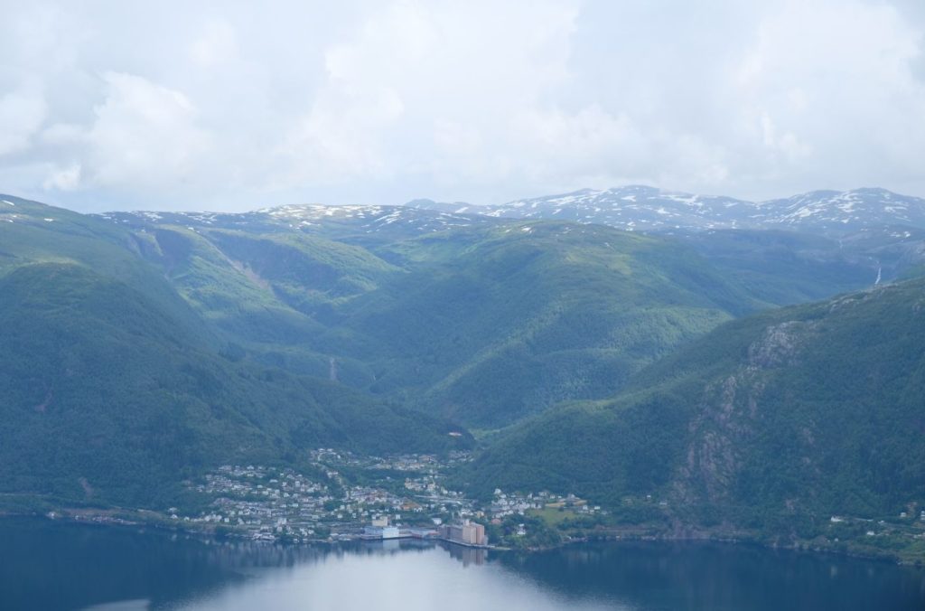
Vaksdal
Vaksdal is a municipality in Western Norway with a population of around 3,977 people. During World War II, there was heavy fighting in the municipality as the German forces advanced along the railway line from Bergen towards Voss. The heaviest fighting took place in Vaksdal between 19 and 23 April. Three Norwegians and one civilian, as well as a larger, but unknown, number of German soldiers fell in the village.
You can see the Vaksdal Mill from Hannaipa. When the mill was established in the early 1900s, it was the largest in Scandinavia. It produces grain and flour. It is an industrial municipality with 20% of the work in industry and 32% in construction, power and water supply. 26% of workers in the village commute to Bergen for work.
If you are up there on a clear day (about as clear as I had it), you can see the Folgefonna Glacier and the mountains along the Hardangerfjord (you can’t see the fjord). In my photos, these are the mountains that still have snow on them. The glacier is fairly easy to spot as it’s a flat, white strip in between mountains.
The Prison
The island is called Ulvsnesøy and it has a lot of history for such a small island. It was probably first used as a monastic property, and later it became church property.
In 1881, a boarding school for ‘bad’ boys aged 10 to 15 was established on the island. The institution was founded by Ole Irgens, Bergen’s school inspector at the time and ‘father’ of the Fjellveien trail in Bergen city centre. In 1900, the school was known as “Ulvnaes Lake School Home for Neglected Boys” and in 1951 it was changed to “Ulvsnesøy School for Boys with Disabilities”. The boys who lived there were sent by the authorities due to neglect of behavioural problems. In total, about 30 boys were there. The school closed in 1981.
From 1982 Bergen used the island as a prison. At most, it had 31 inmates, 9 of which were women. The inmates were employed on the island, maintaining the buildings and farming. Farmers on the mainland could also use the prisoners as extra labour. The prison closed in 2019, was put up for sale, and the island sold for NOK 11.8 million. Whoever bought it has to use the island for business purposes, according to law.
Going Back Down
We took almost the same amount of time going back down, and that’s mostly because there are some rather large steps down that slows you a little bit.
You do get some nice views going the other way, including the cabin we passed earlier.
If the path feels confusing, you do see the lake in front of you all the way down, so it’s easy to navigate.
The walk down the road back to the station was the toughest bit for me; it’s around that point that I started to feel tired. We checked the schedule for the train when we got back down to the lake – it took a little over an hour to get from the lake to the train station once we knew when the train was coming.
Make sure you keep an eye out for Gullfjellet, the largest mountain on the Bergen peninsula.
It has a flat, rocky top and is covered with snow practically all year round. In the photo, it’s the peak in the middle of the frame.
When you reach Trengereid Train Station, head to the picnic benches and take a well-deserved rest! When we were there, and possibly very often, the station building is locked, so you will have to wait outside.
Have you done Hananipa hike? Let me know in the comments!