Emma

Hey! My name is Emma. I'm from Australia but have lived in Bergen, Norway, for the last eight years. I work as a local guide and tour leader for all over Northern Europe. The Hidden North is an online travel guide I have made to help you plan your own visit here.

  • Why You Should Absolutely Visit the Viking Ship Museum in Oslo

    Important: The Viking Ship Museum is closed for renovations until 2027

    The Viking Ship Museum in Oslo

    No trip to Norway is complete without seeing something to do with Vikings. Luckily, it is the Viking Ship Museum in Oslo can provide the Viking fix you need. Focusing on three Viking ships and their burial sites, the museum provides an incredible insight into the life of the Vikings, which is much more unique than many other museums which focus on their trading history. Instead, this museum focuses on what they found important to them, how they respected the dead, and how they viewed the after-life. Probably the most popular museum in the country, it’s hard to pass up a chance to see real Viking ships in person.

    In this article...

    About the Museum

    The museum focuses around three Viking ships that were uncovered in areas around the Oslofjord from the late 19th to early 20th centuries. The ships, titled Tønsberg, Oseberg and Gokstad (after where they were found), are the best-preserved Viking ships in the world.

    Besides the ships, there’s also an excellent exhibition with the items that were found in the Viking ships. They are placed together to provide an incredible insight into how people were buried and what each item meant in the afterlife. There are also two graves – a man and a woman – that were uncovered with the ships.

    Important: Renovations at the Viking Ship Museum

    From autumn 2021, the Viking Ship Museum will close for five (!) years for a major renovation. Why? The current building and huge increase in traffic is causing the ships to decay at a fast rate. A new building will house the ships and protect them much better.  They have a whole website with information about the new museum, but it’s all in Norwegian. Here are some highlights:

    • The new museum will be completed in 2025 (I think this will be delayed. 2024 confirmation: Yes, this was delayed!)
    • The new building will be climate regulated
    • The new museum will be three times as large as the old one
    • This will be an extension to the current building

    The Three Ships

    The Oseberg Ship

    The Oseberg Ship is 96% original. It was excavated in 1904-1905 in what is considered the world’s largest burial site. Parts of the ship date back to 800 AD, but recent research indicates that the ship may be much older. This ship is the most popular for a reason; it so clearly evokes the power and strength of the Vikings and their seafaring capabilities. Spend some time admiring this beauty.

    The Gokstad Ship

    The second of the three ships you will see is the Gokstad Ship. This is the largest of the three ships and was uncovered in 1880. Inside this grave, they found a skeleton of a man in his 40s-50s with a powerful build. Some items were also found here, including small boats, a tent and riding equipment. While looking less like a Viking ship and more like a regular boat, it’s still impressive to see.

    Be sure to walk past it to the end of the room, where you’ll see the two skeletons that were uncovered with the ships. The man mentioned above as well as a 25-30 year-old woman.

    The Tune Ship

    Opposite the Gokstad ship is the third ship – Tune. This is the least complete of all the ships but was the first excavated in 1867.

    Behind the ship is one of the burial tends that was uncovered during the excavations. This is interesting to look at; especially how elaborate these graves were. Here you’ll see the smaller boats that were excavated along with the large ships.

    What You Can See in the Museum

    Watch the short film

    A newer addition to the museum, there is a short film that plays on the ceiling above Tune three times an hour. The film, which has music but no words, provides an overview of the life of a Viking and Viking ship, from the time the ship is built to the time the Viking dies in battle and is buried. It’s an okay film and worth stopping for if you are there when it starts.

    Explore the additional exhibition

    The last corner of the museum is the exhibition, where various textiles, chests, jewellery pieces, and statues from the burial sites have been put on display. Information boards in Norwegian, English and German provide useful information into what the object is, as well as why it was buried with the individual. This part of the museum is where you’ll spend most of your time. See some images below – the best room in this exhibition is the textile room, but sadly images aren’t allowed there. Also, the glass cabinets make photo-taking a little tricky. But, of course, it’s much better in person 🙂

    Facilities & Practical Information

    Shop

    I love a good souvenir shop, and this one certainly delivers. Think of it as ‘Viking overload’ if you can put a Viking on it, it’s for sale. There’s even a Donald Duck cartoon about the Oseberg ship. The book selection is the best in the country – most of the books are in English and cover everything (and I mean everything) about the Viking Age. I have bought a book on the Vikings in Norway, Norse Mythology, Snorre Sturluson’s Sagas, and one about a Queen called Emma (it felt fitting). There are t-shirts, posters, Viking helmets, keychains, magnets, figurines, statues, and so on. Prices are typical of Norwegian museums.

    Museum Guidebook

    If you are looking for a museum guide, the shop sells a book called The Viking Ships in Oslo. It uses some of the information from the signs around the museum, but also builds on the discovery and excavation of the ships, the design and build, the symbolic details, and how the ships are being preserved. It’s more novel than museum guide and not something you will read while in the museum, but it does provide an excellent insight into the ships, Honestly, after reading the book, I just wanted to go back and take another look at the ships – not something everyone will be able to do.

    The book costs 69 NOK

    Museum Brochure

    The museum has a brochure that it shares with the Historical Museum, and it mostly provides an overview of the exhibitions in each museum. The information about the ships is the same as the information boards.

    Languages

    The museum has information boards in English, German & Norwegian. The brochure is available in more languages.

    Notes

    Crowds in Summer

    The Viking Ship Museum is the most popular in Oslo, and when you go (especially during summer) there will be other people there. Almost every cruise ship offers excursions there, and almost every tour group goes there. It gets crazy packed.

    If you want to avoid crowds, either visit out of season (Oct-April) or go in the evenings. Most tour groups & cruise ships do their tours between 8:30am and 12pm or maybe in the afternoon around 1pm-2pm. In summer the museum closes at 6pm.

    Tickets & Security

    As soon as you enter the building, the ticket office is immediately to your right (there may be long queues blocking the door). You scan your Oslo Pass, or pay for your ticket, at the ticket office.

    Afterwards, there is a ticket inspector before you are able to enter the museum. This is not museum staff; rather, it is a security guard.

    Bags are not allowed inside the museum. The security guard will be checking this, and you will have to leave your bag outside in a locker if he catches you. Be on the safe side and put your bag inside the locker before queuing to enter the museum.

    When you buy your ticket it gives you free admission to the Historical Museum, provided you use it within 48 hours.

    Practical Information

    Opening Hours

    • 1 October – 30 April: 10am – 4pm
    • 1 May – 30 September: 9am – 6pm

    Prices

    • Adult 100 NOK
    • Students/Seniors 80 NOK
    • Children under 18: Free
    • Oslo Pass: Free
    • Note – your ticket gives you free admission to the Historic Museum if you visit within 48 hours of the Viking Ship Museum

    Getting Here

    • Take bus number 30 towards Bygdøy (stop: Vikingskipene)
    • Take the Bygdøy ferry (summer months only)
  • The History of Oslo

    The History of Oslo

    The history of Oslo is truly fascinating. While today the city is very modern and there may seem like there are few traces of its beginnings, there are hints of history everywhere.

    Here’s my summarised history of Oslo!

    In this article...

    Humble Beginnings

    Oslo is one of the oldest places in Norway; the area around the Oslofjord has been inhabited since the last ice age due to its rich agricultural land. The oldest settlements date back to the Stone Age and the Bronze Age. Historically the area was called Viken, which means ‘the bay’.

    It’s believed that the Oslofjord was an important place for the Vikings; this is mostly because three Viking ships have been found in the area. These are now on display at the Viking Ship Museum. The first church, St. Clements Church (Klemenskirken), was built in Oslo around the year 1000. Sadly the church is no more; its ruins can be seen in the Middelalderparken just outside the city centre.

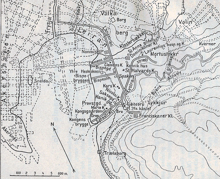
    File:Medieval Oslo map.jpg


    Medieval Oslo. Akershus is on the bottom left. The hilly area to the right is Ekeberg.

    Oslo wasn’t officially founded until 1049. It was founded by King Harald Hardråde (Harald Hardruler), but it was his son, Olav Kyrre (Olav the Peaceful, who also founded Bergen), who set up a cathedral and a bishopric. Oslo wasn’t where it is today; rather it was founded closer to the region around Ekeberg and where the Barcode is today (the region called Gamle Oslo (Old Oslo) highlights this).


    Mariakirken Oslo

    Throughout the 12th century, cathedrals and a cathedral school were built around the city. This includes Mariakirken, which would’ve looked similar to the church in Bergen. Sadly, like St. Clements, only its ruins remain.

    At the time it was Trondheim that was the capital of Norway. In 1219, the capital moved to Bergen. It wasn’t until 1299 that Oslo got its title as the Capital of Norway.

    The Capital of Norway

    In 1299, King Håkon V decided to move from Bergen to Oslo, and with that, the capital moved. He cemented the city’s status as the capital when he had the Akershus Fortress built in 1299.

    Everything changed in 1350 when the Black Plague came to Oslo. Around half of the town’s population passed away, and the churches began to lose income. This is around the time that the Hanseatic merchants came in to take over trade, and the churches fell into ruins.

    The entire country had lost a lot during the Plague, and because of that, it was forced into a Danish union.

    Danish Union, Fires, and Kristiania

    The Kalmar Union put the three Scandinavian countries together in 1380, and during this time trade in Oslo was dominated by Hanseatic merchants and the town had little going on.

    In 1536, the Danish and Norwegian union became a formal coalition, and the capital proper was now Copenhagen – though Oslo remained a symbolic capital. Due to the Reformation, in which Norway converted from Catholic to Lutheran, many of the old churches (most of which were already deteriorated) were destroyed by the Danes to make way for Lutheran churches. There are many ruins of churches in Gamle Oslo (the old town) today.

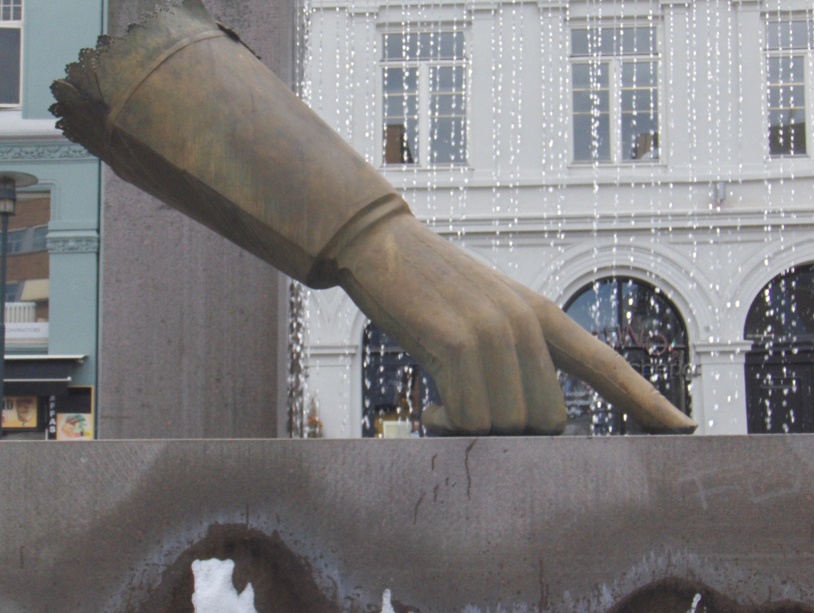
    In 1624, the city changed forever. A massive fire burned for three days, destroying most of the city as it was built in timber. After the fire, King Christian IV of Denmark decided that, rather than rebuilt the old city, he was going to move it and build a whole new city and name it after himself. So, he did. And so Kristiania was born. At the time, it was spelt Christiania, but from 1877 it was spelt Kristiania.

    Image result for oslo 1624
    A statue of Christian IV pointing to where he wants Christiania

    Inspired by contemporary city planning, Kristiania was laid out in a grid close to Akershus Castle. The architecture of the time was Renaissance, and there are glimpses of this style still visible in the old centre of Kristiania. Akershus Fortress was also modernised and converted into a renaissance castle by Christian IV. All citizens and shops were strongly encouraged to move their businesses and homes to the new city, and they did. Around this time, the lower classes started to settle a little out of the city, near Vaterland and Grønland near the Old Oslo area.

    Image result for gamle rådhus oslo
    Oslo’s first town hall from 1641

    The area of Oslo today called Kvadraturen (the quadrature) is where King Christian IV moved the town. The oldest buildings in Oslo can be found here, including Kristiania’s first town hall and the oldest restaurant, Cafe Engebret.

    It wasn’t until the 18th century that Kristiania started to see true growth when the (constant) wars between Denmark and Sweden boosted the town as a major shipbuilding and trading port.

    File:Christiania Norway in 1814 by MK Tholstrup.jpg
    Christiania in 1814. The fortress is visible out on the peninsula.

    Christiania Self-Guided Walk

    I’ve written a self-guided walk for Christiania so you can explore the old town independently. 

    19th Century Capital & Growth

    In 1814, when Norway left the Danish union and was forced into a personal union with Sweden, Kristiania was re-instated as the capital. The 19th century was a period of massive growth for Kristiania; with its status back, several state institutions were established including the Bank of Norway (1828), the Royal Palace (1848) and the Storting (1866). In 1859, many of the surrounding areas were incorporated into Kristiania – including Old Oslo, which at the time was just called Oslo.

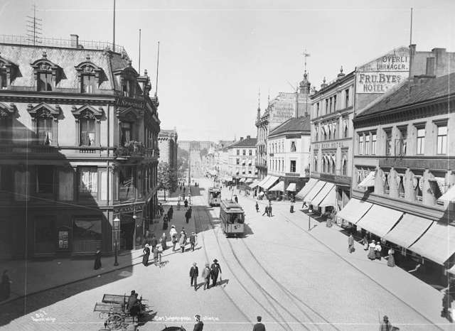
    Karl Johans Gate 1890

    The population increased dramatically in the 19th century – from 10,000 in 1814 to 230,000 in 1900. Finally, Kristiania overtook Bergen in terms of population. There was a spectacular building boom during the end of the 19th century, and many new apartments were built around the city centre.

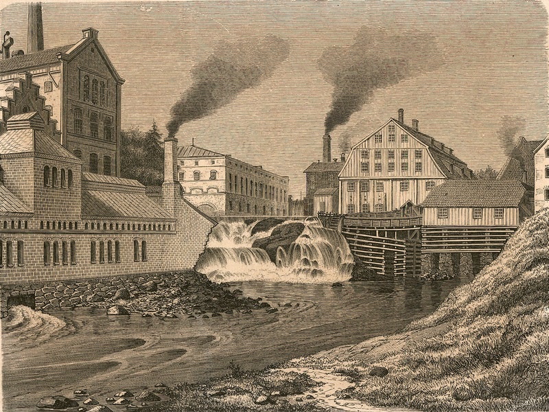
    File:Hjula Veveri JWC.240.jpg
    Akerselva 19th century

    Industry also rose dramatically in the 19th century, especially along the Aker River (Akerselva). Various industries were here, but they were primarily timber and fabrics. This is due to the number of waterfalls on the river, which gave power to numerous industry companies in Oslo.

    File:Stortorvet 7, Stortorvet 8 med Kaffistova, Karl Johans gate 15, 1926, Anders Beer Wilse, Oslo Museum, OB.Y2962.jpg
    Downtown Oslo (Stortorvet) in 1926

    Oslo Returns

    The city and municipality used the name Kristiania until 1 January 1925, when the name was changed back to Oslo. The reason the name was changed is because, after Norway became completely independent in 1905, the locals thought it was inappropriate to have the capital named after a Danish king.

    World War II

    During the Second World War, Oslo (like the rest of Norway) was occupied by German forces. Oslo was one of the first cities in Norway to be occupied; on 9 April 1940 the German ships made their way down the Oslofjord, and while the fortress Oscarsborg was able to sink a major warship and delay the occupation long enough for the King and government to escape, the city was occupied later that day.

    Image result for stortinget oslo nazi
    Parliament with a German sign & Nazi flag flying

    During the war, the main headquarters for the Germans was Victoria Terrasse, a beautiful building close to the Royal Palace. It was in this building that officers held the interrogation centre for all prisoners in Oslo, and the place became synonymous with torture and abuse. On occasion, prisoners jumped out of windows to their death while waiting to be interrogated. Allied bombers tried to destroy it twice, but missed and hit civilian targets.

    Image result for oslo wwii
    Karl Johans Gate

    All ships carrying Jews left for mainland Europe from the Oslofjord, and the German Army executed members of the Norwegian resistance groups at Akershus Fortress. After the war, eight Norwegian traitors who had been tried for war crimes were executed at the fortress, including Vidkun Quisling.

    Modern Oslo

    Oslo 1971

    After the war, Oslo’s City Hall was finished in an area that had previously been a slum. This was also where Aker Brygge was revitalised between 1982 and 1998 and built up as a modern suburb.

    Oslo’s postwar absorption of surrounding towns and suburbs gives us the sprawling city we see today. However, despite this growth, it wasn’t until the discovery of the Ekofisk oil field on Norway’s Continental shelf, that the economy of Oslo changed for good. Oslo transformed into one of the world’s wealthiest and liveable cities.

    Oslo is the most ethnically diverse city in Norway, with 40% of the population first or second-generation immigrant.

    Image result for oslo wwii
    Terrorist attack 2011

    In 2011, Oslo was hit by a terrorist attack carried out by a right-wing extremist. A bomb was detonated in the Government quarter, damaging several buildings including the building that houses the Office of the Prime Minister. Eight people were killed in the attack. The terrorist then disguised as a police officer and killed 69 Labour party-affiliated activists on the island Utøya, about 45 minutes out of the city.

    Oslo City Centre Self-Guided Walk

    I’ve written a self-guided walk for Oslo so you can explore the major highlights of the city. 

  • How to Experience Dalsnibba Viewpoint in Geiranger

    Visiting Dalsnibba Viewpoint

    Geiranger is undeniably becoming one of the most popular places in Norway to see a fjord. The Geirangerfjord is UNESCO World Heritage-listed as it perfectly represents how a fjord is carved out from melting ice. In other words, the Geirangerfjord is the fjordiest of the fjords. And there is no better place to see the Geirangerfjord than from Dalsnibba Viewpoint.

    Termed ‘Europe’s highest fjord view from a road’, Dalsnibba viewpoint gives you an incredible view over the village of Geiranger and the Geirangerfjord. Located 1500m (4921 feet) above sea level, it’s a truly spectacular sight. It is somewhere I take private groups, and while I definitely think it’s worth making the trip to the top, there are some things you need to keep in mind.

    Table of Contents

    The History of the Dalsnibba Viewpoint

    Regarded as one of the most ambitious road-building projects ever seen in Norway, it’s unsurprising that it took almost one hundred years before the road went from idea to reality. The plan to build a road was first mentioned in the mid-19th century, however back then Geiranger was a tiny farming village. It wasn’t until cruise ships started to arrive at the beginning of the 20th century, and a little later the addition of motorised vehicles, that the road was put into action.

    Construction for the road began in June 1937 and around fifty men were working on the road. It took two years to build and had an unofficial opening in 1939. It was unofficial due to the outbreak of the Second World War, in which Norway was occupied and tourism became non-existent.

    It wasn’t until 18 July 1948 that the road was officially opened, and it tied in with the visit of the first tourist ship to visit the Geirangerfjord since the end of the war.

    Since its opening, the road has become increasingly popular, and due to a steep rise in tourism, the road has been asphalted and widened to two lanes to allow for tourist buses to go up. 

    What You See at Dalsnibba Viewpoint

    The view is undeniably incredible. For me, I like how clearly it shows how the landscape has been carved out by glaciers. The uneven mountains and rocks in strange places highlight this, and the valley down into the fjord is steep. You also see the village of Geiranger and the Geirangerfjord.

    You can also see a glacier – it’s very small and not one of Norway’s famous ones, but it’s still great to see!

    Visiting Dalsnibba Viewpoint

    Travelling with a Car

    The drive from Geiranger to the viewpoint takes around thirty minutes, but note the road is very narrow and windy – be extra careful when making the trip. Follow the Fv63 out of Geiranger (past the Union hotel) and then turn off to the viewpoint. You’ll see the toll station right away.

    Note – on Google Maps the viewpoint is called “Geiranger Skysslag AS”, which is the name of the transport company who own Dalsnibba.

    The fee to enter is 330 NOK per car. You can buy a ticket online in advance, and the toll booth takes card or cash.

    Note! This price is continuously going up. When I wrote this article in 2021, the cost was 170 NOK for a car. Now it’s 330 NOK! I recommend checking their website directly for the most current price. Click here

    The short drive from the toll booth to the viewpoint consists of hairpin turns, and if you come across a tour bus it can be very tricky. Be careful and follow the bus drivers signals – if he tells you to drive past, drive past. If he tells you to wait, wait.

    Parking is ample at the top, and you park right in front of the viewpoint.

    You go back down the same way you came.

    Road-trip Guide

    You can get my road-trip guide for the Fv63 via the link below. 

    Travelling without a Car

    Several tour buses operate from Geiranger, and this may be a good option if you don’t want to risk your car, or perhaps you just want to sit back and admire the view.

    This bus operates purely to drive people between Geiranger and Dalsnibba, and it operates whenever there is a cruise ship in town. The total trip takes 2 hours and 15 minutes, and you spend 15 minutes at the viewpoint. They also stop at Flydalsjuvet, a photo stop closer to the village. The bus has recorded English commentary.

    Click here to view their website

    The public buses in Geiranger also drive up to the viewpoint. The local bus operates three times a day and stops at Dalsnibba for 20 minutes.

    Doing it on Your Own

    If you don’t want to do it with groups, you can hire someone to take you up there:

    • Take a limousine: Geiranger Fjordservice offers private cars to drive you to the top. They have two different paths to Dalsnibba – either Trollstigen or the old Stryn road. Prices start at 5,300 NOK (Link)
    • Take a Tesla: Geiranger Fjordservice also offers a sightseeing tour in a Tesla. Prices start at 3,600 NOK (Link)
    • Take a taxi: Geiranger Taxi also offers the trip to the top. Like Geiranger Fjordservice, it offers different tours. Prices aren’t listed on the website, but their tours look great. (Link)
    • Take an electric car: It is possible to rent a tiny electric car and drive yourself (or hire a driver) to go to the top. These look like fun! You’ll see them all around Geiranger. Prices start at 1850 NOK (Link)
    • Take an electric bike: If you are wanting a little more, it is also possible to rent an electric bike. Prices start at 230 NOK (Link)

    Walking: It is possible to park at the lower car park and walk up. In the last few years, the old walking path has been restored by Nepalese Sherpa, and it’s possible now to walk up. The walk is 400m but note – it is steep! You would still need some form of transport to get there; walking from Geiranger is very long and difficult.

    Cruise Ships

    Geiranger is a major cruise port, and it’s not uncommon to see a cruise ship in the harbour. If you are travelling on a cruise ship, they likely offer their own excursions to Dalsnibba, though you can save money by doing it yourself.

    If you are not travelling with a cruise ship, consider waiting until the evening to go up Dalsnibba; cruise buses can overpower the viewpoint and almost ruin the experience.

    You can find the cruise ship schedule here:

    port, and it’s not uncommon to see a cruise ship in the harbour. If you are travelling on a cruise ship, they likely offer their own excursions to Dalsnibba, though you can save money by doing it yourself.

    If you are not travelling with a cruise ship, consider waiting until the evening to go up Dalsnibba; cruise buses can overpower the viewpoint and almost ruin the experience.

    You can find the cruise ship schedule here: http://www.stranda-hamnevesen.no/cruise-calls

    The weather

    And now for the most popular talking point in Norway – the weather!

    Dalsnibba is located 1500m above sea level, and the west coast of Norway is known for being rainy. That means it’s very common to not see something from the top. Or maybe Geiranger will be covered in clouds, but you’ll have shining sun at the top. In any case, it’s very likely that you won’t see anything.

    Additionally, it’s very common for Dalsnibba to have snow all year round. Even if it’s not snowing, the weather can be considerably colder than in Geiranger, and it will also likely be windy. Bring a warm coat if heading up there.

    Check the weather on yr.no: https://www.yr.no/place/Norway/M%C3%B8re_og_Romsdal/Stranda/Dalsnibba/

    In my experience, I’ve found that I don’t get much of a view about 50% of the time I go.

    Dalsnibba’s website has a webcam: https://www.dalsnibba.no/en/picture-gallery/

    Amenities

    The viewpoint has restrooms and a souvenir shop. The shop is pretty similar to the one’s down in the village, but it’s worth going in and saying hi to the staff!

  • The Most Famous Bergen World War II Sites

    The Most Famous Bergen World War II Sites

    On the morning of the 9th of April 1940, Norway awoke to the news that Nazi Germany had invaded. The country remained occupied until the war ended on 8 May 1945. Bergen became one of the most important places for German forces on the west coast. They built forts, bunkers, and took over public buildings. I’ve put together a list of the most important Bergen World War II sites.

    The occupation was strategic for the Germans. Norway’s proximity to the United Kingdom was important. Furthermore, the iron ore exports from Narvik meant Germany could produce war materials. The entire coast of Norway became of use for the Germans. It’s easy to see how Norway has a rich war history.

    In this article...

    Bergen & World War II: the Occupation

    Along with other major cities in Norway, Bergen was occupied on the first day of the German invasion. German warships passed Denmark on the night of the 8th. When the Norwegian fortifications were notified, they began preparations. Forts line the coast around Bergen, but they stood no chance against German ships. The ships came with planes and approximately 1,900 men. The Bergen forts managed to damage one ship, the Koningsberg, but the rest entered the city undamaged.

    The locals awoke on the 9th to a German flag flying at the Bergen Fortress. Heavily armed German guards stood outside public buildings. The occupation had been a success.

    Sites around Bergen

    The Bergen Fortress

    The Bergen Fortress was the main headquarters of the German soldiers during the war. Most of the buildings within the fortress served a purpose. The only building they didn’t use was Håkon’s Hall. Additionally, they constructed some of their own.

    If you are planning to walk around the fortress, I recommend this excellent guide. It’s available printed at Håkon’s Hall & the Rosenkrantz Tower.

    The German Bunker

    The German bunker stands next to Håkon’s Hall. It is one of the few remains of German buildings at the fortress. In 1944, there was a large explosion of a freight ship on the harbour. The telephone exchange was destroyed by the explosion. Using 200 Soviet prisoners of war, a new bunker was built to serve as a communications bunker. The concrete can withstand attacks. After the war, Germany gave Norway some funds to tear it down. However, the bunker remains, though covered in green ivy, as a reminder of the war. Today it’s used by the Norwegian Army.

    The Explosion of Voodbode

    On the 14th of April 1944, a German freight ship docked outside the fortress exploded. The ship, Voorbode, was travelling from Oslo to Kirkenes but stopped in Bergen for repairs. Normally, a ship like this would not be allowed to stop in a major port. It was carrying 124 tonnes of explosives. Due to a lack of proper controls, the ship docked in Bergen.

    The explosion occurred early in the morning. A water column several-hundred metres high rose. Following it was sand, mud, stones, iron plates, timber and steel from the ship. The pressure wave swept the harbour, crushing everything in its path. Houses fell apart, brick buildings suffered damage, and windows 2km away smashed. Bergen was declared a disaster area. 4,536 buildings were either damaged or destroyed. 160 people died, 5,000 were injured, and 5,000 became homeless. 4,260 children were forced to evacuate to prevent illness from spreading.

    Bergenhus Festningsmuseum

    To learn more about the resistance movement during World War II, and everything about the Norwegian army, visit the Bergenhus Festningsmuseum. It is on the edge of Bergenhus near St. Mary’s Church. The exhibition about the resistance movement in Bergen 1940-1945 shows both civilian and military resistance. It demonstrates how the civilians organised against the Nazi Party Nasjonal Samling’s attempts to Nazify Norway.

    It also focuses on the military resistance developed from scattered, isolated groups to a large organisation with ties to London. The torture and execution of resistance members was common. Or they were sent to concentration camps in Europe. Despite this, the resistance movement grew stronger until the liberation. The museum has photos, weapons, espionage equipment, sabotage material, film footage, and interviews. Additional exhibitions are:

    • Women’s contribution to the Norwegian Armed Forces
    • Newspapers in Bergen during the war
    • The underground press 1940-1945
    • Norwegian forces abroad
    • Norwegian Independent Brigade Group
    • History of the fortress
    • Enigma

    The best part is – the museum is free!

    Sverresborg

    Located on a hill behind the Bergen fortress, Sverresborg is a historic fortress. However, the fortress is also interesting when it comes to the Second World War. During WWII, the German occupants established two anti-aircraft batteries in the fortress. After the war, Sverresborg became as an execution site in connection with treason. Seven Germans and one Norwegian war criminal were executed there in 1946. Today, there is no evidence of this, but it’s still worth visiting as it provides excellent views of Bergen.

    Sites around Bryggen

    Bergen’s UNESCO site Bryggen is the epicentre of local history. The wharf is a trading centre from the 11th century onwards. For a few hundred years it was the home of the German merchants, the Hanseatic League. The locals considered Bryggen German until the end of the 19th century.

    After World War II in Bergen, the locals wanted to remove any trace of the city’s German heritage. They planned to get rid of Bryggen. Luckily, a fire led to archaeological excavations which led to the discovery of Bryggen’s rich heritage. Now the wharf is under conservation. We know that Bryggen suffered damage from the explosion, but it was also home to an important resistance group.

    Theta Museum

    The Theta Museum is an important World War II site in Bergen. It the secret base of a well-known resistance group called the Theta Group. Comprised of a group of young students (aged 19-22) form Bergen, the group had some radio equipment and established contact with London. The Theta group acquired information and then passed it to London. Therefore, they assisted the British Army with the Germans in Norway. They told the British about the movements of the battleship Tirpitz. This led to the British sinking the ship near Tromsø.

    They also obtained inside information about the U-boat pens in Laksevåg (see below). The group ended when the Germans discovered their location. Some group members were sent to concentration camps and died. Meanwhile, some fled to Sweden, and some to the United Kingdom. When they returned after the war, they set up their old room to look as it had during the war, and today that room is a museum.

    When visiting the museum, you’ll be able to see their equipment, photographs, newspapers, maps, a gun, and more. It’s a little hard to get into the museum. It’s open from May-September on Tuesdays, Saturdays and Sundays from 2pm-4pm. Note that it’s very small; it’s considered to be the smallest museum in Norway! It’s located in the alley Enhjørningsgården.

    Shetland Memorial

    The Shetland Group (or Shetland Bus) is a group that made a permanent link between Shetland and Norway throughout the Second World War. Operated by small fishing boats and later submarine chasers, it grew to be part of the resistance. The purpose of the group was to transfer agents in and out of Norway. They also provided them with weapons, radios, and other supplies. They would bring out the Norwegians who feared arrest by the Germans.

    Just behind the fish market is a statue of Leif Larsen, one of the famous men of the Shetland group. He made 52 trips to Norway and became a highly decorated Allied naval officer in the Second World War.

    In the mountains

    Rundemanen

    Some old German constructions can be found at the top of Rundemanen and nearby Blåmanen. Sadly I can’t find much information on their history.

    Fløyen WWII Memorial

    If you take a trip to the top of Mt. Fløyen, you’ll notice a World War II memorial just in front of the restaurant. It is in memory of the young people who were members of sports clubs who fell for Norway between 1940 and 1945. You can read about the history of why they have been recognised here: http://www.waymarking.com/waymarks/WMPBBT_World_War_II_Memorial_Bergen_Norway

    Sandviksbatteriet

    A short walk from the city centre, the Sandviken battery was built between 1895 and 1902 to protect Bergen from possible attacks from the Swedes. The battery formed the ‘inner fortification’ to protect Bergen from attacks from the sea. It was not manned when the Germans arrived in April 1940 and did not take part in the defence of Bergen as the Germans invaded. It was then used by the Germans throughout the war.

    Voorbode Anchor

    If you hike up Sandviksfjellet, you’ll come across the anchor from the Voorbode, the German freight ship that exploded on the harbour.

    Surrounding area

    U-boat pen Bruno

    When the Germans occupied Norway, they were able to move their u-boats closer to the front and the United Kingdom. One of the submarine pens they built is Bruno, which is located in the suburb of Laksevåg. It has 3 dry boat pens, 3 wet ones, and one that is used for storage. After the Allied landings in France in June 1944, there was a massive expansion of the U-boat base in Bergen.

    This led to a massive English air raid on October 1944, involving 150 aircraft. The attack ended in disaster when 193 Norwegians, among them 61 children at a nearby school, were killed. There was another attack on Bruno later that month, but the 244 aircraft could not find the target because of heavy clouds. Instead, parts of Bergen’s city centre were bombed. Today the bunker is used by the Norwegian navy for submarine pens. It’s a little hard to see from the city, but if you take any ferry or head out to the tip of Nordnes of Sandviken, you’ll be able to see it.

    Olsvik bunker

    Little historical information exists on this bunker, but a sign outside it states that it was used by the Germans during WWII. The bunker is located in the suburb of Olsvik. To get there, take bus 40 towards Olsvik and get off at the stop ‘Olsvikåsen’. From there, it takes 15-20 minutes to talk to the top.

    Fjell Fortress

    Fjell fortress was the largest German fortress in Norway during the Second World War. Construction began in 1942, and it was completed around July 1943. The fort was designed as being a significant link in the coastal defence of Norway, and it was to stop seaward approach to Bergen.

    To mount the main gun turret, it was necessary to dig 17 metres vertically into the mountain, and this was considered a time-consuming task. The main entrance and gun emplacement were constructed as an open ditch, and later covered with concrete, instead of blasting a tunnel into and down in the solid rock. As a result, water entering the tunnel system has been a problem ever since the tunnel was constructed. The work was carried out by prisoners from Eastern Europe and Norwegian prisoners. 25 prisoners died during construction, either from frostbite, exhaustion, or execution.

    Fjell Fortress is on top of the Fjedlafjedlet Mountain, in the small town Fjell, in Fjell municipality. You can walk around the impressive labyrinth of roads 10 metres underground. The exhibitions are located in an authentic military construction inside the fortress.

    Fjell fortress is located on the island of Sotra. This Nazi coastal battery was rediscovered in 2003. The Nazis established this fortress complex with underground bunkers, barracks, a hospital and storage.

    Herdla Museum

    Located at the tip of Askøy on a moraine island, you can see both a fighter aircraft from World War II and an intact torpedo battery from the Cold War. Exhibitions are about how the island was formed, how it was used as a German airbase, as well as the areas unique bird life.

    The main attraction is the German fighter Yellow-16, which took off from the airbase at Herdla. After 64 years on the seabed, the aircraft was raised and placed at the museum. There are guided tours of the torpedo battery and the tour goes over the Cold War.

    Hellen Fort

    Hellen Fort is located near Sandviken. It was built between 1895 and 1905 and was used by the Germans during World War II. As the Germans were invading Norway on the 9th of April, they bombed the fortress, killing six Norwegians. Here’s a recent article about a recent memorial for the Norwegians who passed away: https://www.ba.no/nyheter/de-ga-alt-for-norge/s/5-8-52480

    Today the fort is mostly a hiking trail, and you can find out about the trail by clicking here.

    Kvarven Fort

    Kvarven fort is from the late 1800s. Designed to protect Norway from a potential attack against Sweden, it was never used. During WWII, 33 officers and 279 corporals and privates with an average age of 40 were at the fort. The fort failed to open fire at the first German ships, mistaking them for unarmed merchant ships. When the fort finally opened fire, it only managed to get off a few shots through the fog at two torpedo boats.

    The German ships did not retaliate but sent a morse coded message in English saying ‘stop shooting’. The fort went on to shoot the cruiser Konigsberg three times, and the ship barely survived. A few hours later, the Kvarven surrendered. German naval personnel manned the fort for the rest of the war. The fort opened in 1993 as a preserved cultural area, and now it’s a nice place to go hiking.

  • The Hanseatic League & Bergen, Simplified.

    The Hanseatic League in Bergen, Simplified.

    If you’re coming to Bergen, you have to visit Bryggen. You’ll see ‘Hanseatic League’ everywhere here, but not much information about what it is. The history of the Hanseatic League in Bergen is fascinating. It’s one of my favourite things to talk about.

    So, I’ve put together a simplified overview of the Hanseatic League in Bergen. If you want to learn more, there’s ton of information online. There’s also some great books available in the museums.

    Join my Bergen walking tour!

    I offer walking tours of the Hanseatic area of Bergen with my company I Love Bergen. 

    In this article...

    What is the Hanseatic League?

    The Hanseatic League was a commercial co-operation in Europe. The members were merchants from market towns throughout north and central Europe. Most of them lived around the Baltic Sea, where they dominated trade for three centuries.

    The word Hanse means ‘convoy’. This word refers to the groups of merchants who would travel between the Hanseatic towns by land or sea.

    The Hanseatic League’s common goal was to dominate trade, protect economic interests, gain diplomatic privileges, and establish trading routes.

    Bergen: Scandinavia's First Commercial Town

    Bergen is generally regarded as Scandinavia’s largest commercial hub. It was the largest city in Scandinavia until the 17th century, and the largest in Norway until the 19th century.

    Bergen became an important trading hub for many reasons. Most importantly, it is in a strategic geographic location. The bay, Vågen, is wide and suited to trading ships. Bergen is roughly halfway between Northern Norway (where the goods came from) and mainland Europe (who wanted the goods). Lastly, Bergen is not far from the Shetland Islands, Faroe Islands and Iceland, who came to Bergen to trade. England is close by, and became Bergen’s first major trading partner.

    Image result for medieval bergen

    Merchants in Bergen traded stockfish from Northern Norway and the islands mentioned above. Stockfish was in demand in Europe because of its longevity and tastiness. Bergen became a good midway point between supply and demand.

    They didn’t trade only stockfish. Fish oil, dried herring, sheep and goat skin, cattle hides, butter and whaling and sealing products were also Norwegian exports. Still, stockfish counted for 80-90% of Norwegian exports.

    The fishermen from Northern Norway brought stockfish to trade with goods from Europe. Wheat from England was important as it didn’t grow in Northern Norway. Beer, wine and modern equipment was also traded.

    With all this going on in Bergen, it’s unsurprising that this got the interest of the Hanseatic League.

    The Arrival of the Germans

    The first mention of German merchants in Bergen is in 1186. King Sverre, who declared himself king during the Civil War, had taken residence in Bergen. Sverre, recognising the Germans, said:

    “We want to thank all the Englishmen who had arrived here, bringing with them wheat and honey, flour or cloth. Also, we want to thank those men who have brought linen or flax, wax or cauldrons. We would also like to mention those who have come from the Orkneys, Shetlands, Faroes, or Iceland – all those who have brought to this country.

    The Germans arrive here in large numbers and with large ships. They intend to take away butter and cod to the detriment of the country, and bring in return wine that people go in for buying. Their trade has brought much evil and nothing good.” – King Sverre

    It’s clear Sverre wasn’t thrilled with the Germans, and who can blame him. After all, the introduction of wine in Bergen had caused excessive drinking, which then caused fights – some even killing people!

    The Germans started coming to Bergen as the Hanseatic League was growing in Europe. The main ‘hub’ for the Hanseatics was Lubeck. The ‘Lubeckers’ started to recognise the popularity of Bergen as a trading town. Moreover, the Lubeckers had advantages over other merchants as they were well connected. Eventually, they took over the English wheat trading. Also, instead of using Bergen merchants as the middle man, they traded directly with the fishermen. The fishermen became dependent on Hanseatic products. They began to seek out only German merchants.

    The Early German Traders

    The first Hanseatic merchant began to rent accommodation in Bergen in 1259. Shortly after, another German bought the house. By 1300, Bryggen (the wharf) was dominated by German merchants.

    Not only German merchants came to Bergen. German craftsmen came to take advantage of the trade business. Shoemakers from Germany were granted a monopoly of shoemaking. Other craftsmen who came to Bergen included goldsmiths, furriers, tailors, cutters, bakers, and barbers (Fun fact: The German Hanseatics brought the cinnamon and the skills that perfect Bergen’s famous and unique cinnamon bun!).

    In 1294, the King of Norway granted merchants from German towns the right to sell freely in Norwegian towns. They were not allowed to sell in rural locations, and could not sail further north than Bergen. Lastly, he declared that Bergen was to be the main place for trade with Northern Norway and the islands. This was good news for the Hanseatic League.

    The Hanseatic League

    During the start of the 14th century, the Germans became a little bit more organised. They established their area around Bryggen as an official Hanseatic Kontor (office). Bergen is the fourth kontor; the others are Novgorod, Brugge and London.

    The royals in Norway didn’t like Bergen becoming a Kontor. They tried to fight against the Kontor having its own laws. The Germans continuously fought back, and it got nasty. For example, in 1311, the Bishop of Bergen said the Germans must pay tax. The Germans refused, boycotted trade, killed the Bishop, 60+ locals, and burned down the monastery. Eventually, they got their way.

    The dominance of the Hanseatic League in Bergen settled thanks to the Black Death. The Black Death killed 70% of Bergen’s population. The loss in population saw the trade business shut down. Warehouses were abandoned, and the government and royals lost power. However, Europe still wanted stockfish. The King allowed the Germans to settle in abandoned warehouses along Bryggen.

    The authorities tried to govern the Germans, but it became impossible. The Hanseatic League was too powerful and too organised. They also controlled trade, and Norway needed supplies coming in. Against the wishes of the Norwegians, the Hanseatic League chased out Dutch and English merchants. 1,000 Hanseatic merchants lived in Bryggen, which became their own city within Bergen.

    Image result for hanseatic crest bergen

    Image result for The German Kontor in 1817 by J.F. L Dreier

    Organisation on Bryggen

    German merchants owned firms, located inside the tenements (long rows of buildings) on Bryggen. Each tenement had up to 15 firms inside. The Germans owned the building but not the land.

    Each firm had storerooms, sleeping quarters, living rooms and workshops. Each tenement had a quay at the front, a crane, a private passage along the tenement, and a kitchen at the back.

    The firm had a manager, while the owner lived in Germany. The manager oversaw the capital and used it to pay for the stockfish. The manager kept a small part of the profit. The goal was to save enough money to buy a firm, go back to Germany, and live very comfortably.

    The Hanseatic League operated a complicated trade system, often down through credit. The managers oversaw the credit system. They were so meticulous and careful with paperwork. The museum in Bergen has all the paperwork showing every manager and every transaction back to the 16th century.

    The German merchants needed to secure a regular flow of stockfish from North Norway. They paid the fishermen (in forms of wheat and goods from Europe) in advance. Money was never used on Bryggen. The fisherman was then tied to the German through this kind of debt. If the fisherman brought less stockfish, they could make up for it the next year.

    The fishermen and the firms had a good relationship. They trusted each other, and would work together for many generations. While the Hanseatics were not popular in Bergen, they were popular in Northern Norway.

    The Hanseatic League didn’t only rely on Northern Norway. They traded with Iceland, the Faroes, Shetland for goods from the north. In Norway, they traded with ecclesiastical institutions, local magnates and clergymen. Even the Crown ended up working with the Hanseatic League.

    Social Life, Law & Order

    Governing the Hanseatic League on Bryggen took place in the Merchants House. The building stood in the middle of Bryggen; today it’s where the wooden and brick buildings meet. Six merchants sat on the council, settling legal matters in cooperation with the council in Lubeck. If someone wanted to appeal, they’d have to go to the Hanseatic Court in Lubeck.

    St. Mary’s Church was the Hanseatic parish church. In 1408, the church was formally assigned to the Hanseatics by the Bishop of Bergen. It remained theirs until 1766. The Hanseatic League loved the church. They mention the church in their wills, donated artwork, and were often buried outside the church.

    The End of the Hanseatic League

    The reasons why the Hanseatic League continued to succeed on Bryggen varies. Firstly, Norway was a poor country with few skilled merchants. The Germans were very skilled in the fish trade and had great knowledge of the European markets. They were useful to the Norwegian economy. Importantly, the King didn’t want to shut them down until the Norwegians had the resources and strength to export the fish themselves. Secondly, the North Norwegians fought to keep the Hanseatic League operating. As late as 1680, they were saying that the Hanseatic League ending in Bryggen would be a disaster. To further complicate things, the 16th and 17th centuries saw many wars between Denmark-Norway and Sweden. Whenever war trade became complicated, the cities were closed off. Neutral German merchants could still continue business as usual.

    Eventually, though, the Kontor did come to an end. On the 10th of August 1630, one of the German firm owners deserted the Kontor and registered himself as a Bergen merchant. Bryggen was no longer 100% German.

    By 1702, there were 19 Norwegian firms compared to 34 German firms, and in 1754 the German Kontor was disbanded and a new trading organisation was formed – the Norwegian Kontor. In 1766, the very last German firm passed into Norwegian hands.

    But it wasn’t the end of the German presence in Bergen. Trade with the Northern fishermen remained, and business was still conducted in the German language. The Norwegian merchants were even offered free German classes so they could understand their accounts and attend St. Mary’s Church. While Bryggen became more Norwegian throughout the 1800s, the German presence remained until the Norwegian Kontor closed its doors in 1899. But you can still see the German presence today – the street name is Tyskebryggen (The German Wharf).

    Image result for hamburg logo
    Hamburg Coat of Arms

    Coat of arms of Bergen - Wikipedia

    Today, the buildings at Bryggen form the only Hanseatic Kontor remaining in Europe. Despite the fact that the Germans were often controlling, brutal, demanding, and isolated themselves, there’s no denying that the Germans provided Norwegians with access to food and good they would otherwise struggle to get. So, to counter King Sverre’s opinion that the German trade brought much evil and nothing good, it’s clear to see that the Hanseatic trade was an overall positive part of Norwegian history.

    Further Reading

    Read about the Hanseatic League throughout Europe on the fantastic website http://www.hanse.org.

    Wikipedia has a great overview of the Hanseatic League here.

    History of the Hanseatic League in Bergen on http://www.forbes.com