

Drive it Yourself: Åndalsnes to Geiranger via the Trollstigen Tourist Road
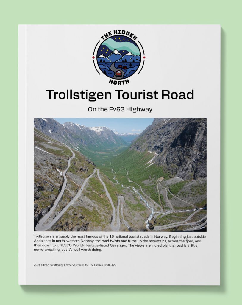
Trollstigen is arguably the most famous of the 18 national tourist roads in Norway. Beginning just outside Åndalsnes in north-western Norway, the road twists and turns up the mountains, across the fjord, and then down to UNESCO World-Heritage-listed Geiranger. The views are incredible, the road is a little nerve-wrecking, but it’s well worth doing.
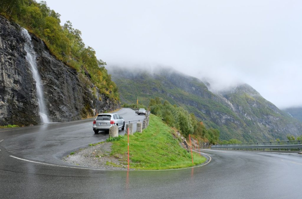
You’ve probably seen something like the image above. Trollstigen has been featured countless times on television programs – especially those about cars – and every guidebook will include a picture of it. The road is slightly terrifying, difficult, and not for the inexperienced. However, get to the top and you will be rewarded!
I got to do the Trollstigen National Tourist Road last September. The weather was miserable and we didn’t see anything, but that didn’t change my opinion of the road. I’m glad I didn’t do it in the middle of summer – the traffic looks like a nightmare. Here’s an overview of everything you can see and do on the road between Åndalsnes and Geiranger.
In this article...
Download this Guide
All of our guides can be downloaded via our online store.
We offer downloadable versions of our self-guided drives on our online store.
Online Guide
- Information about points of interest
- Images of each point of interest
- Historic overview of the neighbourhood
- Directions between points
- Historic photos
- Information about facilities along the way
Downloadable Guide
- Information about points of interest
- Images of each point of interest
- Historic overview of the region & towns
- Directions between points
- Historic photos
- Facilities including supermarkets, toilets, petrol, hotels, cafes, restaurants with addresses.
Watch on Youtube
All of our roadtrips are available on YouTube to watch. They include information about the area provided in text and voiceover form, plus they show the drive in full (sped up in some spots!) so you can get an idea what the drive is like.
IMPORTANT: TROLLSTIGEN CLOSED
Please note that Trollstigen Tourist Road is closed until July 2025 due to concerns over rockslides and subsequent safety issues. It is possible to visit the visitor centre and viewpoint at the top, but you must come from the southern (Valldal) side. It is not possible to drive on the Trollstigen switchback road.
The Drive: Åndalsnes to Geiranger
Åndalsnes
This drive begins in Åndalsnes, which is a popular place to stay for those who love outdoor activities. You can learn more about Åndalsnes via the button below.
Troll Wall (Trollveggen)
Mountain Range
If you continue past the turn for Trollstigen, you’ll be driving along Trollveggen.
Trollveggen is the tallest vertical rock face in Europe, about 1100m (3600ft) from its base to the summit ridge of the highest point. The wall is popular with skiers and mountain climbers.
The drive along the E134 provides excellent views of Trollveggen, though the best views are achieved by hiking.
If you want to see the whole of Trollveggen, drive to Dombås and back again. One way is 104km (90 minutes), so it is a day trip. Otherwise, you might be coming from Oslo and do the drive from Dombås into Åndalsnes anyway.
Rauma River
River
The Rauma river is a 68km (42 mi) long river that runs through Romsdalen, the valley you drive through for Trollveggen. The river used to be famous for salmon fishing, but since an infection, only 5-10% of the stock survives.
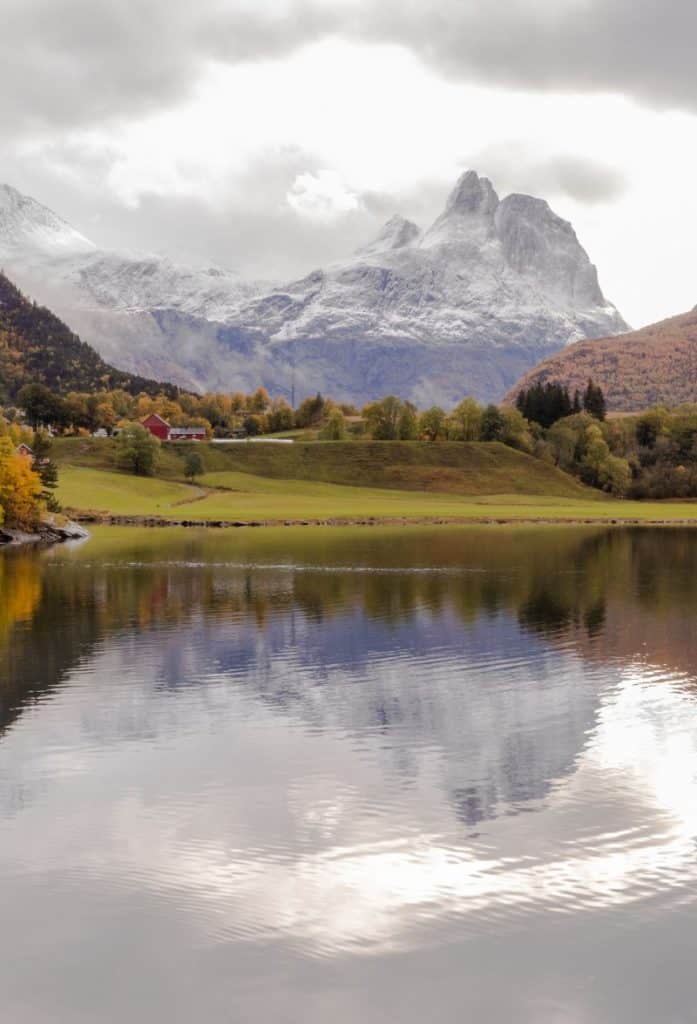
The Rauma River is regarded as one of the most beautiful in Norway. It has a natural green tint from melting ice. The mountains on either side are 1500m – 1800m (4900ft to 5900ft) high.
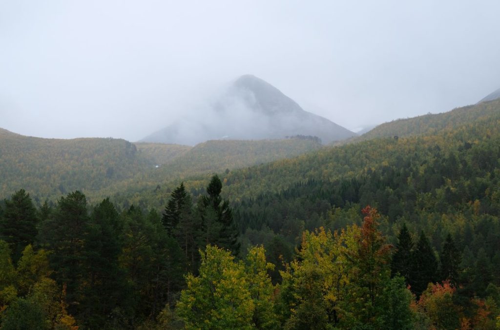
Isterdalen
Valley
We are in the valley called Isterdalen. It is a distinct U-shaped valley with a steep end point: this is where Trollstigen is. The valley is cultivated for agricultural purposes.
When driving through the valley, keep an eye out for the famous mountains “Queen”, “King” and “Bishop” on the west side of the valley.
Trollstigen Resort
Accommodation
This quirky cabin rental and camping ground has some – unique? – troll statues you can stop to take photos of. They also have a shop with food and drinks, plus some restrooms.
Besides the trolls, it’s worth stopping here to look at the maps of the surrounding area.
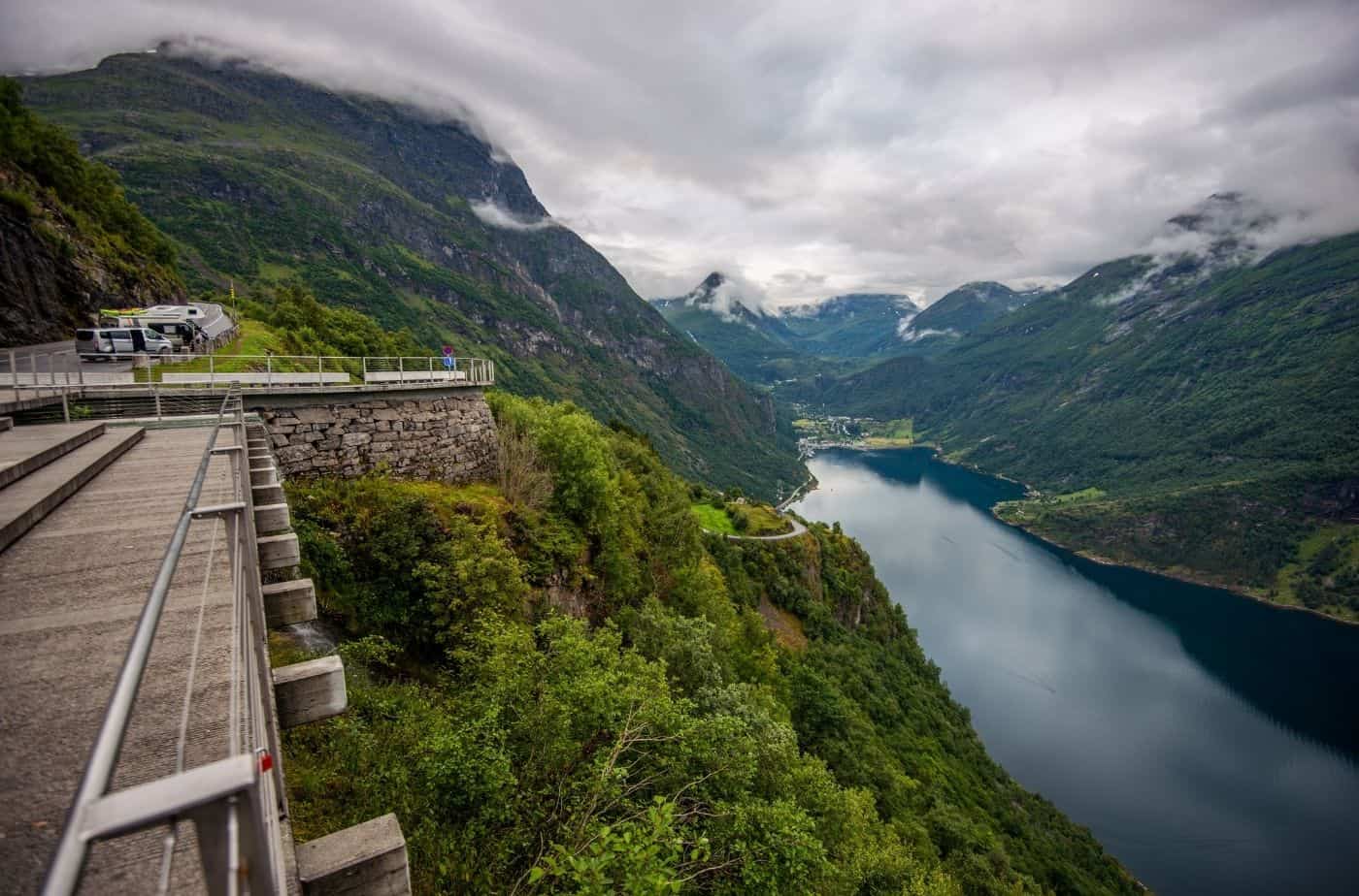
Trollstigen
Historic Overview
The road is very old. The market near Åndalsnes began in 1533, and the road was used as the main crossing over the mountain. A text in 1766 says that the mountain road was inspected annually and continuously.
Around the turn of the 20th century, the road was widened to allow for riding: it was around 1.5m wide. Discussion began for modernising the road and allowing access for wider vehicles. The Armed Forces was interested in the construction of the road for the sake of mobilisation and exercises in connection with a nearby military camp. Additionally, the opening of the Rauma Line provided subsidies for the construction of the road.
In 1912, county engineer Hovednark said that the road would become “one of our most important tourist roads.” I’d say he is right!
In 1916, upgrading of the road began. Throughout the building process, the road was criticised for being an expensive project, but the council began to work on it. The construction of the hairpin turns began in 1930. The turns were designed so they would not be too sharp. Work was done by hand with wheelbarrows, hammers and drills. Two men could do 3m of road a day. Eventually construction workers laid rails on the road so stones and gravel could be transported away.
Trollstigen officially opened on 31 July 1936 by King Håkon VII. It is practically on the same route as the older path; though most of the older path is the Kløvstien walk.
Renovation Work
Due to the location and weather, Trollstigen is continuously monitored. Due to rockfalls, a section at the bottom of Trollstigen was rebuilt in 2005. The road from Trollstigen to Geiranger was upgraded between 2005-2008 due to the large number of tourists crossing.
Some of the turns have been widened to allow for buses to get up/down.
The Turns
Each turn is named after the work team member who was responsible for that turn. From the bottom:
– Otmar Østigård
– Johan Voll (turns 2-4)
– Kjelstad
– Anton Fiva
– Lars Daniel Tafjord
– Martin Uri (8 and 10)
– Arthur Langdal
– Volda (now called Bispesvingen)
The turns are named so if you get stuck you can tell the emergency authorities where exactly you are.
Stats
- 11 hairpin bends. Several have been widened, while others are their original width
- There is a 1:12, or 10% gradient
- The highest point is Alnesreset, where the info centre is, and it’s 850m high
- The road is 4-6m wide – more at meeting places. When the road first opened, it was 3-4m wide
Trollstigen Visitor Centre
Centre
At the top of Trollstigen is this incredible looking visitor centre. The complex is fairly new: it was built in 2012. Perhaps unsurprisingly, it was designed by an architecture firm.
Here you’ll find restrooms, food, drinks, and souvenirs. There are walking paths all around the centre, and two viewpoints where you can capture that famous view of Trollstigen.
Since I went on a horribly day, I didn’t get a photo of the road. It’s okay, I can always go back!
Fjord Municipality
Shortly after leaving the visitor centre, we cross into Fjord Municipality (Kommune).
Fjord is a small municipality in the traditional district of Sunnmøre.
The name ‘Fjord’ is kind of strange. It is not an old or historic name: it was chosen in 2020 for reasons of search enging optimisation. If you google ‘Fjord’, they wanted their muncipality to be the first in the list and bring tourists to the region. They have been criticised by the Language Council of Norway because fjord is a very common place name in the country. Also, they were unhappy that the name was chosen for SEO; they said that names should be based on names with a historic tradition in the area, and that ‘invented names’ with no tradition such as Fjord are unfortunate.
I tried it and the municipality was not at the top of my list on Google!
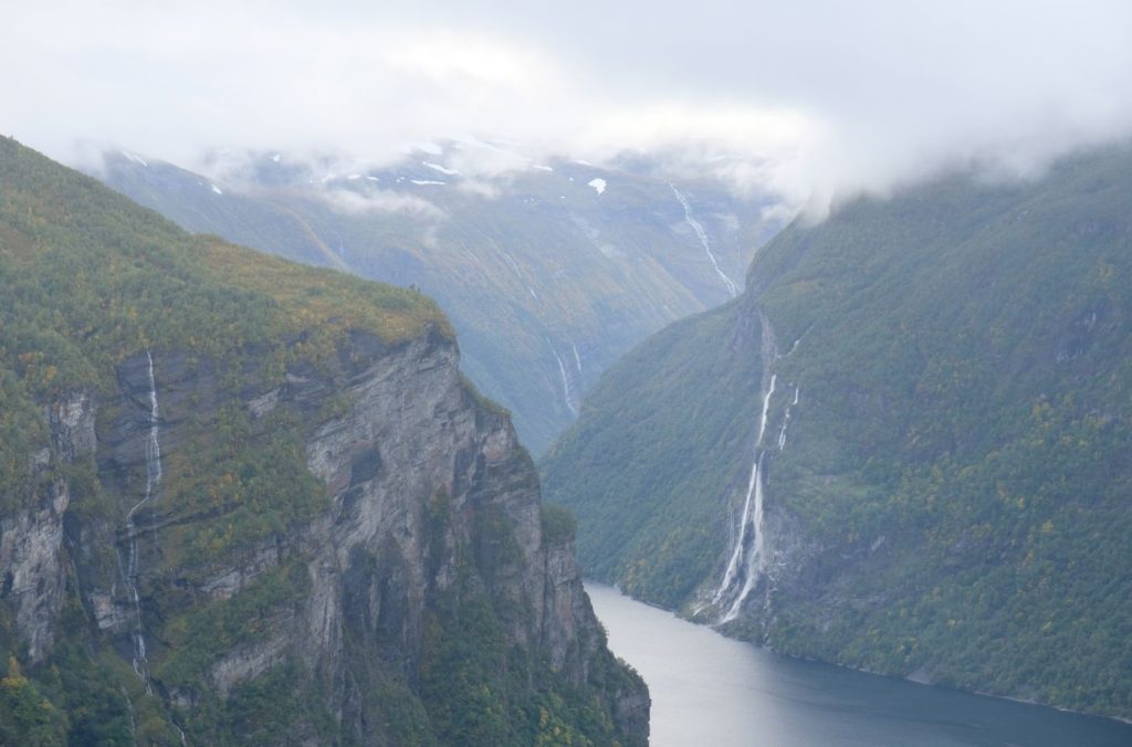
Gudbrandsjuvet
Scenic area
After a short drive, you’ll pass brown tourist signs leading you to Gudbrandsjuvet. This is a short detour with some incredible views.
Gudbrandsjuvet is a 5m narrow and 25m high ravine. There is a stone bridge across the river: it’s from 1919 and replaced an even older bridge from 1785.
According to a story from the 1500s, the ravine was named after a man called Gudbrand. He ran off with his new bride and saved himself from his angry pursuers by jumping over the ravine at its narrowest point. Gudbrand was declared an outlaw for his deeds, and lived the rest of his life in a stone hut in one of the side valleys above Gudbrandsjuvet. The valley is still called Gudbrandsdalen (not to be confused with the Gudbrandsdalen north of Oslo) to this day. The story doesn’t mention whether his bride followed him over the ravine.
There’s a gorgeous visitor centre and platform here. Have a look at the pictures on the VisitÅlesund website (click here).
Fun fact
The British film Ex Machina was partly filmed at the Juvet Landscape Hotel. The hotel is just behind the viewing platform. If you want to stay there, you have to stay for a minimum of 2 nights and pay 4500 NOK per night.
Valldal
Valley
Valldal is a valley and high tourist area. We’ve been passing caravan parks and cabins for the last 15 or so minutes, so that’s definitely their main industry.
The valley runs for 30km from Storfjorden to Trollstigen. The valley is relatively flat with a gentle slope, providing great opportunities for agriculture. The valley rises from sea level (by the fjord) to 850m above sea level at Trollstigen.
St. Olav & Valldal
Even though the valley is assoicated with tourism today, it is very old. Valldal is mentioned in the Old Norse Sagas. In the Saga of St. Olav, it’s written that Olav fought with a sea serpent in the Storfjord (the fjord Valldal sits on). Olav wins the battle by throwing it in the rock wall of Syltefjellet. To this day, you can see an outline of the serpent on the side of the mountain Syltefjellet.
Just above the centre of town is Olavsstøtta. This is a monument commemorating the place where Olav sat and watched his boats burn so the enemy could not use them. After that, he set out across Valldalen – the valley we’ve been driving through. As Olav made his way through the valley, he got help from the locals who lived here. As a way to say thanks, he promised that the grain here would never freeze. According to the locals, it has never frozen!
There’s another place named after him – Olavskilda – which is a spring with water said to have a healing effect. Before the modern times, it was used to give to animals that were unhealthy.
Tourism
Valldal is located in the centre of two important tourist destinations in Norway: the Geirangerfjord and Trollstigen. Vallden is located on the tourist route between the two, and understandably it gets a lot of traffic.
Valldal is surrounded by mountains that are 1500-1800m above sea level. As you can imagine, the surrounding nature attracts a lot of tourism. There are plenty of marked hiking trails in the area, and the Norwegian Tourist Association’s cabins can be found in the region.
Valldøla, which flows through the river, is known for its salmon and trout fishing. Fishing licences can be bought at the tourist centre in Sylte. Hunting is also common here. Valldal has a large deer herd that every autumn provides food for landowners. Grouse hunting is also possible at the top of the valley.
Agriculture
This is the most important industry in Valldal. The valley is known for strawberries. Before the municipality was changed to ‘Fjord’ it was called Norddal and the coat-of-arms was three berries. Besides strawberries, there are also apples, pears, plums, apricots, cherries and walnuts growing in the valley.
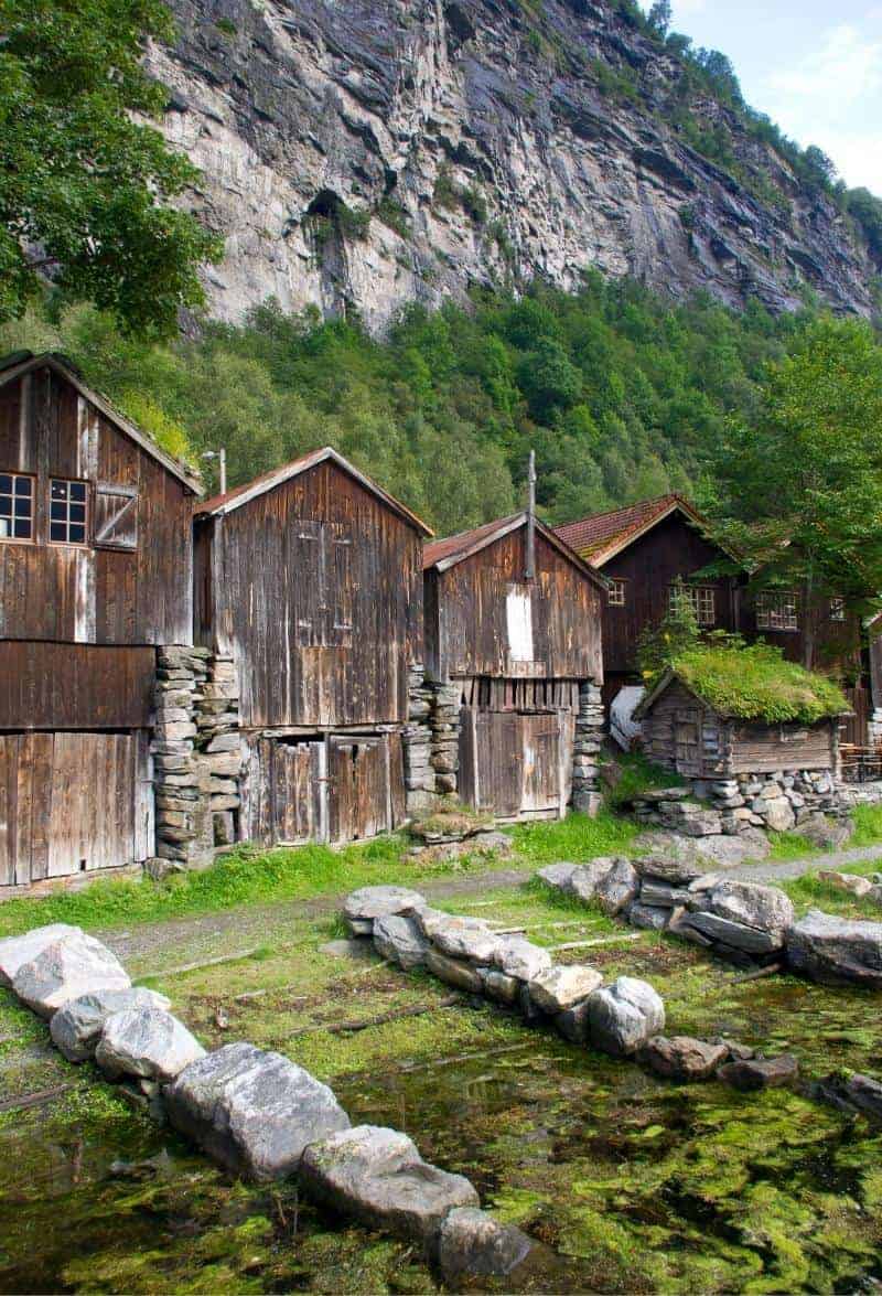
Sylte
Sylte is the name of the settlement by the fjord, but it’s often also called Valldal town centre. Around 1000 people live here. Historically, Sylte was a common area used by the farmers of Valldal where they all had a boathouse and stalls where they could store horses while attending church as well as private belongings. The area has now been developed and has a petrol station, car repair shop, and grocery store.
Sylte Church is from 1863. It’s believed there has been a church here for a long time. The site is mentioend in documents as far back as 1589. Some guesses believe that the first church was built in 1100 after church building became common.
Linge to Eidsdal
Ferry
When we get to Linge, we take the ferry over to Eidsdal.
It’s worth noting that the ferry pier in Linge is one of the attractions along the national tourist route. I don’t know if you’ll spend any time there: we just went straight to the ferry. Click here for info about the attraction.
To take the ferry, join the queue in the parking lot. The ferry comes every 30-45 minutes, so you don’t have to wait long. When you are signalled, drive onto the ferry and make sure you park as close as possible to the car in front of you. You then have to turn off your car and leave it.
How to buy a ticket? Easy. They scan the e-toll tag inside your car. All rentals will have one. After you drop off the car, the rental company sends you a bill for all the tolls/ferries you took.
When you see the ferry getting closer to the other side, go back to your car. Don’t turn it on until you’re docked. Leave the ferry when instructed. Easy!
Most ferries serve hot and cold food and drinks and have restrooms.
Eidsdal
Village
Eidsdal is a tiny town. Around 400 people live here, and the major industry is agriculture. Tourism is fastly becoming a major industry, with many campsites, cabins, and guesthouses being built in recent years.
If you find accommodation in Geiranger is sold out – which is common – or it’s too expensive, Eidsdal is a great affordable alternative. It’s a short drive from Geiranger but accommodation can be half the price for the same standards.
Herdalssetra
Farm
Herdalssetra is a preserved mountain summer farm and one of the largest alpine farm centres for goat farming. The farm has been in continuous operaton for 300 years. It has several hundred goats, plus some cows, sheep and fjord horses. There are over 30 historic buildings gathered in a cluster. During the summer, the farm is open to the public. You can visit these historic buildings and watch as brown and white goat cheese is produced using the traditional method. The farm also has courses you can take and a café where you can try what’s made here.
If you see the Snøfrisk brand in supermarkets – that is what is produced here!
The drive up the toll road is 10km and steep and narrow, so be careful! Honestly, this place is spectacular and I really recommend it.
The farm is free to access and is open in the summer when the snow has melted. Check their website for info. The drive is about 30 minutes from Eidsdal.
To get there, you can use GPS (it’s ‘Herdalssetra’ on Google Maps) or drive along the fjord to Norddal and then take the only road that goes up the valley.
Stranda Municipality
The next municipality we drive through is Stranda. It’s a typical fjord municipality with one large town and three small villages: most of the municipality itself is either fjord or mountain.
Due to the natural environment, Stranda Municipality is one of the most visited in the Nordic countries. Tourism has long traditions here, with the first cruise ship coming into Geiranger in 1869. Today, Geiranger is the second-largest cruise ship port in Norway after Bergen.
Besides tourism, agriculture is an important industry with around 160 farms producing milk and meat products. Many factories have long traditions for producing meat products, especially salted and cured meat. One of the most famous companies here is Orkla, which produces frozen pizzas (among other things). Since 1979, over 500 million frozen pizzas have been produced at the factory.
Norwegians are obsessed with frozen pizzas. The number one hit song in 2005 was all about the love of frozen pizza. Click here to hear it.
Ørnesvingen
Scenic Road
Ørnesvingen is a series of 11 hairpin bends that will take you down to sea level from 620m high. At the top of the bends is the Ørnesvingen viewpoint platform, where you get a spectacular view of the Geirangerfjord, the Seven Sisters, and Geiranger village.
The road officially opened on 15 September 1955, giving Geiranger a year-round road connection. Yes, this is the only road open in and out of Geiranger all year round. The road got the name “Ørnesvingen” because the area traditionally had lots of eagles (Ørnes = Eagle).
The climb is steep – 10% – and it can be difficult in summer but especially winter. Traffic can make it difficult as well, so just take your time.
The viewing point is worth stopping at but it creates its own set of issues. The parking lot is small and during summer it’ll be crowded with buses. Then, you have to cross the road to get to the viewpoint. There are no lights or pedestrian crossings; you just have to make a run for it. If you are spending the night in Geiranger, I recommend coming back later in the day if it’s too crowded. The area also creates traffic jams.
Geiranger
You have now made it to Geiranger!
You can learn about Geiranger through our travel guide.
Continue the drive
Geiranger - Lom Drive
Drive up the mountains on this continuation of the tourist road.
Previous Route
If you liked this drive, or if you have any travel tips, please leave a comment in the section below!