
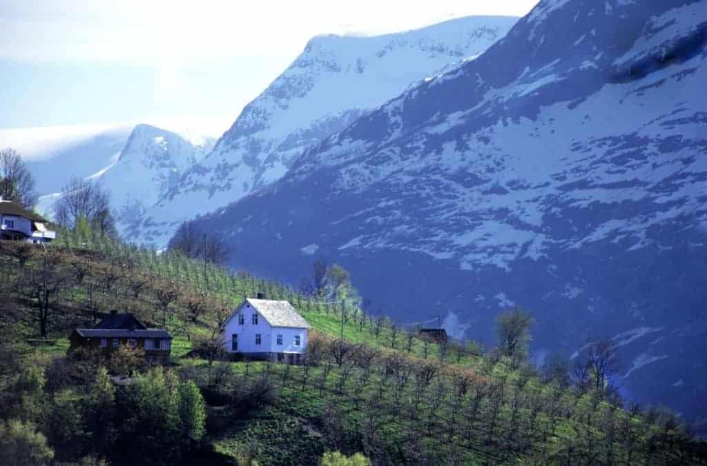
I think one of the best ways to see Norway is by car. It may seem a little intimidating at first, with all those mountain roads, ferries, tolls, and crazy expensive petrol. But if you plan accordingly and have the budget for it, you’ll get to see the best bits of nature. And one of the best things to do is driving from Bergen to the Hardangerfjord.
There are two ways to get to the Hardangerfjord from Bergen: the Hardanger Scenic Route and the main highway to Granvin through Voss. The Hardanger Scenic Route certainly sounds appealing, but if narrow fjord-side roads make you nervous, or you’re short on time, the main highway is an excellent alternative.
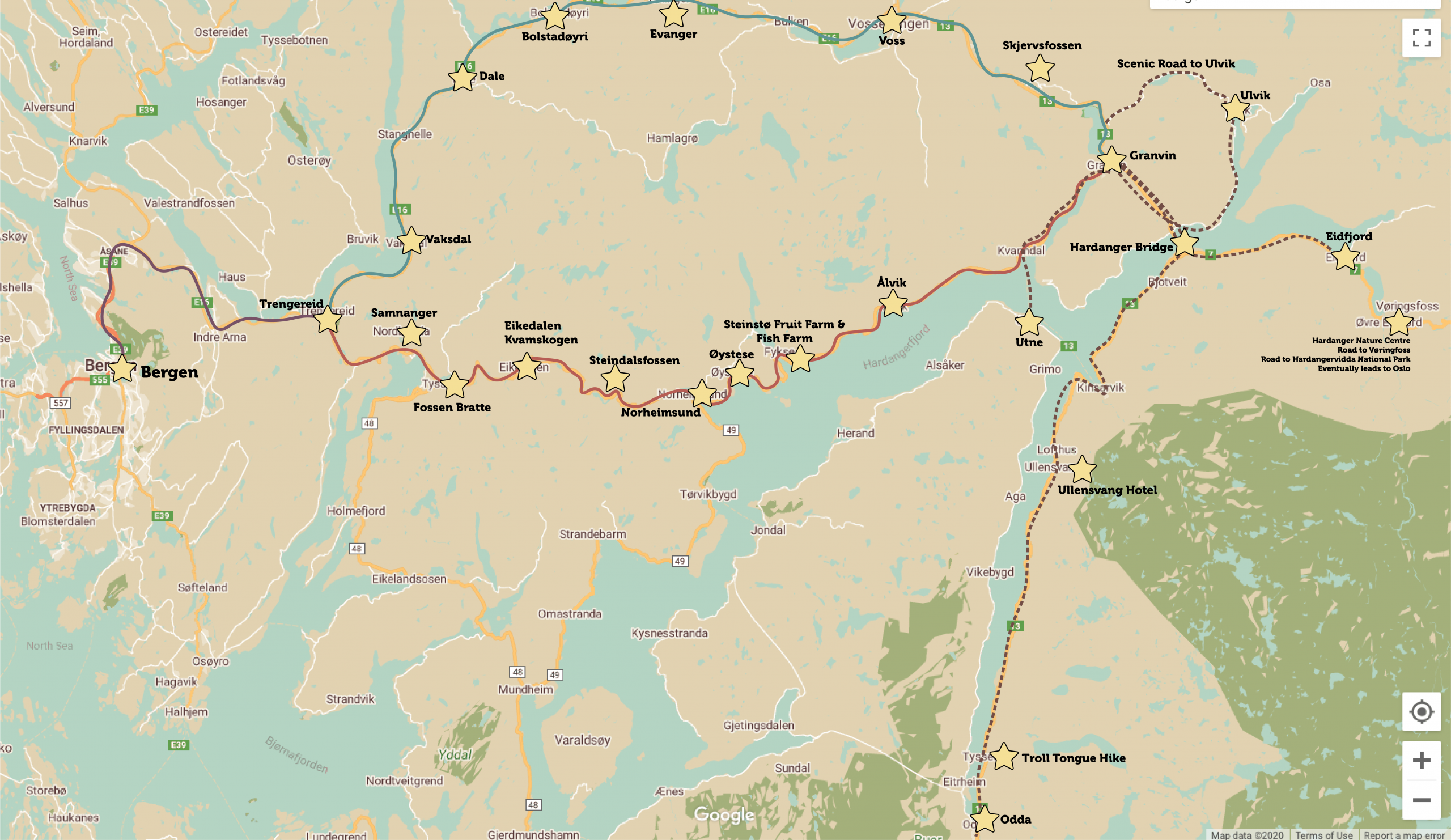
I’ve done both ways so many times; my family is from the innermost part of the Hardangerfjord so we always try to make a day of it when we are going to the farm. Also, it’s common to do day tours to Hardanger from Bergen.
For my overview, I’ve used Granvin as the end-point. It’s not really famous for anything; it’s a crossroads. From Granvin you can head to Ulvik, Eidfjord, Utne and Odda: four very popular places to spend the night. The advantages of each of them:

Where to Stay in Hardanger
Ulvik:
- The famous Brakanes Hotel is a good option for the night
- Ulvik has the apple cider route, where you can visit farms and try their produce
Eidfjord:
- Leads up to the famous Vøringsfossen and then the scenic road over the Hardangervidda National Park down to Oslo
- Hardanger Nature Centre is located here
- Beware – major cruise port!
Utne:
- Incredibly scenic with a historic hotel
- The Hardanger Scenic Route continues on this side of the fjord
Odda:
- The Ullensvang Hotel is a historic hotel
- The popular hike to Troll Tongue starts at Tyssedal
- Folgefonna National Park
If you are doing this as a day-trip from Bergen and back, it’s very easy to do both roads in one day.
Anyway, here’s my overview of what you see when driving from Bergen to the Hardangerfjord.
The Hardanger Scenic Route
The Practical Info
Distance from Bergen to Granvin: 127km / 79.1 miles
Time from Bergen to Granvin: 2 hours 9 minutes (not including stops)
Toll Cost: 100 NOK [mfn]https://www.fjellinjen.no/private/toll-calculator/[/mfn]
Open All Year? Yes.
Hardanger Scenic Route – Official Website (English)
The turn-off to the Hardanger Scenic Route is located at a roundabout in Trengereid. Here’s what you can see, stop at, and experience as you head towards Granvin:
Ådland Church
Ådland Church is a historic church located just outside Samnanger community. A church as stood on this site since the 12th century and the first church was likely a stave church. A new church was built here in 1652 and then it was replaced in 1851 by the church you see today.
The church is used for weddings, baptisms, confirmations and service takes place every other Sunday.
Samnanger
Samnanger is a small village around 20km (12 miles) from Bergen, though the drive is considerably longer thanks to the mountains. It is separated from Bergen thanks to Gullfjellet, the tallest mountain in the municipality. The village grew in the early 20th century thanks to the construction of hydroelectric power plants in the area.
The body of water you’ll see here is the Samnangerfjord, which is 22km (14 miles) long and forms the southern boundary of the Bergen peninsula.
Facilities:
Grocery stores (SPAR and Kiwi Bjørkheim)
Cafe/Kro (MIX)
Petrol Station
Mørkhølsfossen
Mørkhølsfossen is a waterfall located alongside the road. There’s a place to park the car and go for a short 400m walk along the river.
Facilities:
Rest stop

Fossen Bratte
Fossen Bratte is a more well-known waterfall along the Hardanger Scenic Road. The waterfall is 80m long.
During World War II, the valley was the scene of fighting when the Germans were making their way inland. There was a barrier position put up in the bend in the road where the waterfall throws itself out. If you walk to the top of the waterfall (there is a path), you’ll see a cannon and some signage commemorating the Norwegians who lost their lives here from this fighting.
If you walk to the bottom of the waterfall, which again is on a path, you’ll come to another memorial. In 1951, a married couple were on their honeymoon when they drove off the road here. The waterfall is nicknamed the ‘bridal veil’ and many think it’s from that, but the nickname has been used since the early 20th century.
This is a very popular stop and the carpark is tiny.
Facilities:
Restrooms
Car parking
Eikedalen
Once you’re on the other side of the tunnel after Fossen Bratte, you’ll see many, many cabins on the hillside. This is the area known as Eikedalen and Kvamskogen, and it’s a popular ski area for the Bergen locals.
Eikedalen is the name of the ski centre that is soon on your left. It has the 10th longest chairlift in Northern Europe at a length of 1800m. The highest peak is Grøtet, which is 918m above sea level. In total, Eikedalen has a total of seven ski lifts with 12 slopes.
Kvamskogen
Kvamskogen is the name of the mountain plateau and region. In total, there are over 1700 cabins in this area; the third-highest concentration of cabins in the country.
Historically, this was a mountain pasture of the farmers from Steinsdalen (where Steindalsfossen is). The farmers used the area to cut grass that would then be brought home by horses in the winter. Much of the wood the farmers needed was also here.
The road you’re on was the main road between Bergen and Eastern Norway in 1907. From the post-war period onwards, the drive was increasingly difficult due to the number of parked cars on Kvamskogen. Even though the road has been widened and carparks added, it can still sometimes take a long time to pass through here.
The Old Highways
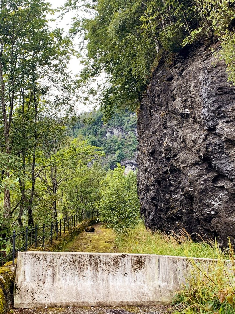
Once past Kvamskogen, the road has four tunnels as you make your way down to Steinsdalen (Stein Valley or ‘Rock Valley’). These four tunnels were built in the 1950s after the old highway was becoming increasingly dangerous.
As you drive through the tunnels, there are openings on the side that shows the old road. The old road was built between 1903 and 1907, with large sections built by hand while workers hung from ropes. The rock in the mountain is ‘junk rock’ and is slowly breaking apart, meaning, there were lots of rockslides on the road. This is why the tunnels were built.
After the last tunnel, there is a parking area to the right. However, when I stopped there recently the rock was crumbling under the carpark and the fence was almost hanging off the side. Not the safest spot to stop.
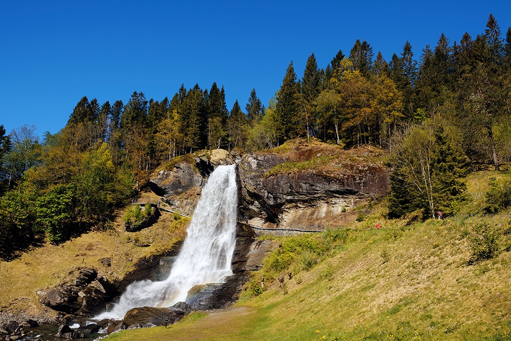
Steinsdalsfossen
This is one of the most famous waterfalls in Norway. You are able to walk behind the waterfall without (mostly) getting wet. It is at its most full in May-June when the snow is melting. The drop of the waterfall is 20m.
Facilities:
Toilets (closed October – May)
Souvenir shops (two of them!)
Coffee and snacks
Information boards
Norheimsund
Norheimsund is a small town with a settlement of 4,399 inhabitants. It is the shopping hub for the outer Hardanger region and has plenty of shops and facilities. Norheimsund is also a traffic hub. From here, you can take a ferry to Utne and Odda, or take a bus to Bergen, Voss, Vikøy, Tørvikbygd, Jondal, Strandebarm and Kvinnherad.
The town centre of Norheimsund was destroyed by a fire in 1932 and has been rebuilt in a functionalist architecture, so it’s not the most beautiful place. During World War II, the occupying forces had a large training camp in Norheimsund and defence installations were built against the fjord.
The Hardanger Maritime Centre is a foundation that restores and protects different types of boats. It’s possible to visit the area during the summer season.
Facilities
Hotels (Thon Hoten Sandven)
Shopping Mall (Straumen Senter)
Grocery stores
Sporting goods store
Pubs, restaurants, cafes
ATM
Hardanger Maritime Museum & Maritime Centre
Emergency room
Petrol station
Øystese
Øystese is a small town just 7km (4 miles) from Norheimsund. The town is on the up and up, with a brand-new Hardangerfjord Hotel and Spa built alongside the fjord.
There’s a quirky sculpture museum here with the works of Ingebrigt Vik. The building looks like it shouldn’t be in a small Norwegian village.
Øystese itself is known for its furniture production, especially in tables. There’s also a printing press here, dairy factories and shops. The church was built in 1868 and is a typical 19th century church.
Facilities
Hotels (Hardangerfjord Hotel)
Grocery stores
Electronics shop
Cafes/restaurants
Pharmacy
Petrol station
Art House Kabuso
Hardanger SkySpace
Fyksesund Bridge
Shortly after leaving Øystese you’ll cross the Fyksesund Bridge. It is 344m long with a span of 230m. It was opened by Crown Prince Olav on 9 Octobe 1937 and at the time it was Northern Europe’s longest suspension bridge.
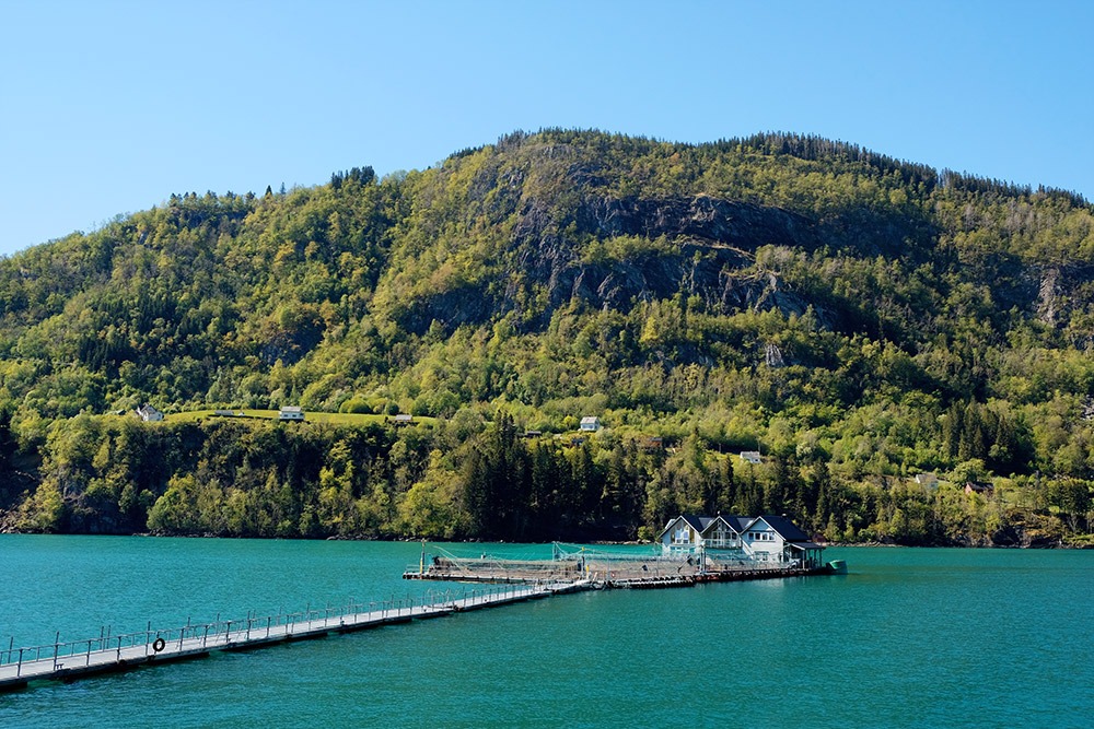
Hardanger Akvasenter
Immediately after the bridge is the Hardanger Akvasenter, an active fish farm that you are able to visit. The main display centre/museum is in Øystese, but if you book ahead you can have a tour of the fish farm. At the fish farm you’ll learn about how salmon farming works. The fish farm is owned by Lingalaks AS, which is responsible for the fish production in the area. It’s a family owned company that today has about 2.5 million fish in their farms and employs 40 people. If you stay at the Hardangerfjord Hotel, you can taste the salmon there.
Steinstø Farm
Steinstø Fruitfarm has been owned by the same family for nine generations. If you visit the farm, you can learn about how the farm is run and how it was run in the past. There’s a shop by the road that sells fruits and berries as well as homemade apple juice, homemade jam, jellies, lefse, apple cake and souvenirs. There’s also a small café where you can have coffee and cake. Restrooms are under the building.
In any case, it is possible to book a visit to the farm, but it’s often reserved for groups.
Steinstø has become very popular in recent years, so if you’re visiting in summer you may see a couple tour buses parked out the front.
Facilities
Cafe
Restrooms
Shop
Note: Their opening hours vary quite a lot throughout the year. Check the website/Facebook page before going:
https://www.steinsto.no/english
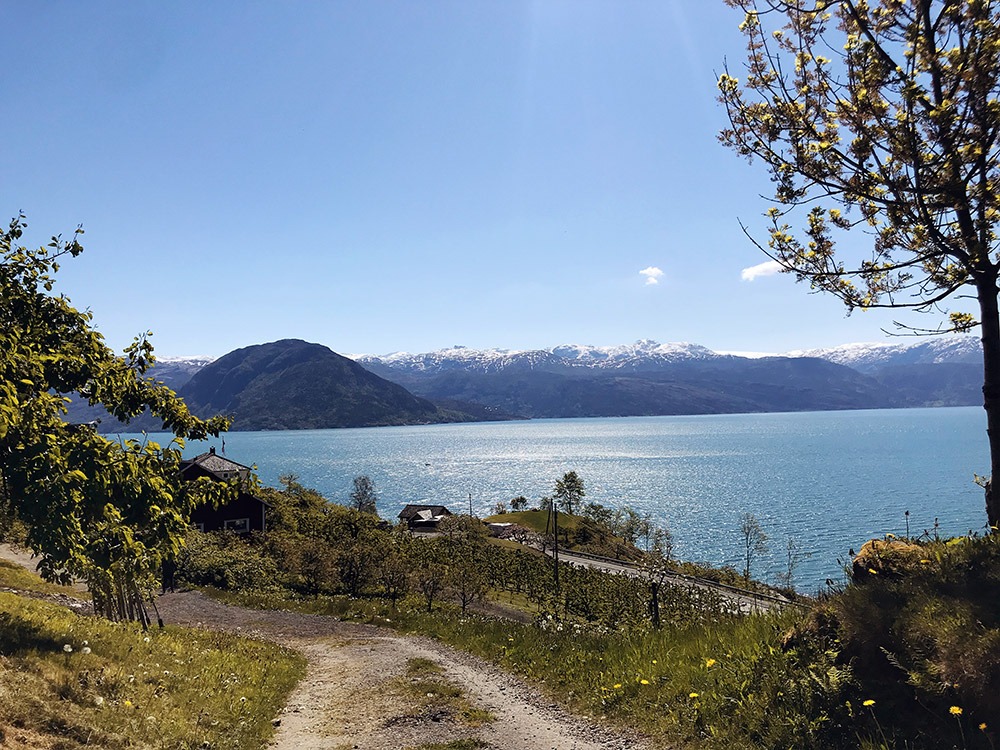
Steinstøberget Rest Place
The rest area is an idyllic spot with a view over the Hardangerfjord. On a clear day, you can see the Folgefonna glacier. The area is built on two levels.
Facilities
Toilets
Picnic/BBQ
Information board
Ålvik
Ålvik is a small town that is known throughout Norway for its industrial site. A factory was built here at the beginning of the 20th century to take advantage of the hydroelectric power from the Bjølvo waterfalls. The factory was completed in 1919, producing calcium carbide for a time. The villages population rose from 75 to 500 following the opening of the factory. In the 1920s, the company was given major sales contracts for ferrosilicon to the British steel industry. A production line for ferrochrome was established in 1934.
The road connection to Bergen was added in 1937.
The plant made Ålvik the most polluted place on the Hardangerfjord and at times the whole town could be covered in smog. Government environmental regulations put pressure on the company, and ferrochrome production ended in 1979. Ferrosilicon was prioritised to comply with environmental standards and furnaces were rebuilt, making it possible to recycle excess heat.
The factory is still the village’s main employer. It is now a subsidary of Elkem, which is owned by China National Bluestar. Today the factory recycles waste from aluminium production. The hydropower plant is now owned by Statkraft.
The Ålvik Industrial Worker’s Museum documents the village’s labour heritage through the exposition of two restored workers apartments typical to the 1920s and 1950.
Today Ålvik has a primary school, kindergarten, nursing home, church, library, several artists and plenty of hiking trails.
Granvin
You’ll drive alongside the Granvinfjord before you make it to Granvin, and this part of the drive is especially narrow! The Granvinfjord is 10km (6.2 miles) long and less than 1km wide. At the end of the fjord you can see the lumber and wood products industry, which in 2019 accounted for 80% of all industry-related employment in the area. Granvin is home to one of Norway’s few spruce forests.
The name Granvin comes from an old farm that used to stand here. The coat-of-arms is the Hardanger Fiddle, which is representative of the folk tradition of the region.
During World War II, there was some fighting between German and Norwegian forces here. Germans landed in Granvin on the 25th of April as part of their movement towards the military camps at Voss. Four Norwegians and at least 30 Germans fell during the fighting. The population has decreased significantly since the war. 29% of the population here commute to Voss for work.
Granvin is an agricultural area characterised by livestock, mainly sheep. There’s a fantastic shop you should visit – Kjerland Gardsbutikk – where you can look at and buy produce from all the surrounding farms.
Facilities:
Rental homes
Grocery stores
Charging station for electric cars
Kjerland Gardsbutikk
The Highway Through Voss
Here’s option two! Driving from Bergen to the Hardangerfjord through Voss is a great option ff you’re short on time or don’t want to drive on narrow roads.
The Practical Info
Distance from Bergen to Granvin: 129km / 80.4 miles
Time from Bergen to Granvin: 1 hour 52 minutes (not including stops)
Toll Cost: 72 NOK [mfn]https://www.fjellinjen.no/private/toll-calculator/[/mfn]
Open All Year? Yes.

Vaksdal
This will be the first point of interest after going through Trengereid. Vaksdal is a small community known for the Vaksdal Mill, which was established in the late 19th century using power from the nearby waterfalls. The waterfall was first utilised with mechanical transmission of power to the mill machines. Vaksdal Mill was once the largest mill plant in Northern Europe. During World War II, there was heavy fighting in Vaksdal between the 19th and 23rd of April. Three Norwegian soldiers and one civilian and a larger, but unknown, number of German soldiers fell in Vaksdal.
Dale
If you love knitwear, you’ll love Dale! This small village is famous for Dale of Norway, a Norwegian knitwear brand. The business was established in 1872, when industrialist Peter Jebsen (1824 – 1892, you can see his house on my Årstad walk) first established a textile factory in Dale. After World War II, the factory developed exports of its knitted sweaters. Since 1956, Dale of Norway has designed and produced official Olympic and World Championship sweaters for the Norwegian National Alpine Ski Team. They were also later chosen to design the official sweaters for the Winter Olympic Games through the IOC, with rights to use the Olympic symbols.
It’s possible to visit the Dale of Norway factory. If you plan ahead you can take a guided tour. If you just show up, there’s a great outlet store!
Dale has a small church, the Dale Church, which dates to 1956 and can be seen from the road.
Facilities
Roadside Cafe
Petrol station (shell)
Dale of Norway Factory Outlet and Museum
Grocery Stores (Coop Extra, SPAR)
Bolstadøyri
Bolstadøyri is a historic spot on the old route between Voss and Bergen. Before the train link was built, transfer between the two was by horse and boat. This is where the boat journey started.
Evanger
Evanger is a traditional West Norwegian village. The village was destroyed by a fire on the 10th of April 1923 and was rebuilt exactly how we see it today. Because of this, Evanger town centre has been regulated as a special area of protection as a culturally and historically valuable building environment. Evanger Church escaped the fire and was built in 1851.
After that, outside the courthouse is a monument to Knute Nelson, who was born here and emigrated to the United States in 1849. He became a lawyer and politician and was for many years a senator for Minnesota.
Evanger is famous in Norway for its cured meats. There are several companies here that specialise in the production of traditional food.
Facilities
BnB
Grocery store (Landhandleri)
The Voss River
The Voss River is a famous salmon river. When tourism was growing in the 19th century, English ‘salmon lords’ would travel here to catch some top-notch Norwegian salmon. The biggest salmon to be caught here was 32kg! In the last few decades, the salmon population has declined due to pollution, disease and other unknown factors.

Voss
Welcome to Voss! There’s a lot to do in Voss, and you could easily spend a night here.
According to legend, the people of Voss were forcibly converted to Christianity by King Olav, who later became Saint Olav. There’s a stone cross located by the lake that is said to have been erected at this time.
The Voss Church is built on the site of an old pagan temple. The church was built in 1277 under the instruction of King Magnus the Lawmender and it is one of the few buildings that survived the bombing of World War II.
When Germany invaded Norway on the 9th of April 1940, Voss was the main point of mobilisation for the Norwegian Army in the West since Bergen had fallen. To break down the resistance, the Luftwaffe bombed Voss on the 23rd and 24th of April and then the surrounding countryside on the 25th of April. Nine people lost their lives and the bombings completely destroyed the wood-built town centre. You’ll notice Voss has a very concrete look today; it was rebuilt cheaply during and after the war.
Voss is known far and wide for its extreme sports. You can do skiing, water sports, skydiving, paragliding and other adventure sports here. The brand-new Voss gondola opened in 2020 and it’s used for tourists or for hikers and skiers.
Facilities
All the facilities of a mid-size town (groceries, shopping, ATM, petrol station, cafes and restaurants, etc)
Toilets available at the train station
Voss Gondola
Hotels (Fleischer’s Hotel, Park Hotel, the brand-new Scandic Hotel)
Voss Folk Museum
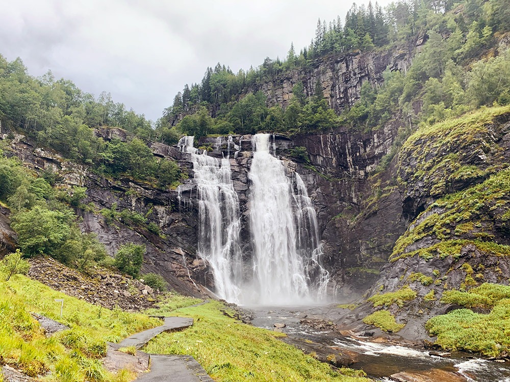
Skjervsfossen
Around half-way between Granvin and Voss is Skjervsfossen. Take the detour road off the main highway for this incredible sight. It’s possible to park at the top and the bottom of the waterfall and well-worth it. There’s a network of paths and stairs so you can walk around the waterfall and surrounding area.
The historic route is called ‘Skjervet’ and forms the old highway.
Facilities
Toilets (closed October-May)
Picnic/BBQ
Information board about the area
Granvin Church
Shortly before arriving in Granvin you’ll pass the Granvin Church, which was built in 1726 and represents a typical example of an 18th century church building. In 2012 the church was listed for preservation as a culturally and historically important example of the richness of decoration in early 18th century churches.
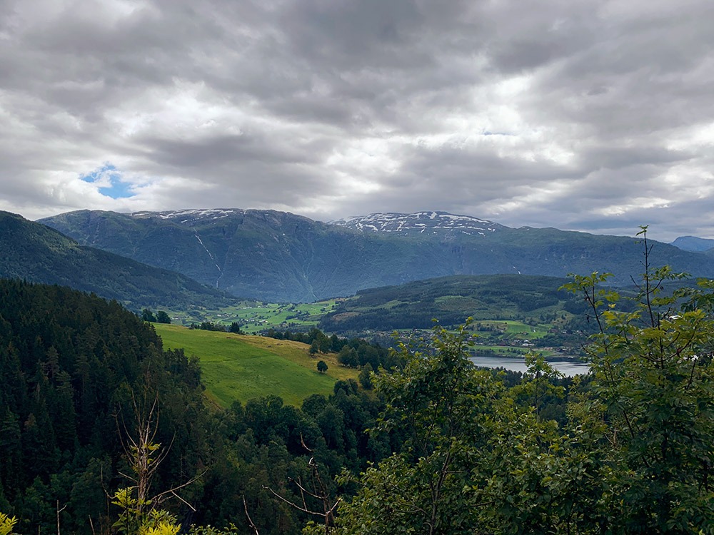
Scenic Detour to Ulvik
If you’re planning to go to Ulvik, there’s a scenic road you can take over the mountain (rather than going along the fjord). It begins in Granvin (there’s a sign for the turn-off) and you can stop at a viewpoint overlooking Ulvik on the way back down. The road also passed the apple cider route in Ulvik.
Driving from Bergen to the Hardangerfjord
In conclusion, I hope this article has given you some ideas about how to drive from Bergen to the Hardangerfjord. In any case, there are no losers. Both drives are incredibly scenic and have unique attractions.
If you have any comments or suggestions please mention them below!